
100 MPH Wind Threat Looms for Boulder and Highway 93 as Mountain Wave Setup Signals Extreme Fire Danger Thursday
BOULDER, COLORADO — High-resolution weather modeling is now painting a more alarming picture for Colorado’s Front Range, with potential wind gusts approaching or even exceeding 100 miles per hour in the foothills on Thursday.
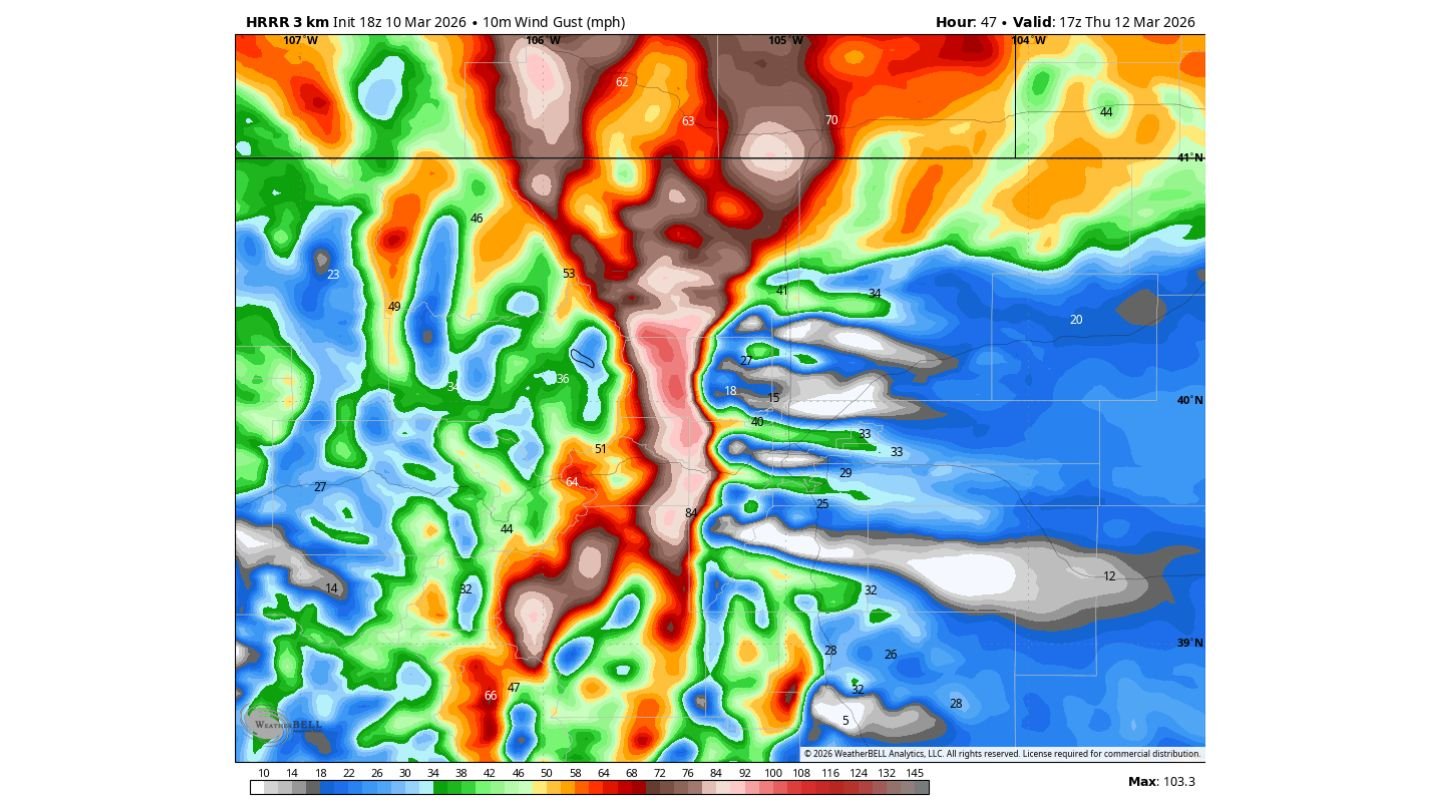
The latest HRRR 3 km wind gust guidance valid Thursday afternoon shows a concentrated corridor of extreme winds along the eastern slopes of the Rockies, particularly near Boulder and along Highway 93 — a classic hotspot during strong mountain wave events.
A Classic Mountain Wave Setup Unfolding
The model imagery highlights a narrow but intense band of peak gusts running north-to-south along the foothill corridor west of:
- Fort Collins
- Boulder
- Western Denver metro
Wind gust values in the most intense zone exceed 90 mph, with localized pockets near or just above 100 mph possible in the strongest mountain wave bands.
This type of setup develops when strong westerly winds aloft descend rapidly down the eastern slopes of the Rockies. As air accelerates downhill, it compresses and warms, dramatically increasing wind speeds in narrow corridors.
Highway 93 between Boulder and Golden is especially vulnerable in these patterns due to terrain alignment.
Where the Strongest Winds Could Hit
The most dangerous gust potential appears focused in:
- Foothills immediately west of Boulder
- Areas near Highway 93
- Elevated terrain west of Denver
- Northern Front Range near Fort Collins
Meanwhile, areas farther east — including Greeley, Fort Morgan, and Sterling — show significantly lower gust potential in the model guidance, suggesting the most extreme winds may remain tightly confined to foothill zones.
However, slight shifts in the wind field could expand impacts into lower elevations.
Higher-End Fire Danger Emerging
Beyond structural and travel impacts, Thursday is shaping up as a higher-end fire weather day.
If 80–100+ mph winds combine with dry air and receptive fuels, any fire start could spread rapidly and unpredictably.
Even if the strongest gusts remain just west of Boulder proper, western suburbs and open space areas could face elevated wildfire risk if downslope winds mix into the urban interface.
Timing of Peak Impacts
Current modeling suggests:
- Winds begin ramping up Thursday morning
- Peak gusts likely during the afternoon hours
- Gradual easing later Thursday night
Drivers along east-west corridors, especially Highway 93 and Interstate 70 near the foothills, should prepare for dangerous crosswinds.
Why This Setup Is Concerning
Mountain wave events are notoriously difficult to fine-tune until the final hours before onset. Small changes in atmospheric stability can determine whether 60 mph winds stay confined to ridgelines — or whether 100 mph gusts crash into populated areas.
Right now, the high-resolution modeling leans toward a strong to potentially extreme foothill event, with Boulder and the immediate Highway 93 corridor in the bullseye.
Residents should secure outdoor objects, prepare for potential power outages, and avoid any activities that could spark a fire.
As this high-impact wind event approaches, confidence in the general setup is increasing — but the exact downhill extent of the strongest winds will be ironed out closer to Thursday morning.
Stay with WaldronNews.com for continued updates as Colorado braces for what could be one of the stronger wind events of the early spring season.