
12z European and AIFS Models Keep Sunday Snowstorm Alive for Washington D.C., Baltimore and Central Maryland as Forecast Hangs on a Razor’s Edge
UNITED STATES — Just when it appeared the upcoming Sunday snow threat might fade, the 12z runs of both the European (ECMWF) and its AI-driven AIFS model are once again signaling accumulating snowfall across parts of the Mid-Atlantic — including Washington D.C., Baltimore, and central Maryland.
Forecasters caution that this remains a highly sensitive setup, with small track shifts capable of dramatically changing outcomes. But the latest guidance refuses to abandon the possibility of a measurable event.
What the 12z Euro Is Showing
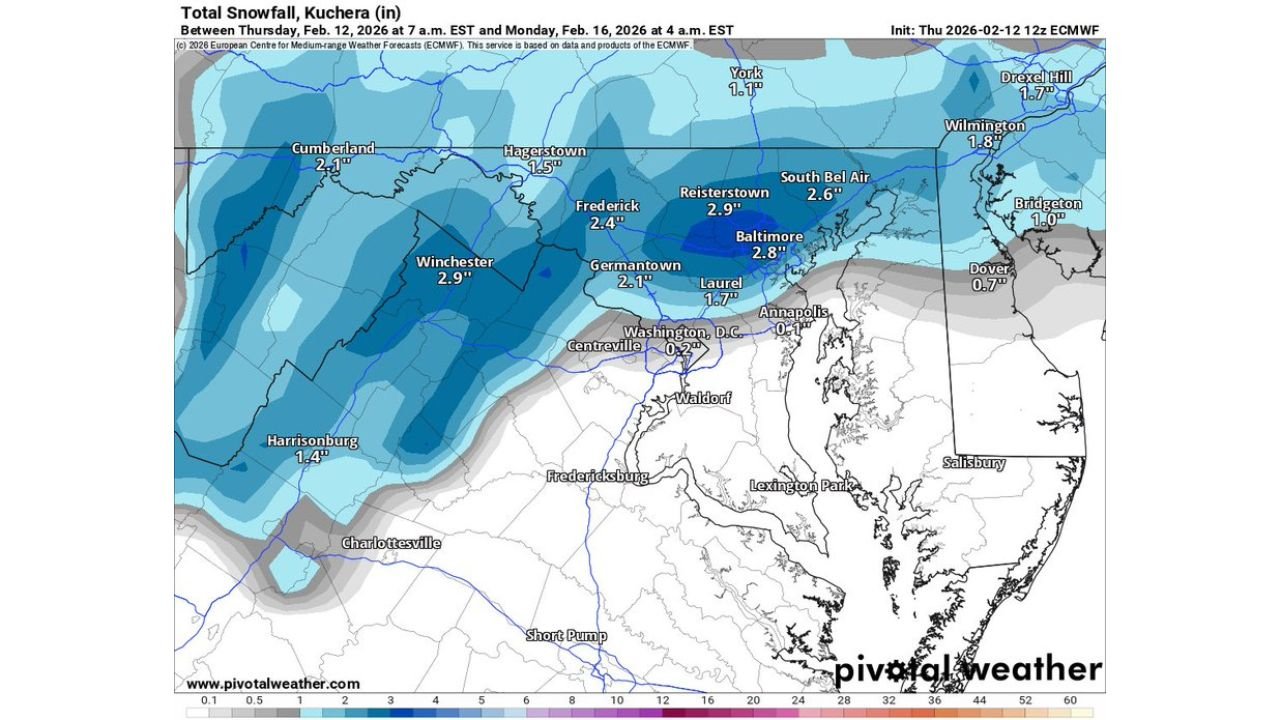
The latest ECMWF snowfall projection (Kuchera ratio) valid late Sunday into early Monday paints a focused band of accumulating snow across:
- Winchester, VA: Around 2.9 inches
- Frederick, MD: Near 2.4 inches
- Reisterstown, MD: Around 2.9 inches
- Baltimore, MD: Roughly 2.8 inches
- South Bel Air, MD: Around 2.6 inches
- Germantown, MD: Around 2.1 inches
Meanwhile:
- Washington, D.C.: Only light accumulation indicated
- Annapolis, MD: Minimal snow totals
- Areas farther south into southern Maryland and toward Fredericksburg, VA remain largely rain or very light snow
The heaviest totals in this run are focused north and northwest of the immediate D.C. metro, especially across central Maryland and northern Virginia.
What the 12z AIFS Depicts
The AI-based AIFS run shows a broader coastal system with heavier snowfall offshore, but also extends measurable snow inland across:
- Central New Jersey
- Portions of eastern Pennsylvania
- Parts of Maryland and northern Virginia
AIFS keeps the strongest deformation band just offshore of the Delmarva and New Jersey coast, with a secondary inland zone of moderate snowfall stretching westward into the Mid-Atlantic interior.
The offshore low in this run appears strong enough to generate a pronounced coastal precipitation shield, but the exact inland penetration remains highly track-dependent.
Why This Forecast Is So Sensitive
Meteorologists describe this type of setup as “non-linear,” meaning small adjustments can produce dramatically different outcomes.
Key variables include:
- Coastal low track (even a shift of 25–50 miles matters)
- Strength of high pressure to the north
- Mid-level energy interaction timing
- Thermal profiles near the Chesapeake Bay and I-95 corridor
If the low shifts slightly north, heavier snow could expand toward:
- Washington D.C.
- Northern Maryland
- Possibly parts of southern Pennsylvania
If it shifts south, much of the area would see little to no impact.
The Edge Between Nothing and Notable
The data highlights how close this region is to the snow gradient. Under the current Euro solution:
- Central Maryland receives several inches
- D.C. sits near the rain/snow cutoff
- Southern Maryland largely misses out
That razor-thin dividing line underscores why forecasters are reluctant to close the book on this system just yet.
What Residents Should Watch
For residents in:
- Baltimore
- Frederick
- Winchester
- Northern Montgomery County
- Portions of northern Virginia
This remains a “stay tuned” situation.
Forecast confidence is moderate at best, and late adjustments are possible — especially within 48 hours of onset.
Bottom Line
The 12z European and AIFS runs are keeping Sunday’s snowstorm potential alive across central Maryland and surrounding areas, even as uncertainty remains high.
The difference between a minor coating and a moderate accumulating snow event could come down to subtle track shifts in the coastal low.
WaldronNews.com will continue tracking each new model cycle closely and provide updated guidance as the forecast sharpens.