
132 MPH Wind Gust Reported Near Mire, Louisiana Raises Red Flags as Radar Data Points to Likely 70–80 MPH Straight-Line Winds
LOUISIANA — A preliminary storm report listing a 132 mph wind gust near Mire in Acadia Parish is drawing significant scrutiny from meteorologists, with mounting evidence suggesting the number was likely erroneous rather than a record-setting extreme wind event.
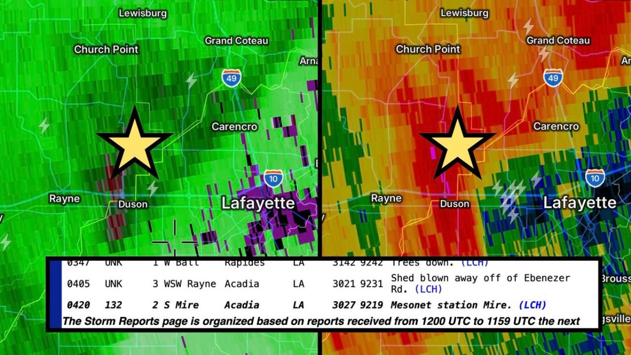
The report, logged around 2 miles south of Mire near Duson and the Lafayette Parish border, initially indicated a 132 mph gust attributed to a “mesonet” station. However, closer inspection of radar data and station availability is casting serious doubt on the validity of that reading.
No Confirmed Mesonet Station in Mire
One of the first concerns involves the source of the report. The entry lists the gust as coming from a mesonet station in Mire. However, the University of Louisiana Monroe does not operate a mesonet station in Mire, raising questions about how the data was collected and verified.
Meteorologists reviewing the situation believe the 132 mph figure may have been:
- Misreported in kilometers per hour instead of miles per hour
- Entered incorrectly by a local resident
- Mistakenly classified as a mesonet observation
If the original value was 132 km/h, that would convert to approximately 82 mph, which aligns much more realistically with observed storm conditions.
Radar Shows Rotating Kink, But No Debris Signature
Radar imagery from the Lake Charles radar site showed a rotating “kink in the line” circulation moving through the broader Lafayette region. While embedded rotation was present within the squall line, analysts did not observe a debris signature — which would typically be expected with a tornado strong enough to produce 132 mph winds.
Additionally, the tightest radar-indicated rotation appeared to track south of Duson, not directly near Mire. That places the most concentrated rotation roughly 4 to 5 miles away from where the extreme gust was reported.
Without corroborating radar evidence, a violent tornado producing 132 mph winds in that specific location appears highly unlikely.
Could It Have Been a Microburst?
Some consideration was given to whether a powerful microburst could have produced such an extreme wind reading. Mire would theoretically be in a favorable position for a wraparound microburst north of the main circulation.
However, meteorologists note that a microburst producing 132 mph winds would be exceptionally rare — rivaling some of the strongest microbursts ever recorded in the United States.
For context:
- The well-documented 151 mph microburst at Andrews Air Force Base in Maryland (August 1, 1983) remains one of the most intense ever measured.
- A 132 mph microburst in Acadia Parish would be historically significant and likely produce widespread, catastrophic damage.
Reports from the area do not indicate that level of destruction.
More Likely Scenario: 70–80 MPH Straight-Line Winds
Given the radar structure, environmental conditions, and lack of debris signature, forecasters are leaning strongly toward the explanation that the region experienced 70 to 80 mph straight-line winds, which were then misreported as 132 mph.
Supporting details include:
- Documented reports of trees down near Rayne
- A shed blown away off Ebenezer Road
- Widespread but not catastrophic wind damage
These impacts are consistent with severe thunderstorm winds in the 70–80 mph range — strong enough to cause structural damage and down trees, but far below violent tornado or extreme microburst levels.
Why Verification Matters
Extreme wind reports carry significant weight. A confirmed 132 mph gust would imply:
- Tornado-strength winds
- Potential EF3-equivalent damage
- A historically significant severe weather event
Because of that, meteorologists are careful to verify such readings against:
- Radar signatures
- Official weather station networks
- Ground damage surveys
- Consistency with surrounding reports
In this case, the available evidence does not support a 132 mph event near Mire.
Location Details
The questionable report originated in:
- Mire, Acadia Parish, Louisiana
- Just north of Duson
- Near the Lafayette Parish boundary
- West of Lafayette
The broader storm line moved through southwest Louisiana with embedded rotation, but impacts appear consistent with strong severe thunderstorm winds rather than a violent tornado or extreme microburst.
At this time, forecasters are leaning toward the 132 mph gust being spurious or erroneous, likely stemming from a reporting or unit conversion mistake. The more probable scenario remains damaging straight-line winds in the 70–80 mph range.
WaldronNews.com will continue monitoring for any official clarification or storm survey updates from the National Weather Service regarding the Mire, Louisiana wind report.