
40–50kt Low-Level Jet Targets Kansas and Oklahoma Friday as Potent Warm Sector Fuels Severe Storm Setup Across Central Plains
UNITED STATES — A strengthening severe weather setup is taking shape for Friday across the Central Plains, with forecast models highlighting a widespread 40–50 knot low-level jet, steep lapse rates, and height falls spreading across much of the warm sector — ingredients that could support organized severe thunderstorms from Kansas into Oklahoma.
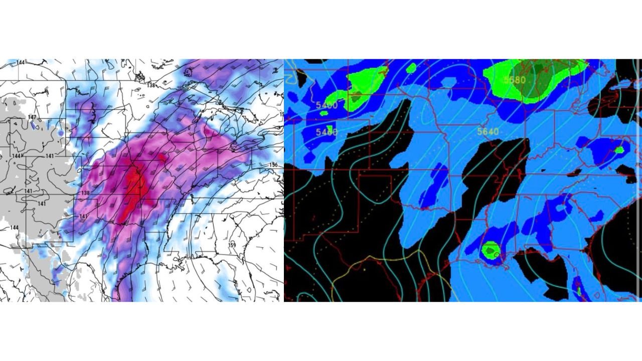
Forecast guidance valid Friday evening (March 6) shows an energetic upper-level trough digging into the western United States while stronger southwest flow overspreads the Plains.
Strong Dynamics Coming Together
Key atmospheric signals shown in the latest model data include:
- 40–50 kt low-level jet (LLJ) developing across Kansas and Oklahoma
- Strong mid-level flow (noted in 500mb wind fields)
- Height falls spreading eastward into the warm sector
- Increasing instability across the southern and central Plains
The strengthening low-level jet will enhance moisture transport northward from Texas into Oklahoma and Kansas, while also increasing wind shear — a critical ingredient for organized severe storms.
Warm Sector Focus: Central Kansas into Central Oklahoma
The warm sector — the unstable air mass ahead of the advancing trough — appears centered from:
- Central Kansas
- Eastern Kansas
- Western and Central Oklahoma
- Possibly into North Texas
Model guidance shows strong mid-level winds overspreading this region during peak heating hours Friday afternoon and evening.
If sufficient instability develops, storms could organize quickly.
Trough Shape Still a Question Mark
One major uncertainty remains the exact shape and progression of the upper trough.
Ensemble guidance suggests:
- Some model spread still exists
- The trough may deliver more of a “glancing blow” to southern areas
- Convective precipitation signals are not uniformly robust across all guidance
If the trough axis sharpens and slows, severe potential could increase. If it lifts northeast faster, some southern areas may see a more limited response.
This remains something forecasters are closely monitoring.
Height Falls Signal Lift
Height change maps show notable falls spreading across the Plains — a sign of large-scale lift increasing ahead of the trough.
That lift combined with:
- Strong shear profiles
- Favorable lapse rates
- Moisture return via the LLJ
Creates a conditional but potentially impactful severe weather setup.
Storm Mode Considerations
With strong wind fields present at multiple levels:
- Discrete supercells could develop initially
- Storm clusters or a line may evolve later
- Damaging winds and hail appear possible
- Tornado risk will depend on how instability and boundary interactions evolve
Details will hinge on mesoscale factors that won’t be fully resolved until closer to Friday.
What This Means for Arkansas
While the highest severe signal currently appears centered west of Arkansas, the broader pattern indicates:
- Increasing cloud cover late week
- Potential showers or storms spreading east
- Strong gradient winds possible as the system approaches
Residents in western Arkansas should remain weather-aware as forecast refinements continue.
Bottom Line
Friday has clear severe weather potential across the Central Plains, especially from Kansas into Oklahoma, with strong wind shear and dynamic support in place.
However, uncertainty in trough evolution and convective response keeps this forecast conditional for now.
Stay with WaldronNews.com for the latest forecast updates as we refine timing, severity expectations, and any local impacts for Arkansas and surrounding states.