
700mb “Slider” Storm Tracks North, Bringing Light Precipitation Risk to Southern New England Including Connecticut, Rhode Island and Eastern Massachusetts
UNITED STATES — A developing storm system featuring a 700mb low positioned farther north than earlier projections is increasing the likelihood that parts of southern New England will see light precipitation as it moves east.
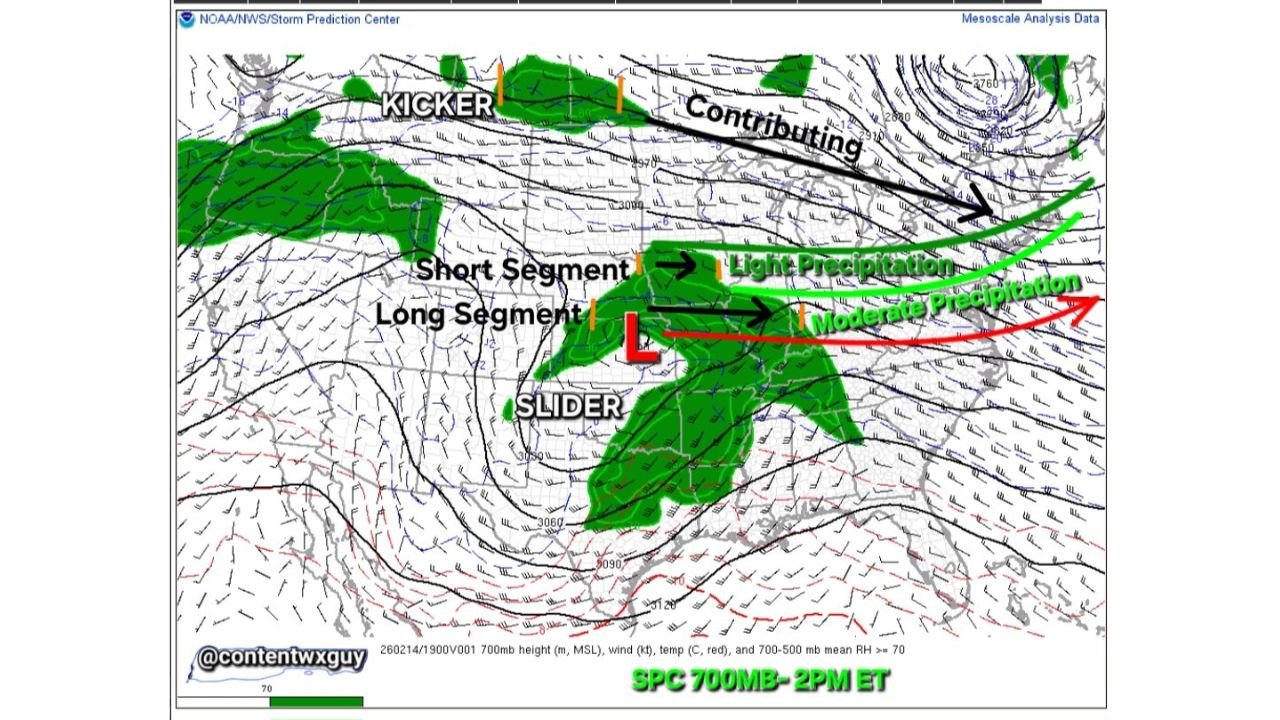
Mesoscale analysis from the Storm Prediction Center shows a compact mid-level low — often referred to as a “slider” system — tracking across the Midwest and into the Northeast. While not a major storm, subtle shifts in its placement are making a difference for areas from Connecticut and Rhode Island into eastern Massachusetts.
Northern 700mb Low Expands Moisture Reach
The key feature in this setup is the 700mb low center, which is positioned somewhat north of earlier expectations. That adjustment allows a short but important segment of mid-level moisture to arc into southern New England.
Analysis highlights:
- A “short segment” of moisture extending east-northeast
- Increasing 700–500mb relative humidity
- Light precipitation potential spreading into southern New England
Because this moisture ribbon is relatively narrow, precipitation coverage will likely be spotty and light rather than widespread and heavy.
The Role of the “Kicker” System
Upstream, a secondary disturbance — labeled as a “kicker” — is moving east across the northern Plains and Great Lakes.
Earlier concerns suggested this kicker might suppress the main system farther south. However, current trends show:
- The kicker moving slightly slower
- Less suppressive influence on the primary low
- Additional moisture support feeding into the broader pattern
That subtle timing difference allows southern New England to remain close enough to the northern edge of the moisture field to see light precipitation.
Light vs. Moderate Precipitation Axis
The heaviest precipitation associated with this system remains displaced farther south and east of the 700mb low track.
Model guidance indicates:
- Moderate precipitation focused farther southeast
- Light precipitation extending north into southern New England
For areas including Hartford, Providence, Boston and surrounding communities, this likely means lighter totals rather than a significant event.
What Southern New England Can Expect
If current trends hold, residents in:
- Connecticut
- Rhode Island
- Southeastern Massachusetts
could see periods of light precipitation as the system passes.
Because the moisture plume is relatively shallow and short-lived, this is not expected to produce major impacts. Instead, it appears to be a modest event supported by mid-level dynamics rather than a fully developed coastal storm.
Why Small Mid-Level Shifts Matter
At 700mb (roughly 10,000 feet above the surface), small changes in low placement can dramatically alter:
- Moisture transport
- Precipitation coverage
- North-south rain or snow boundaries
In this case, the northward position of the mid-level low allows just enough moisture to reach southern New England, while areas farther north may remain largely dry.
A Limited but Notable Event
This system does not appear to have the structure or support for widespread heavy precipitation in New England. However, the evolving dynamics underscore how even subtle upper-level adjustments can alter local impacts.
Southern New England residents should monitor updates, particularly if additional moisture support develops or if the kicker’s timing shifts further.
WaldronNews.com will continue tracking the slider system and any adjustments that could affect Connecticut, Rhode Island and eastern Massachusetts as the storm progresses eastward.