
Arctic Air Set to Unleash Repeated Cold Blasts Across the Midwest, Ohio Valley, and Northeast as Forecast Shows Temperatures Plunging Well Below Normal
UNITED STATES — Weather models show a series of powerful Arctic air outbreaks poised to sweep across the High Plains, Midwest, Ohio Valley, Mid-Atlantic, and Northeast over the next 7–10 days, bringing widespread temperature drops and multiple opportunities for wintry impacts.
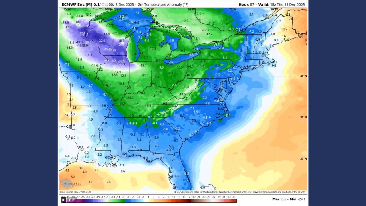
New animated model guidance and temperature anomaly maps reveal that repeated cold surges will push deep into the eastern half of the country, setting up a prolonged stretch of below-normal temperatures as December heads toward Christmas week.
Forecasters say the persistent blue and purple shading seen on the newest maps is a clear signal of strong, lasting cold air, while warmer-than-normal conditions hold across the West.
Model Shows a Steady Stream of Cold Air Pushing South
Weather graphics from the ECMWF ensemble model show a dynamic jet stream pattern diving from Canada into the central and eastern U.S., carrying fresh waves of Arctic air.
One meteorologist summarized it simply:
“There will be no shortage of cold blasts across the High Plains, Midwest, Ohio Valley and Mid-Atlantic/Northeast over the next 7–10 days.”
The model imagery indicates:
- Deep troughing over the central and eastern U.S.
- Repeated northwest flow, ideal for cold advection
- A storm track favoring Great Lakes snow and coastal disturbances
- Strong temperature drops following each passing system
This pattern signals a sustained cold regime that could anchor itself for much of December.
Coldest Air Targets Midwest Through Northeast
The temperature anomaly maps show double-digit negative departures from normal across a large portion of the eastern United States — especially the Upper Midwest, Great Lakes, Pennsylvania, New York, New England, and the Mid-Atlantic.
Deep purple shades over states like Michigan, Ohio, and New York indicate:
- 10–20°F below normal temperatures
- Increased risk of lake-effect snow
- Colder-than-normal mornings and wind chills
- Potential travel impacts when moisture aligns with Arctic air
Even the Southeast will see cooler-than-normal air pushing in periodically, though not as intense as farther north.
Meanwhile, The West Stays Much Warmer Than Normal
As the East battles intruding Arctic air, the western half of the country — particularly California, Nevada, Utah, Arizona, and parts of the Pacific Northwest — continues under a stubborn warm pattern.
Recent outlooks show strong above-normal temperature probabilities, suggesting:
- A warm ridge remaining anchored over the West
- Lower chances for early-season snowfall
- An amplified temperature contrast stretching coast to coast
This sharp divide will play a key role in determining storm development between the cold East and warm West.
Could Christmas Week Bring a Warm-Up?
The meteorologist behind the analysis hinted that some regions might catch a break:
“Maybe the week of Christmas a warm-up for some…”
Long-range signals suggest that while the cold pattern dominates through mid-December, slight moderation may arrive right before the holiday in parts of the Midwest or Mid-Atlantic.
However, forecasters warn that any warm-up would be temporary, as the broader pattern still favors more cold intrusions heading into late December and early January.
A Recurring Winter Theme Taking Shape
Combined with earlier outlooks showing expanding cold probability zones, this new data reinforces a likely trend for Winter 2025:
- Persistent cold across the central and eastern U.S.
- Warmer, drier conditions across much of the West
- Frequent temperature swings separated by sharp frontal boundaries
- Increased risk of snow systems in the Great Lakes and Northeast
Meteorologists expect the cold pattern to be recurrent, driven by upper-air dynamics that are not likely to shift quickly.
How will this extended cold pattern impact your holiday travel and daily routine? Share your thoughts and get the latest winter updates anytime at WaldronNews.com.