
Two Alberta Clipper Systems to Bring High Winds, Snow, and Dangerous Travel Conditions Across Montana, North Dakota, Minnesota, and Michigan Through Dec. 10, Forecasters Warn
UNITED STATES — A pair of fast-moving Alberta Clipper systems are sweeping across the northern United States this week, bringing high winds, accumulating snow, and hazardous travel conditions from Montana to Michigan. The National Weather Service warns that impacts will continue Monday through Wednesday (Dec. 8–10) as both storm systems race across the region.
Clipper systems—known for their speed and sharp temperature drops—are expected to deliver narrow bands of snow, areas of blowing and drifting, and potential whiteout conditions, especially across the High Plains and Upper Midwest.
Fast-Moving Storms Begin in Canada Before Racing Southward
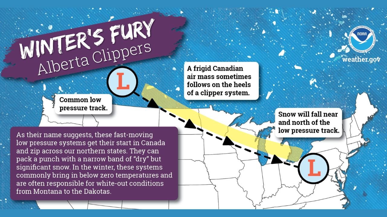
As NOAA graphics show, Alberta Clippers originate in western Canada and travel southeast across the northern tier of the U.S. at high speed. While typically moisture-limited, they can still bring impactful snowfall along and north of the low-pressure track.
Meteorologists note:
“High winds, accumulating snow, and icy conditions are expected across a number of states from Montana to Michigan due to two different Alberta Clipper systems.”
These systems are notorious for producing quick but disruptive winter weather events, often catching travelers off guard.
Where the Snow Will Hit the Hardest
The heaviest snow is expected near and north of the low-pressure track, a classic signature of clipper-driven systems.
States under the highest risk include:
- Montana
- North Dakota
- South Dakota
- Minnesota
- Wisconsin
- Michigan
The combination of fresh snowfall and strong wind gusts may create pockets of treacherous road conditions, especially in open rural areas.
NOAA warns that a frigid Canadian air mass may follow behind each clipper, potentially sending temperatures below zero in parts of the Dakotas and northern Minnesota.
Why Alberta Clippers Pack a Bigger Punch Than Expected
Despite often carrying less moisture than larger winter storms, these clippers remain dangerous due to:
- Rapid speed, limiting forecasting windows
- Cold, dry air, producing powdery snow that blows easily
- Sudden wind shifts, reducing visibility in seconds
- Sub-zero temperatures, increasing frostbite risk for anyone outdoors
NOAA’s educational graphic explains that clipper systems “can pack a punch with a narrow band of ‘dry’ but significant snow,” particularly when they drop south of the U.S.–Canadian border.
Timing: Two Clipper Waves in Three Days
Forecasters expect:
Clipper #1:
- Moving across the northern Rockies and Dakotas
- Producing light to moderate snow
- Spreading wintry conditions eastward into Minnesota and Wisconsin
Clipper #2:
- Following shortly behind
- Likely stronger
- Capable of higher wind gusts and sharper temperature drops
- Extending impacts eastward into Michigan and northern Ohio
Snowfall amounts will remain moderate overall, but blowing snow and ice may be the most dangerous component.
Travelers Urged to Prepare for Rapid Weather Changes
Because clipper systems move so quickly, weather conditions can deteriorate within minutes, not hours. Motorists are advised to monitor updated alerts, reduce speeds, and watch for drifting snow on rural highways.
Residents in the northern U.S. should also prepare for:
- Brutally cold wind chills
- Icy spots on untreated roads
- Disrupted visibility during peak gusts
- Potential school delays or power-line issues
Forecasters note that winter weather patterns appear increasingly active as December progresses.
How will these fast-moving clippers affect your holiday travel or workweek plans? Stay ahead of every winter alert with the latest updates only on WaldronNews.com.