
Upper-Air Pattern Shift May Bring Winter Trough Toward the Plains as Christmas Week Forecast Trends Evolve Across the United States
UNITED STATES — A major upper-air pattern developing over North America could influence Christmas week weather across the central and eastern United States, according to new long-range ensemble guidance. While early projections strongly favored a widespread warm pattern heading into the holiday, the latest 500mb height anomaly maps suggest a possible shift that forecasters say cannot be ignored.
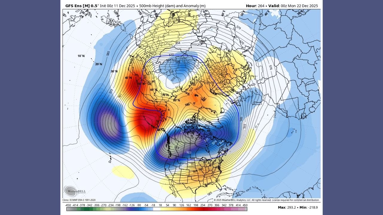
Ensemble Data Shows a Dominant Ridge-West / Trough-East Setup
Fresh model output from the GFS Ensemble highlights a large and persistent positive height anomaly over the eastern Pacific, marked by deep reds indicating strong ridging. This ridge forces the jet stream northward before bending sharply downward across Canada and the central U.S., creating a broad trough over eastern Canada and the Upper Midwest.
The trough is defined by strong negative height anomalies, with deep blues surrounding Hudson Bay extending south into the northern Plains. This colder core of upper-level energy is what long-range meteorologists are watching closely as the pattern evolves approaching December 20–25.
Why This Pattern Matters for Christmas Week
Earlier ensemble runs from the European, American, and AI-driven models unanimously pointed toward a “torch pattern”—a widespread warm anomaly across much of the country for Christmas week. But meteorologists are cautioning that patterns like the one now appearing often backpedal, especially when ridging in the northeast Pacific intensifies.
A strong ridge of this type can cause wavelengths to shorten, which may allow the trough to tilt, deepen, or rotate farther into the central U.S. If this happens, the holiday forecast could shift toward cooler and more active weather for parts of the Plains and Midwest.
At this stage, ensemble agreement remains mixed, meaning large-scale uncertainty still dominates the late-December outlook.
What the Current Map Shows
The new ensemble map indicates:
- Strong ridging off the West Coast, extending toward Alaska
- A deep and broad trough centered over eastern Canada
- Jet stream alignment favoring potential southward transport of colder air
- A possible corridor for storm development if the trough shifts into the Plains
The setup does not guarantee a winter storm, but it does create a synoptic environment supportive of significant pattern changes right before Christmas.
Could This Lead to a Christmas Storm?
Meteorologists emphasize that it is too early to confirm any specific storm signal. However, when a ridge this strong develops over the Pacific, it often acts as a “traffic director” that can:
- Steer colder air into the central U.S.
- Open the door for moisture return from the Gulf
- Enhance jet stream energy supporting storm formation
If the trough shifts farther southwest than currently projected, the Plains and Midwest could see a more winter-like holiday period than early models suggested.
Uncertainty Remains High, But the Trend Is Worth Watching
Despite the potential change, the warm signal has not disappeared. Many ensemble members still support above-average temperatures east of the Rockies, especially in the Southeast and Mid-Atlantic.
But having a pattern this amplified—combined with a ridge of this magnitude—means rapid forecast swings are possible over the next 7–10 days.
Meteorologists describe this as a “volatile pattern window,” where small shifts in upper-air features can dramatically change surface weather outcomes.
Bottom Line
- A strong Pacific ridge and Canadian trough could modify the Christmas week warmth.
- A colder trend is possible if the trough shifts into the Plains between December 20–25.
- No specific storm is forecast yet, but the pattern is one that has historically produced major holiday weather events.
WaldronNews.com will continue monitoring ensemble trends and model shifts daily as holiday travel week approaches.
Stay tuned for updates from WaldronNews.com as this evolving pattern becomes clearer.