
Connecticut, New York City and Long Island Expected to See 1–3 Inches of Fluffy Snow in Saturday Night Storm
CONNECTICUT AND NEW YORK – A compact weekend storm is lining up to bring the first widespread 1–3 inches of fluffy snow to parts of coastal Connecticut, New York City and Long Island from late Saturday night into early Sunday morning, forecasters say.
A Classic Light Snow Event, Not a Major Nor’easter
This system is shaping up as a “good old-fashioned light snow event” rather than a high-impact winter storm. Current guidance shows no rain and no wintry mix for the core of the region once precipitation sets in Saturday night. Instead, the atmosphere should be cold enough to support all snow, with relatively light winds and modest moisture.
Because the storm is fast-moving and not especially strong, snowfall amounts are expected to remain on the order of 1–3 inches for most communities, with the higher totals favored near the shoreline.
Timing: Late Saturday Night Through Sunday Morning
The latest runs of the European and American models focus the main snow window between midnight and 7 a.m. Sunday:
- Flurries or light snow may begin to break out late Saturday evening, especially west of New York City.
- Steadier snow is most likely after midnight, peaking in the pre-dawn hours.
- By mid-morning Sunday, most guidance has the system sliding offshore, with only leftover flurries or clouds behind it.
That means many residents could wake up to a fresh coating of snow Sunday, with roads gradually improving through the day as crews treat and temperatures hover near or just below freezing.
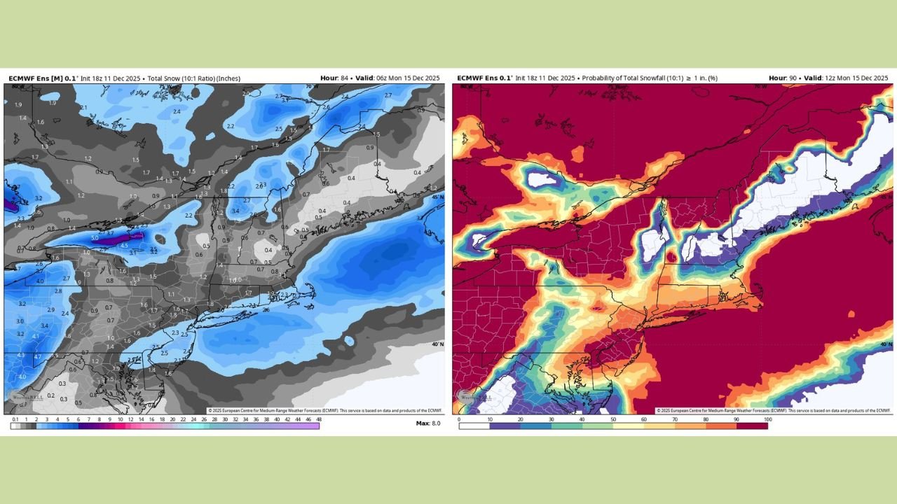
Model Guidance: European Favors 1–3 Inches, GFS More Conservative
Meteorologists are paying close attention to the European ensemble model, which currently shows a 70–80% chance of at least 1 inch of snow across much of Connecticut, New York City and Long Island, and localized odds for over 2 inches along the coast.
The GFS model remains more cautious, suggesting a coating to around an inch for many inland spots. However, given the projected track of the wave and how consistently the European data have handled this setup, many forecasters are leaning toward the 1–3 inch range about 48 hours out from first flakes.
Who Has the Best Chance for Higher Totals?
The shoreline and coastal communities currently appear to have the best odds of reaching the 2–3 inch range, including:
- Coastal Connecticut from roughly New Haven eastward
- New York City and nearby suburbs
- Long Island, especially central and eastern sections
Farther inland across interior Connecticut, the lower Hudson Valley and northern New Jersey, the storm may be just a bit weaker, with totals closer to 1–2 inches more typical.
Even so, this could still qualify as the first “real” snow of the season for many along the I-95 corridor.
Travel and Impact: Mostly Minor but Slippery
While this is not expected to be a blockbuster storm, impacts could still be felt on roads and sidewalks, especially where snow falls during the overnight hours:
- Untreated surfaces may become slick and snow-covered before sunrise Sunday.
- Bridges and overpasses could ice up quickly under bursts of moderate snow.
- Visibility may briefly drop during any heavier band, particularly along the coast.
Because winds look relatively light and the snow fairly dry and fluffy, major power outages or tree damage are not expected with this event.
What Could Still Change
With about two days to go, small shifts in the storm track could nudge the snow band north or south, changing who sees the higher totals. If the wave tracks farther offshore, amounts would trend lower; if it hugs the coast more tightly, coastal communities might overperform current projections.
Residents should keep an eye on updated forecasts Friday and Saturday in case advisories are issued for slick travel.
As this light but potentially slick snowmaker approaches, WaldronNews.com will continue to monitor new model runs and local forecasts. Check back often for updated snowfall maps, timing details, and any last-minute changes that could affect travel across Connecticut, New York City and Long Island this weekend.