
Maryland and Pennsylvania Snow Forecast: I-95 Corridor from Baltimore to Philadelphia Could See 2–4 Inches in Early-Sunday Burst
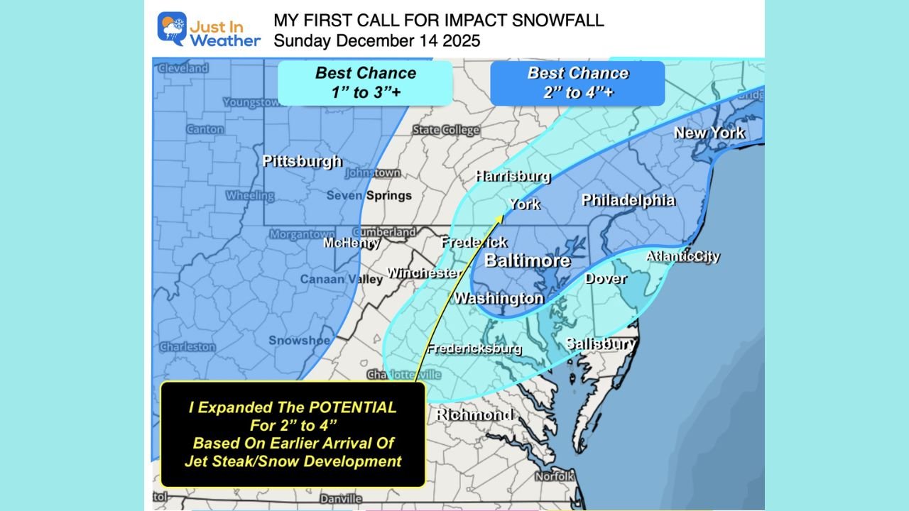
BALTIMORE, MARYLAND – A quick-hitting winter system is lining up to bring the first meaningful snow of the season to parts of Maryland, Pennsylvania, Delaware, New Jersey and New York early Sunday, December 14. Current guidance points to a light but focused band of 1–3 inches of fluffy snow, with a “sweet spot” of 2–4 inches possible near and just northwest of the I-95 corridor from Baltimore to Philadelphia.
Overview: A Classic Light Snow Event for the Mid-Atlantic
Forecasters are tracking a compact disturbance sliding in on the backside of this week’s Arctic pattern. The latest European (ECMWF) model appears to have the best handle on the storm’s dynamics, while the GFS has tended to push the snow band farther south and the Canadian model has run too warm and north.
Putting those pieces together, the most likely outcome right now is a general 1–3 inches of powdery snow from western Maryland and northern West Virginia through central Pennsylvania and into New Jersey, with slightly higher totals in a narrow zone from York, Pennsylvania, to Baltimore, Maryland, and up toward Philadelphia.
Jet-Stream Punch Will Help the Snow Burst Develop
One of the key features with this system is a powerful jet streak of more than 100 knots (around 115 mph) at about 18,000 feet racing overhead early Sunday.
That jet streak will enhance rising motion in the atmosphere, allowing a relatively weak surface wave to produce a sharper burst of snow than its size might suggest. Where that upper-level energy lines up with the surface low is where the heaviest 2–4 inch totals are most likely.
Best Chance for 2–4 Inches: Baltimore–Washington to Philadelphia and Coastal New Jersey
Based on the latest snowfall projections:
- 1–3 inches: Western Maryland, northern West Virginia, much of central Pennsylvania, northern Delaware, interior New Jersey and parts of southern New York state.
- 2–4 inches or a bit more in spots: A corridor from near Washington and Baltimore northeast through York and Harrisburg into the Philadelphia metro and portions of coastal New Jersey, Long Island and coastal Connecticut.
If the snow band develops a few hours earlier than some models show, more of southern Pennsylvania and northern Maryland between York and Philadelphia could be pulled into the higher-end totals.
Timing: Main Snow Window Between 2 a.m. and 10 a.m. Sunday
Right now, the primary impact window runs from roughly 2 a.m. to 10 a.m. Sunday.
- Pre-dawn hours (2–5 a.m.) – Snow begins west of I-95 and quickly expands east.
- Around sunrise (5–8 a.m.) – Snow rates could briefly reach 1 inch per hour in the “sweet spot” near I-95 from Baltimore to Philadelphia as the strongest jet-stream lift passes overhead.
- Mid-morning (8–10 a.m.) – Snow band slides east, tapering off from west to east with lingering light snow or flurries.
Because temperatures will be cold, roads could become slick quickly, especially on untreated surfaces, ramps and secondary streets.
Impacts: Light Totals but Slippery Travel and First Real Snow for Many
While this looks like a relatively low-impact event in terms of total accumulation, it may still create hazardous travel for a few hours, particularly:
- Along I-95 between Baltimore, Maryland, and Philadelphia, Pennsylvania, where heavier bursts could drop a quick couple of inches.
- On bridges and overpasses, which often freeze first.
For many communities along the Mid-Atlantic coast — including coastal Connecticut, New York City, Long Island, and coastal New Jersey — this could be the first real accumulating snow of the season.
Uncertainty and What Could Still Change
As with any clipper-style system tied to a strong Arctic pattern, small changes in timing or track can make a big difference:
- A slightly earlier arrival of the jet streak and surface wave could expand the 2–4 inch zone farther southwest into more of Maryland and Pennsylvania.
- A weaker or later-arriving wave would mean closer to a coating to 1 inch in some areas, especially south of the main band.
Forecasters will continue to compare model snow maps and the National Blend of Models and make adjustments as newer data arrives.
Stay with WaldronNews.com through the weekend for updated snow maps, timing graphics and any school or travel advisories. If you experience snow in your neighborhood Sunday morning, share your total and location so we can help keep the region informed.