
Maryland and Northern Virginia Face Light to Moderate Snowfall Risk as NWS Tracks Developing Weekend System
MARYLAND — A developing winter system is expected to bring light to moderate snowfall across Central and Northeast Maryland, with lighter accumulations extending into Northern Virginia and the Washington, D.C. region between Friday night, December 12, and Monday, December 15, 2025.
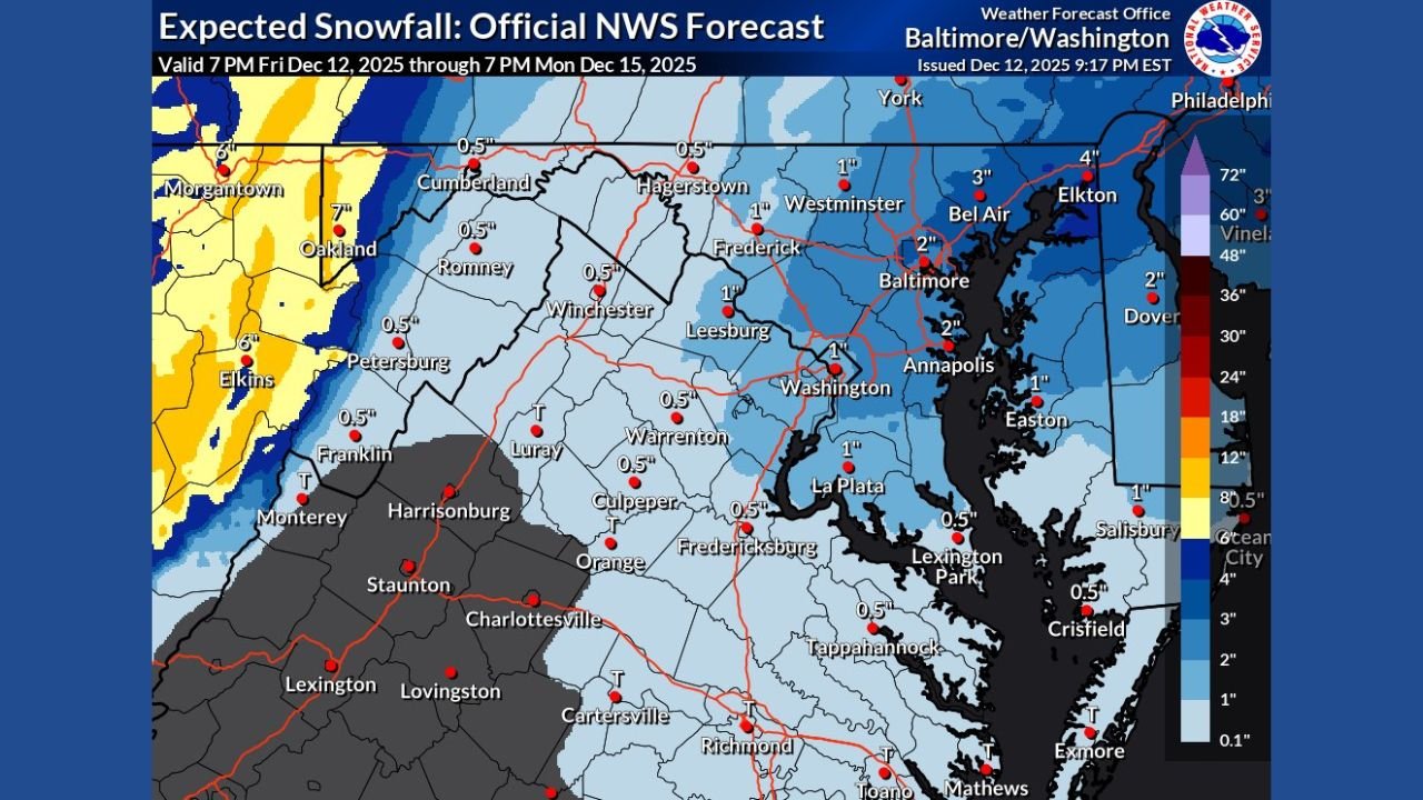
According to the National Weather Service’s latest snowfall forecast issued at 9:17 PM EST, exact totals are still evolving, but current projections keep the Washington, D.C. area on the lower end, while Maryland remains in the higher-impact zone.
Early Forecast Shows Lower Snow Amounts Near Washington, D.C.
The National Weather Service has not issued any winter weather advisories yet, largely because expected totals around Washington, D.C. remain around the 1-inch mark.
Forecasters note that advisory-level snowfall typically requires a range closer to 2–4 inches, particularly outside of weekday rush-hour windows.
For now, D.C. and nearby suburbs are forecast to see:
- 0.5″ to 1″ across Washington, Alexandria, Arlington, and parts of Fairfax County
- Around 1″ possible in areas such as Leesburg, Frederick, and Annapolis
- Lighter dustings toward Southern Maryland and the Northern Neck region of Virginia
Maryland Likely to See the Heaviest Snowfall
While totals are modest farther south, Central and Northeast Maryland currently have the best chance for accumulating snowfall, based on tonight’s model trends.
NWS projections show:
- 3″ to 4″ possible near Elkton and areas along the upper Chesapeake Bay
- 2″ to 3″ in Bel Air and northern Baltimore County
- 1″ to 2″ for Baltimore City, Westminster, and Dover
- 1″ around Annapolis and eastern portions of Howard County
These areas lie within a slightly stronger snowfall band that may set up as the system organizes. However, forecasters caution that the exact placement of this heavier band may not be known until very close to snow onset.
Northern Virginia Trends Lower as Models Shift South and East
Across Northern Virginia — including Leesburg, Fairfax, Winchester, and Culpeper — today’s model trends have shifted downward, leaving most communities with:
- 0.5″ to 1″ of snow
- Trace amounts in areas farther southwest such as Harrisonburg, Staunton, and Charlottesville
This reduction in snowfall probabilities is part of a broader trend where the developing system is tracking slightly north and east, placing Maryland in a more favorable position for accumulating snow.
Timing and Travel Considerations
The snowfall window covers Friday evening through Monday, though the heaviest and most organized precipitation is expected late Saturday into Sunday.
Residents should expect:
- Light, steady snow for much of the region
- Possible slick travel during overnight hours
- Heavier localized bands across Central and Northeast Maryland
Road impacts in the D.C. metro area will likely be limited, unless the snow band shifts farther south than currently projected.
WaldronNews.com will continue to monitor National Weather Service updates as the system approaches. Stay tuned for updated snowfall totals, advisory announcements, and additional forecast adjustments.