
Pennsylvania Braces for Early-Season Snow as Weekend Storm Track Remains Uncertain, With 1–4 Inches Possible
PENNSYLVANIA — A developing winter system expected to move across the Mid-Atlantic on Sunday, December 14, 2025, may bring Pennsylvania its first meaningful snowfall of the season, though final amounts depend heavily on how the upper-level storm system evolves.
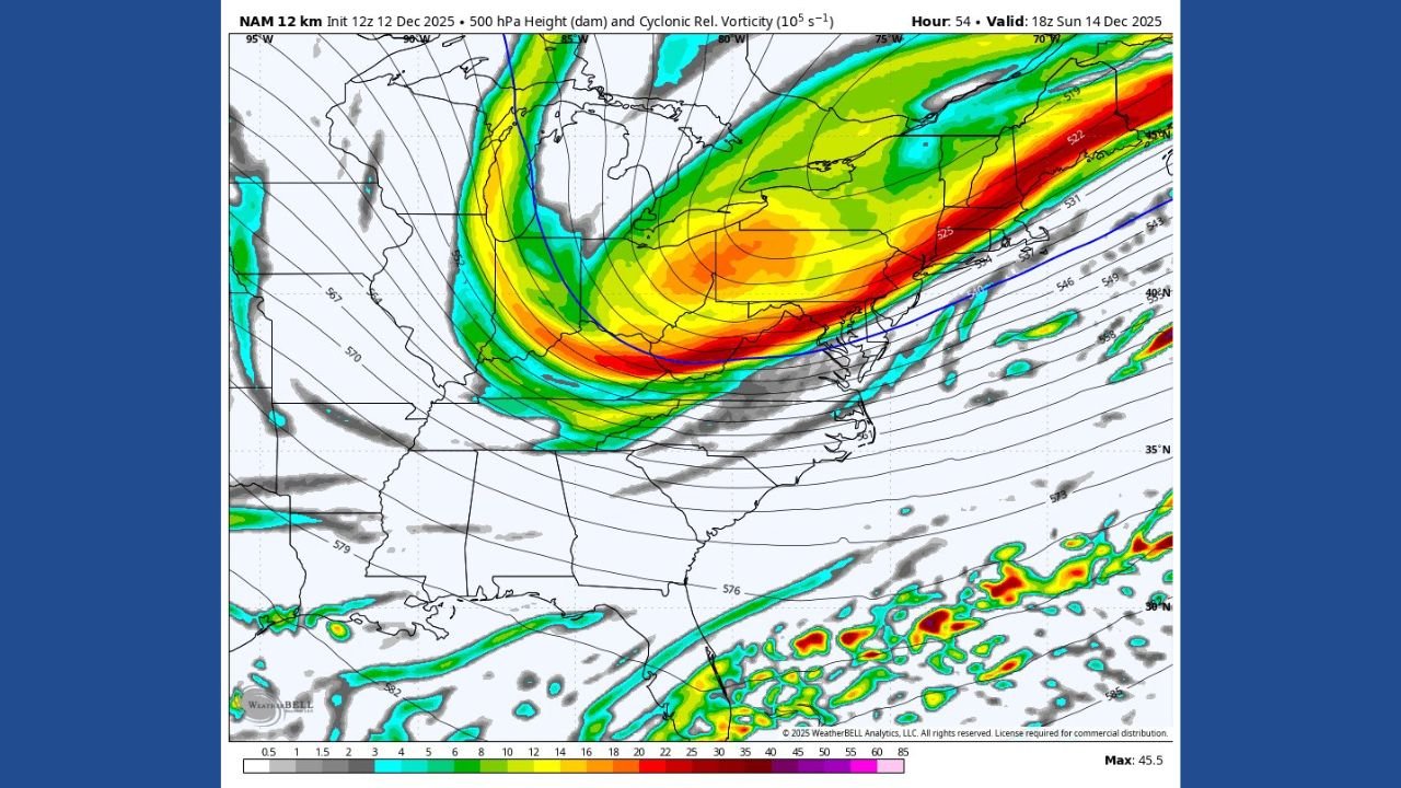
New NAM and RGEM model runs from December 12 show major differences in the tilt of the incoming trough, creating a wide range of possible snowfall outcomes across central and southern Pennsylvania.
Model Differences Could Shift Pennsylvania Into Either a Light or Moderate Snow Event
Meteorologists note that the two primary models — NAM and RGEM — are showing very different solutions, which is why snowfall ranges remain broad.
NAM Model (Lower Snow Scenario)
- Shows a more positively tilted trough, stretching southwest to northeast.
- This configuration reduces atmospheric lift.
- Pennsylvania sees lighter, more scattered snowfall.
RGEM Model (Higher Snow Scenario)
- Displays a more neutrally tilted trough, strengthening storm organization.
- Allows the snow shield to expand farther north and east.
- Increases the chance of 2–4 inches of snow, especially for southern and southeastern Pennsylvania.
Forecasters say this difference will determine whether Pennsylvania receives just a 1–2 inch light event, or a broader 2–4 inch accumulation across many communities.
Southern and Southeastern Pennsylvania Most Favored for Accumulation
Early projections indicate that:
- York, Lancaster, Reading, and Philadelphia suburbs may sit near the higher end of the possible snowfall if the RGEM scenario verifies.
- Harrisburg, Lebanon, and Chambersburg could fall into a 1–3 inch range depending on band placement.
- Northern Pennsylvania likely sees lighter totals, with the better dynamics staying farther south.
Model graphics show the main energy axis sweeping just south of Pennsylvania, placing the state on the northern edge of the snow shield, where small shifts can lead to big forecast changes.
Sunday Remains The Critical Window
The developing trough will swing through on Sunday afternoon into evening, and the way it tilts in real-time will dictate:
- Where the heaviest band sets up
- How far north the snow expands
- Whether totals stay light or trend toward 3–4 inches in parts of Pennsylvania
Forecasters say confidence will improve within 24 hours, as short-range models begin resolving the storm track more clearly.
First Accumulating Snow Likely for Many Pennsylvania Communities
While not a major winter storm, this system may bring:
- Slippery roads
- Reduced visibility during heavier bursts
- The first measurable snow of the 2025–2026 season for parts of the state
Drivers should plan for slower travel Sunday evening, especially in southern and southeastern counties.
WaldronNews.com will continue tracking snowfall maps, updated model runs, and National Weather Service advisories as the system approaches.