
Ohio Winter Storm Expected to Bring 5–9 Inches of Snow Across the Ohio Valley, With Significant Accumulations Extending Into Indiana, West Virginia, and Pennsylvania
OHIO — A developing winter storm is forecast to sweep across the Ohio Valley today, bringing widespread snowfall of 5–9 inches to parts of Ohio, Indiana, West Virginia, and Pennsylvania.
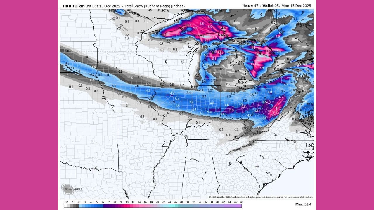
According to the latest high-resolution HRRR model run (06z, December 13), a long, concentrated snowband is expected to track across several states, producing the heaviest accumulations near central and eastern Ohio.
HRRR Model Shows a Well-Organized Snowband Across the Region
The HRRR 3 km snowfall projection (valid through early Monday, December 15) shows a clear corridor of moderate to heavy snow stretching from the Midwest into the central Appalachian region.
Key forecast highlights include:
- Ohio: Widespread totals of 5–7 inches, with pockets reaching 8–9 inches, especially in eastern and southeastern counties.
- Indiana: Central and eastern Indiana projected to receive 4–6 inches, with some locally higher totals toward the Ohio border.
- West Virginia: Northern counties positioned for 6–8 inches, with terrain-enhanced areas showing similar or slightly higher values.
- Pennsylvania: Western and southwestern portions, including areas near Pittsburgh, forecast to pick up 5–7 inches of accumulation.
The model indicates a well-defined snow axis, suggesting strong mid-level lift and steady precipitation rates throughout the event.
Ohio Valley Positioned for the Storm’s Core Impacts
Ohio appears to lie directly under the most persistent snowfall band, which explains the widespread 5–9 inch projections across the state.
Counties most likely to see higher totals include:
- Eastern Ohio
- Central Ohio
- Portions of southern Ohio
This area aligns with the deepest shading on the forecast map, indicating a prolonged period of accumulating snow.
Travel Hazards Expected as Snow Intensifies
With snow expected to fall steadily through the day and into the night, residents across the region should expect:
- Snow-covered highways
- Reduced visibility during heavier bursts
- Slippery secondary and untreated roads
- Slow travel conditions throughout the Ohio Valley
The HRRR snow-ratio calculation suggests typical, moderately fluffy snow, which can accumulate quickly.
Storm Timing
- Snow begins during the day today (Saturday).
- Heaviest snowfall expected this evening into overnight hours.
- Accumulations continue through early Monday morning, depending on location.
This timeline may vary slightly by region as the storm band shifts eastward.
First Significant Snowfall for Many Areas This Season
For much of Ohio, Indiana, West Virginia, and western Pennsylvania, this storm will serve as the first major snowfall event of December, delivering widespread totals well above typical early-season levels.
Residents are advised to monitor updated forecasts, especially as localized snowbands could cause higher-than-expected totals in narrow corridors.
WaldronNews.com will continue tracking this winter storm and provide updated snowfall projections as the system advances across the region.