
Texas, Oklahoma, Arkansas, and Louisiana Face Late-December Severe Weather Risk as Models Signal Potential Outbreak
TEXAS — Long-range weather forecast models are signaling a potential increase in severe weather risk across parts of Texas and neighboring states as December approaches its final stretch, raising early concerns about an unusually timed storm threat.
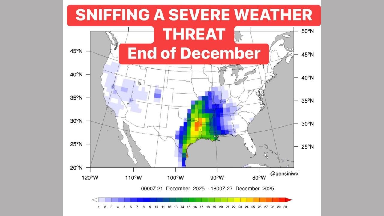
Forecast guidance suggests the most favorable window for organized storms could develop between December 20 and December 23, with some signals appearing as early as December 18, according to extended-range model data.
Why Forecasters Are Paying Close Attention
Multiple long-range ensemble models are beginning to highlight a developing corridor of severe weather potential stretching from the southeastern Great Plains into the Lower Mississippi River Valley.
“Long-range forecast models are hinting at an uptick in severe weather potential,” meteorologist Paul Dorian noted while reviewing the pattern.
While confidence remains limited at this distance, forecasters say the repeated appearance of this signal is enough to warrant early monitoring.
Atmospheric Setup Behind the Risk
The forecast pattern shows signs of a strong clash between warm, moisture-rich air from the Gulf of Mexico and incoming upper-level disturbances moving in from the west.
This type of setup is known to support:
- Strong to severe thunderstorms
- Damaging straight-line winds
- Large hail
- A conditional tornado threat
“It’s not a guarantee of severe weather, but the ingredients are beginning to line up,” forecasters caution.
Areas Most Likely to Be Impacted
Based on the model guidance shown in the provided data, the primary areas of concern currently include:
- Texas
- Oklahoma
- Arkansas
- Louisiana
The strongest signal is focused near the Lower Mississippi River Valley, where instability and wind shear may overlap most effectively if the pattern continues to develop.
Why the Timing Is Notable
Severe weather events do occur in December, but they are less common, which can increase risk due to reduced public awareness and preparedness.
“Late-season severe weather can catch people off guard,” meteorologists warn, emphasizing the importance of early awareness.
What Residents Should Do Now
Forecasters stress that this is not a confirmed outbreak, but rather an early signal that requires close monitoring.
Key points for residents:
- Forecast details will change over the coming days
- Confidence will increase as shorter-range models come into focus
- This is a time to review severe weather plans, not react immediately
Residents are encouraged to stay informed, especially those with holiday travel plans or outdoor activities planned during the December 20–23 timeframe.
WaldronNews.com will continue monitoring this developing weather pattern and provide updates as new data becomes available and forecast confidence improves.