
South Dakota, Minnesota and North Dakota Brace for Powerful 982-mb Cyclone as Near-100 mph Wind Gusts Slam the Region
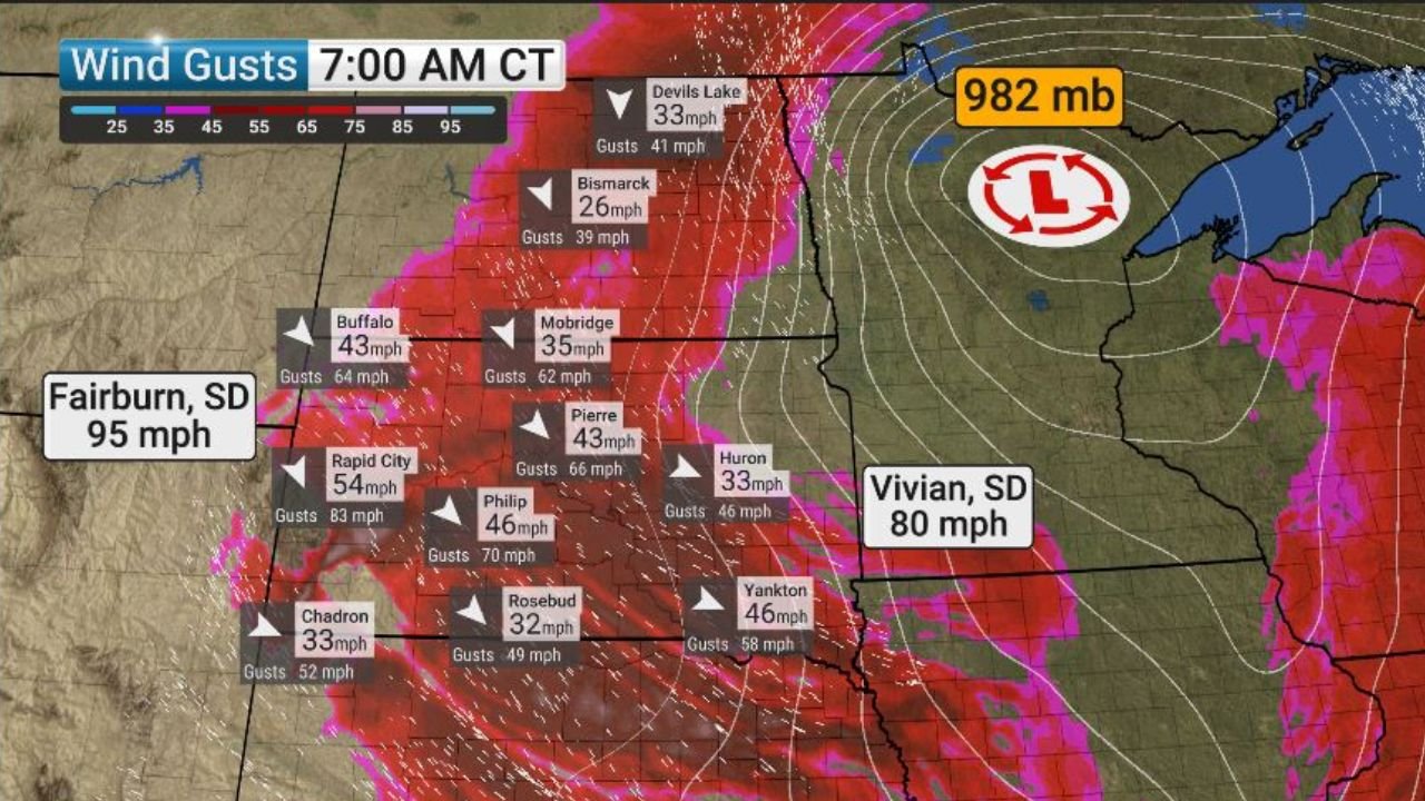
UNITED STATES — An intense 982-millibar cyclone centered over northern Minnesota is generating extreme, damaging wind gusts across the northern Plains, with the most severe impacts reported in western South Dakota and extending into North Dakota and Minnesota. Early-morning observations show wind gusts approaching hurricane force, creating dangerous conditions for travel, infrastructure, and outdoor safety.
Western South Dakota Bears the Brunt of the Strongest Winds
The most extreme winds have been recorded across western South Dakota, where gusts surged to near 100 mph in some locations. Fairburn, South Dakota, reported a peak gust of 95 mph, while surrounding areas experienced widespread gusts well above 70 mph.
“These are damaging, destructive winds capable of downing trees, power lines, and causing structural damage,” meteorologists warned.
Communities near Rapid City, Philip, Buffalo, and Rosebud have been impacted by powerful wind bursts, with conditions deteriorating rapidly during the morning hours.
North Dakota Sees Widespread High Winds From the Same System
As the cyclone rotates, North Dakota is also experiencing strong to severe wind gusts, particularly across central and western parts of the state. Observations show gusts exceeding 60 mph in areas such as Mobridge and Pierre, with sustained strong winds contributing to hazardous travel.
“The pressure gradient around this cyclone is exceptionally tight, allowing winds to accelerate rapidly across the region.”
Blowing dust and reduced visibility are possible in open and rural areas, adding to the danger for drivers.
Northern Minnesota Anchors the Dangerous Cyclone
The core of the storm — a deep 982-mb low pressure center — is positioned over northern Minnesota, driving the extreme wind field across surrounding states. While Minnesota’s strongest winds are occurring farther west of the low’s center, gusty conditions remain likely across northern portions of the state.
The cyclone’s strength places it among the more powerful non-tropical systems, especially for producing damaging wind impacts far from its center.
Why This Wind Event Is So Dangerous
Meteorologists point to several factors intensifying this event:
- Exceptionally low surface pressure (982 mb)
- Tight pressure gradient, accelerating winds
- Cold-season dynamics, allowing stronger momentum transfer to the surface
“Winds of this magnitude can cause damage similar to a weak hurricane, even without thunderstorms.”
Safety Warnings and What Residents Should Do
Emergency officials urge residents across South Dakota, North Dakota, and Minnesota to take immediate precautions:
- Avoid unnecessary travel, especially in high-profile vehicles
- Secure loose outdoor items
- Stay clear of trees and power lines
- Prepare for possible power outages
Conditions may gradually improve as the cyclone weakens and shifts east, but dangerous winds are expected to persist for several hours.
WaldronNews.com will continue to monitor this high-impact Plains wind event and provide updates as conditions evolve.