
Texas, Oklahoma, Arkansas, Louisiana, and Mississippi Face the Strongest Late-December Warmth as Winter Cold Fails to Arrive
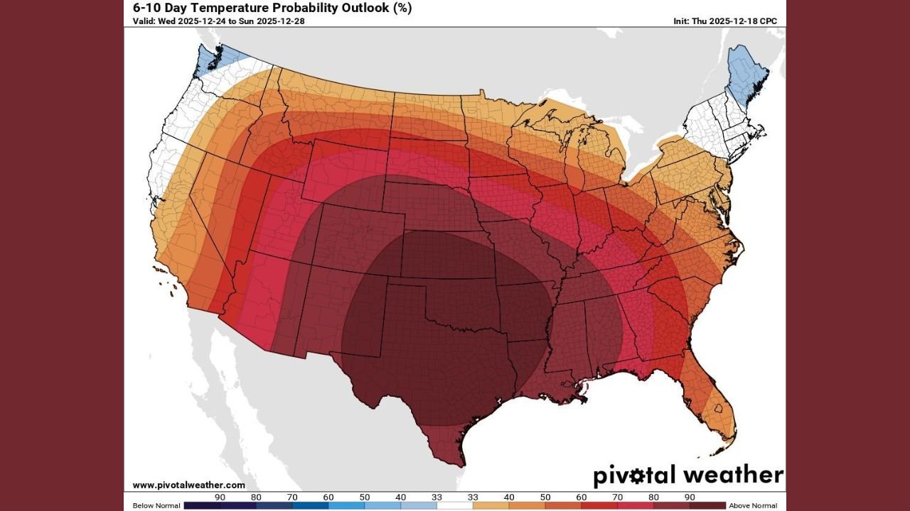
UNITED STATES — Newly released 6–10 day temperature probability outlook data shows that astronomical winter will begin with little to no traditional winter cold across large portions of the central and southern United States, with the most intense and widespread warmth centered over the Southern Plains and Lower Mississippi Valley.
The outlook, valid from December 24 through December 28, highlights several states where the probability of above-normal temperatures is exceptionally high, signaling a delayed and muted start to winter.
Primary Impact Zone: Southern Plains and Lower Mississippi Valley
The most impacted region, based on the darkest and most concentrated warm shading on the maps, includes:
- Texas
- Oklahoma
- Arkansas
- Louisiana
- Mississippi
Across this zone, temperature probabilities show a 70% to greater than 90% likelihood of above-normal temperatures, indicating strong confidence that winter cold will largely remain absent during this period. This area represents the core of the warm anomaly shown in the data.
Secondary Impact Zone: Southeast and Mid-South
Surrounding the core warm region, above-normal temperatures are also strongly favored across:
- Alabama
- Georgia
- Tennessee
- Missouri
- Illinois
- Kentucky
While probabilities in these states are slightly lower than in the Southern Plains, the data still clearly supports a warm-leaning pattern, particularly for overnight lows that typically define winter conditions in late December.
Limited Winter Presence in the Northern U.S.
The data shows very limited areas where colder-than-normal temperatures are favored, confined mainly to:
- Parts of northern New England
- Small sections of the Pacific Northwest
Even in these areas, the cold signal is narrow in coverage and does not suggest widespread or persistent winter conditions.
Why Winter Will Feel Absent for Many Areas
Based on the probability outlook:
- Cold air intrusions are not expected to reach deep into the southern or central U.S.
- Snow potential will be minimal outside of far northern regions
- Heating demand may remain lower than seasonal averages
- Seasonal patterns may feel more like early spring than late December
Meteorologists emphasize that this does not eliminate winter entirely, but it does point to a delayed and subdued start, particularly for the states most impacted by the warm anomaly.
What Comes Next
Forecast confidence is strong for the 6–10 day window shown, but longer-range trends will determine whether colder air eventually develops as January approaches. For now, astronomical winter will begin with widespread warmth dominating much of the nation.
WaldronNews.com will continue monitoring temperature trends and seasonal shifts as new forecast data becomes available.