
Colorado Front Range Slammed by Extreme Windstorm as Gusts Top 110 MPH and Humidity Drops Into Single Digits
BOULDER COUNTY, COLORADO — A powerful and dangerous windstorm tore across Colorado’s Front Range on Thursday, producing hurricane-force wind gusts exceeding 110 miles per hour, extremely low humidity, and widespread hazardous conditions from Boulder County through Jefferson, Larimer, and surrounding areas, according to confirmed observations and local weather reports.
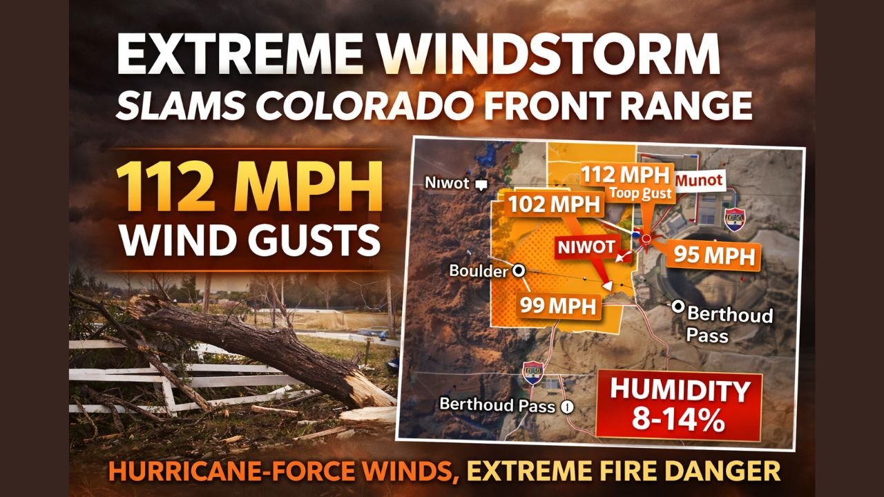
Meteorologists reported a peak wind gust of 112 mph at the NCAR Mesa Laboratory, one of the strongest non-tornadic wind measurements ever recorded along the Front Range. Additional confirmed gusts included 102 mph near Niwot, with dozens of locations reporting winds over 80 mph throughout the day.
At the same time, relative humidity plunged to just 8–14 percent, creating a highly volatile environment with elevated fire danger and the potential for rapid wildfire spread had any ignition occurred.
Hurricane-Force Wind Gusts Recorded Across Multiple Counties
Data compiled from automated weather stations and spotter reports shows the wind event was both intense and widespread.
Notable peak gusts included:
- 112 mph — NCAR Mesa Lab (Boulder County)
- 102 mph — Near Niwot
- 99 mph — Near Marshall and Crisman areas
- 95–98 mph — Berthoud Pass, Carter Lake, and surrounding high terrain
- 80–90+ mph — Numerous locations across Boulder, Jefferson, Larimer, Clear Creek, Douglas, and Weld counties
Even lower-elevation communities experienced damaging winds, with 50–70 mph gusts common in towns and along major roadways, leading to difficult travel conditions for high-profile vehicles.
Extremely Low Humidity Added to Fire Danger
While the winds alone posed a serious threat, conditions were made more dangerous by exceptionally dry air. Observations showed humidity values between 8 and 14 percent during the peak of the windstorm.
This combination of strong downslope winds, dry fuels, and low humidity is a classic setup for explosive wildfire growth. Fire officials emphasized that any spark could have spread rapidly, especially along foothill corridors and open grasslands.
Fortunately, no large fires were reported during the height of the event.
Why the Winds Were So Extreme
The windstorm was driven by a strong pressure gradient and downslope flow off the Rockies, allowing powerful winds aloft to mix down to the surface. As air descended the eastern slopes of the mountains, it accelerated dramatically, producing localized but extreme gusts, particularly near ridgelines and foothill gaps.
This type of setup is well known along the Front Range but rarely reaches the intensity observed on Thursday.
Ongoing Impacts and Safety Concerns
Even after peak winds subsided, officials warned of lingering hazards, including:
- Downed tree limbs and unsecured debris
- Isolated power disruptions
- Continued elevated fire risk in dry areas
- Dangerous travel for trucks and trailers
Residents were urged to secure loose objects, avoid outdoor burning, and remain alert for changing conditions, especially during future wind events.
What Happens Next
Winds are expected to gradually weaken, but forecasters note that Colorado’s Front Range remains vulnerable to similar high-wind events during winter, particularly when strong Pacific systems interact with downslope flow.
Emergency managers emphasized that this event serves as a reminder that Colorado windstorms can rival the strength of hurricanes, even without thunderstorms or tornadoes.
Residents across the Front Range are encouraged to stay weather-aware, especially during periods of high winds and dry conditions.
For continued updates on regional weather impacts, stay with WaldronNews.com.