
Extreme Fire Weather Emergency Unfolds in Colorado and Wyoming Under PDS Red Flag Warning and Violent Winds
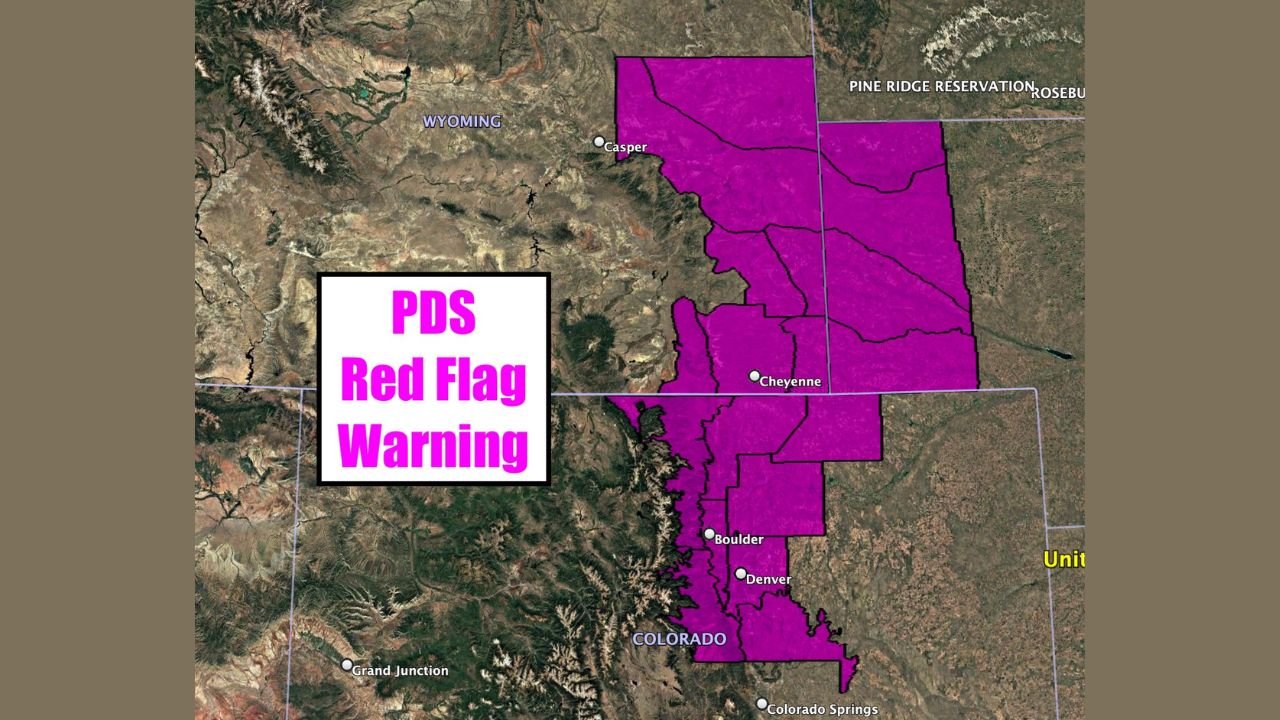
CHEYENNE, WYOMING — Extremely critical fire weather conditions are expected Friday along the eastern foothills of the Rocky Mountains, stretching from southeast Wyoming into northern Colorado, prompting the National Weather Service to issue a Particularly Dangerous Situation (PDS) Red Flag Warning for the region.
According to forecast data, the most severe conditions are expected near and east of the Front Range, impacting Cheyenne, Fort Collins, Boulder, Denver, and surrounding foothill communities. Meteorologists warn that any fire that starts could spread rapidly and uncontrollably due to the dangerous combination of extreme winds, very low humidity, and dry fuels.
Why Fire Conditions Are Considered “Extremely Critical”
Forecast models show sustained winds of 15 to 25 mph, with surface winds accelerating dramatically due to terrain effects. Gusts could reach 45 to 55 mph, with mountain wave–enhanced gusts potentially exceeding 85 to 105 mph in exposed foothill and ridge locations.
At the same time, relative humidity is expected to drop to near 10 percent, creating an environment highly favorable for rapid and erratic fire behavior. Fire weather experts note that even a small ignition source—such as sparks from equipment, downed power lines, or discarded cigarettes—could trigger a fast-moving wildfire.
Areas Most at Risk Across Colorado and Wyoming
The highest-risk corridor extends along the Colorado Front Range and adjacent southeastern Wyoming, including:
- Cheyenne, Wyoming
- Fort Collins, Colorado
- Boulder and Denver metro foothills
- Northern Colorado plains east of the foothills
- Foothill zones where downslope winds intensify
Maps provided by the Storm Prediction Center highlight a narrow but intense zone of “Extremely Critical” fire weather, surrounded by broader Critical and Elevated fire risk areas across eastern Colorado.
What a PDS Red Flag Warning Means
A Particularly Dangerous Situation Red Flag Warning is issued only in rare cases when meteorologists expect exceptional fire behavior. These warnings indicate conditions that can lead to:
- Rapid wildfire growth
- Long-range ember spotting
- Fires that are difficult or impossible to control
- Immediate threats to life and property
Officials urge residents to avoid all outdoor burning, delay activities that could produce sparks, and remain alert for changing conditions throughout the day.
Safety Guidance for Residents
Fire officials recommend the following precautions:
- Avoid using outdoor equipment that could spark
- Secure loose objects due to extreme winds
- Prepare evacuation plans in high-risk areas
- Report smoke or fire immediately to authorities
- Follow all local fire restrictions without exception
Emergency managers stress that today is not a day for complacency, especially in foothill and grassland areas where fuels are dry and winds are strongest.
Outlook Moving Forward
While the PDS Red Flag Warning is valid through Friday, officials note that conditions may evolve rapidly as wind patterns shift. Residents across northern Colorado and southeastern Wyoming are urged to stay informed through official weather updates and local emergency alerts.
WaldronNews.com will continue monitoring this developing fire weather threat and provide updates as conditions change.