
Washington, Oregon, and California Face Potential Christmas Windstorm as Forecast Models Show Extreme Uncertainty
WESTERN UNITED STATES — Forecast confidence remains unusually low heading into Christmas week as weather models diverge sharply on the strength of a potentially significant West Coast storm that could impact Washington, Oregon, and northern California, according to the latest guidance analyzed Sunday.
Some high-resolution forecast models are depicting a powerful windstorm capable of producing damaging to potentially historic wind gusts, while others show a far less severe outcome. Meteorologists say the next 48–72 hours will be critical in determining which scenario becomes more likely.
Conflicting Models Show Dramatically Different Outcomes
Current model disagreement is centered on how deep and organized the storm becomes as it rides northward along the Pacific Coast around Christmas Eve.
One scenario, shown by the NAM (North American Mesoscale) model, depicts a powerful wind event with widespread 65–85 mph wind gusts across much of western Washington, western Oregon, and parts of northern California. If this scenario were to verify, it would represent one of the strongest windstorms the region has experienced in decades, with the potential for widespread power outages, downed trees, and infrastructure damage.
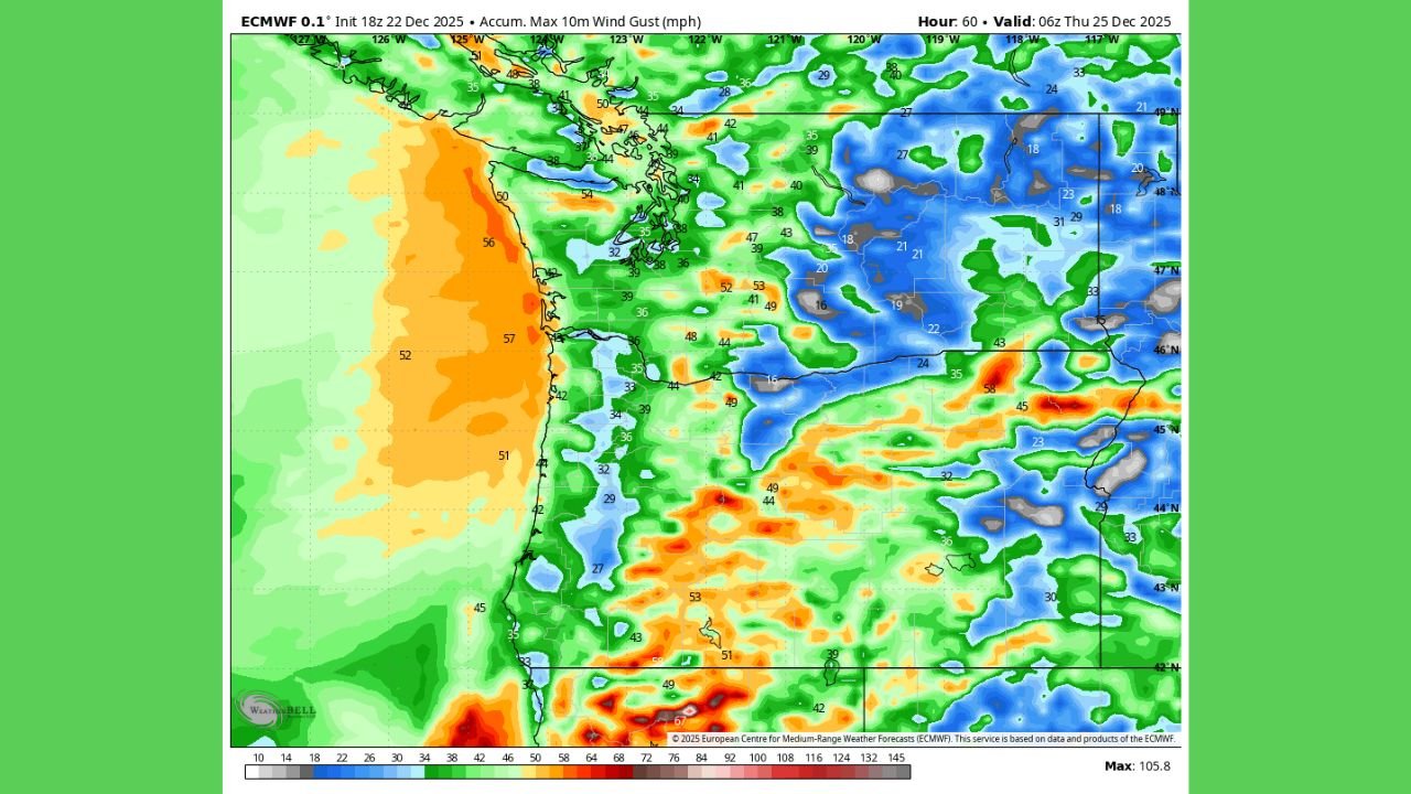
In contrast, the ECMWF (European) model paints a much weaker picture, showing breezy but manageable winds in the 30–40 mph range, particularly along coastal areas, which would result in far more limited impacts.
Areas at Highest Risk If Stronger Scenario Develops
If the stronger solution gains support, the most vulnerable areas would include:
- Coastal and lowland western Washington, including the Puget Sound region
- Western Oregon, from the Coast Range through the Willamette Valley
- Northern California coastal counties, especially exposed headlands and higher terrain
Mountain passes and forested regions would be especially susceptible to falling trees and blocked roadways should high wind gusts materialize.
Why Forecast Confidence Is Low
Meteorologists note that the storm’s strength depends heavily on small-scale atmospheric details that models are struggling to resolve at this range. Slight changes in the storm’s track, jet stream alignment, or pressure gradient could dramatically alter wind speeds at the surface.
This level of disagreement so close to the event is uncommon, underscoring the need for caution and close monitoring rather than alarm at this stage.
What Residents Should Do Now
While it is too early to determine the exact impact level, residents across Washington, Oregon, and northern California are advised to:
- Monitor updated forecasts through the week
- Be prepared for possible power outages
- Secure loose outdoor items ahead of Christmas Eve
- Avoid travel in forested or coastal areas if high winds are forecast
Officials stress that no warnings or watches are in effect yet, but those could change quickly if confidence increases.
More Clarity Expected Soon
Forecasters expect model agreement to improve over the next couple of days as the storm moves closer to the coast and becomes better sampled by weather observations. Until then, experts emphasize preparedness without panic.
Residents are encouraged to check official updates frequently, especially if holiday travel or outdoor plans are scheduled late this week.
Stay informed with the latest developing weather updates and regional impact reports by visiting WaldronNews.com — and let us know how conditions are unfolding in your area.