
New York, Pennsylvania, New Jersey, Maryland, and New England Face December 23–24 Snowstorm With Ice Risk South and Heavy Snow North
UNITED STATES — A developing winter storm is expected to bring a mix of snow, sleet, and freezing rain across New York, Pennsylvania, New Jersey, Maryland, and the New England states from late Monday night into Tuesday and early Wednesday, with the most significant impacts expected between December 23 and December 24, according to the latest forecast data and regional model guidance.
Meteorologists describe this system as a classic overrunning winter storm, meaning warmer air will move over a shallow layer of cold air at the surface. That setup increases the risk of mixed precipitation in some areas while allowing heavier snow to accumulate farther north and at higher elevations.
Storm Timing by Region
Snow and mixed precipitation are expected to arrive in stages as the system moves northeast.
In New York, Pennsylvania, New Jersey, and Maryland, precipitation is forecast to begin after midnight Monday night and continue through Tuesday morning. Southern New England, including Connecticut, Rhode Island, and eastern Massachusetts, should see precipitation develop between noon and 2 p.m. Tuesday, while northern New England—including parts of Vermont, New Hampshire, and Maine—may not see snow begin until late Tuesday afternoon or early evening.
Once precipitation begins, most locations will see around 12 hours of steady precipitation before tapering off.
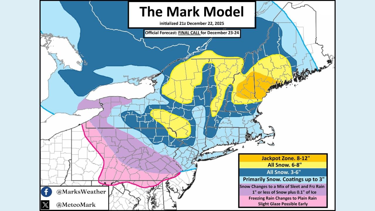
Snow, Ice, and Mixed Precipitation Zones
Forecast maps show a clear north-to-south gradient in precipitation type.
Across central and northern New England, colder air will remain locked in place, allowing snow to fall for a longer duration. This region is expected to see the highest snowfall totals, with a potential jackpot zone developing where snow begins earliest and ends last. Some areas could see 6 to 8 inches of snow, with localized higher amounts possible.
Farther south, including parts of southern Pennsylvania and northern Maryland, warmer air aloft may intrude. In these areas, snow could change to sleet or freezing rain, leading to light ice accretion. Forecasters note that even a thin glaze of ice can cause hazardous travel, especially during the early morning commute.
In valleys and lower elevations, totals may be lower, while higher elevations across the Appalachians and interior New England are favored to see the upper end of snowfall ranges.
Why Forecast Confidence Is Moderate
Forecasters emphasize that while confidence is increasing, small temperature differences near the surface could still shift snow totals and precipitation types. If cold air near the ground is stronger than models currently suggest, snow could extend farther south. If warmer air wins out, ice and sleet totals could increase instead.
Recent trends have favored colder solutions, which is why snowfall zones have edged slightly southward in the latest projections.
Travel and Safety Impacts
Road conditions are expected to deteriorate quickly once precipitation begins, particularly overnight and during Tuesday morning. Icy conditions are possible in southern portions of the storm, while heavy snow could reduce visibility and slow travel across New England.
Officials urge drivers to monitor local forecasts, allow extra travel time, and prepare for rapidly changing conditions.
What to Watch Next
Forecasters will continue refining snowfall and ice maps as newer data arrives. The highest confidence remains on significant winter weather across New England, with mixed precipitation risks in Pennsylvania and Maryland.
Residents across New York, Pennsylvania, New Jersey, Maryland, and New England should stay weather-aware as the December 23–24 winter storm approaches.
For continued updates and local impact coverage, visit WaldronNews.com.