
Southern California Faces Life-Threatening Flood and Mudslide Risk as Extreme Rain Targets Southern Counties This Week
SOUTHERN CALIFORNIA — A dangerous and potentially life-threatening flash flooding situation is developing across parts of California, as forecasters warn that an intense, slow-moving storm system could bring historic rainfall totals to portions of the state beginning Tuesday night and continuing through Thursday morning.
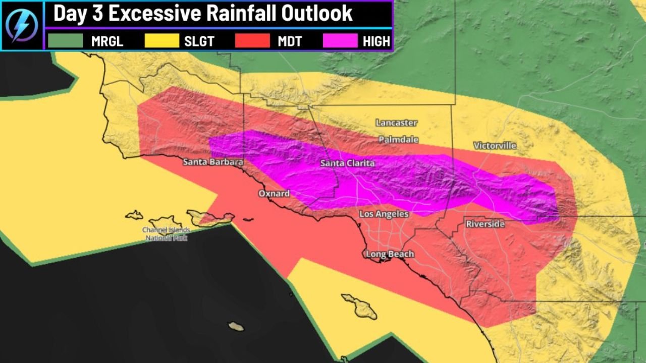
Highest Flood Risk Now Issued for Southern California
According to the latest Excessive Rainfall Outlook, the threat level has escalated to the highest category (HIGH risk) for flash flooding across a large portion of Southern California. The most dangerous conditions are expected in:
- Santa Barbara County
- Ventura County
- Los Angeles County
- San Bernardino County
- Parts of Riverside County
The most extreme impacts are expected along the Transverse Ranges, where mountainous terrain dramatically increases runoff and debris flow potential.
Rainfall Totals Could Reach 10–20 Inches in Some Areas
Forecast models show widespread rainfall totals of 5 to 10 inches, with localized amounts between 10 and 20 inches possible in foothill and mountain communities. These totals are especially concerning for:
- Recent burn scar areas
- Steep canyon terrain
- Urban zones with poor drainage
Meteorologists warn that rainfall rates may become intense enough to overwhelm creeks, storm drains, and roadways within minutes.
Mudslides and Debris Flows a Major Concern
Emergency officials stress that this event carries a high risk for mudslides and debris flows, particularly where vegetation has been weakened by recent wildfires. Even moderate rain in these locations can rapidly trigger:
- Hillside collapses
- Rockslides onto roadways
- Sudden debris surges through neighborhoods
Residents in or near burn scar zones are urged to prepare for possible evacuations and remain alert for rapidly changing conditions.
Timing: When the Worst Conditions Are Expected
- Tuesday evening: Rain intensifies across coastal and foothill areas
- Overnight Tuesday into Wednesday: Peak rainfall rates develop
- Wednesday afternoon to early Thursday: Ongoing heavy rain with flash flood risk
- Thursday morning: Gradual improvement expected from west to east
Officials warn that nighttime flooding poses an added danger due to reduced visibility and limited reaction time.
Travel and Safety Impacts
Drivers are urged to avoid travel during heavy rainfall, especially overnight. Flooded roadways, sudden washouts, and falling debris could make conditions extremely hazardous. Emergency officials emphasize:
- Never drive through flooded roads
- Avoid canyon roads and low-lying areas
- Have multiple evacuation routes planned
What Residents Should Do Now
Authorities recommend immediate preparation:
- Monitor local emergency alerts
- Prepare an evacuation plan if you live in a high-risk area
- Clear storm drains near your home if safe to do so
- Keep emergency supplies ready, including flashlights and batteries
A High-Impact Event Still Evolving
Forecasters note that while exact rainfall totals may shift, confidence is high that Southern California will face a significant and dangerous weather event. Even small changes in storm positioning could dramatically affect which communities see the worst impacts.
Residents across Southern California are urged to take this threat seriously and remain weather-aware as conditions rapidly evolve.
Stay with WaldronNews.com for continuing updates as new forecasts, warnings, and emergency information become available.