
Massachusetts Coastal Snow Band Possible as Norlun-Type Feature Targets East and Southeast Areas
MASSACHUSETTS — Parts of eastern and southeastern Massachusetts could see a narrow but impactful band of snowfall on Wednesday as a norlun-type coastal feature develops offshore and pulls colder air into the region, according to the latest high-resolution model guidance.
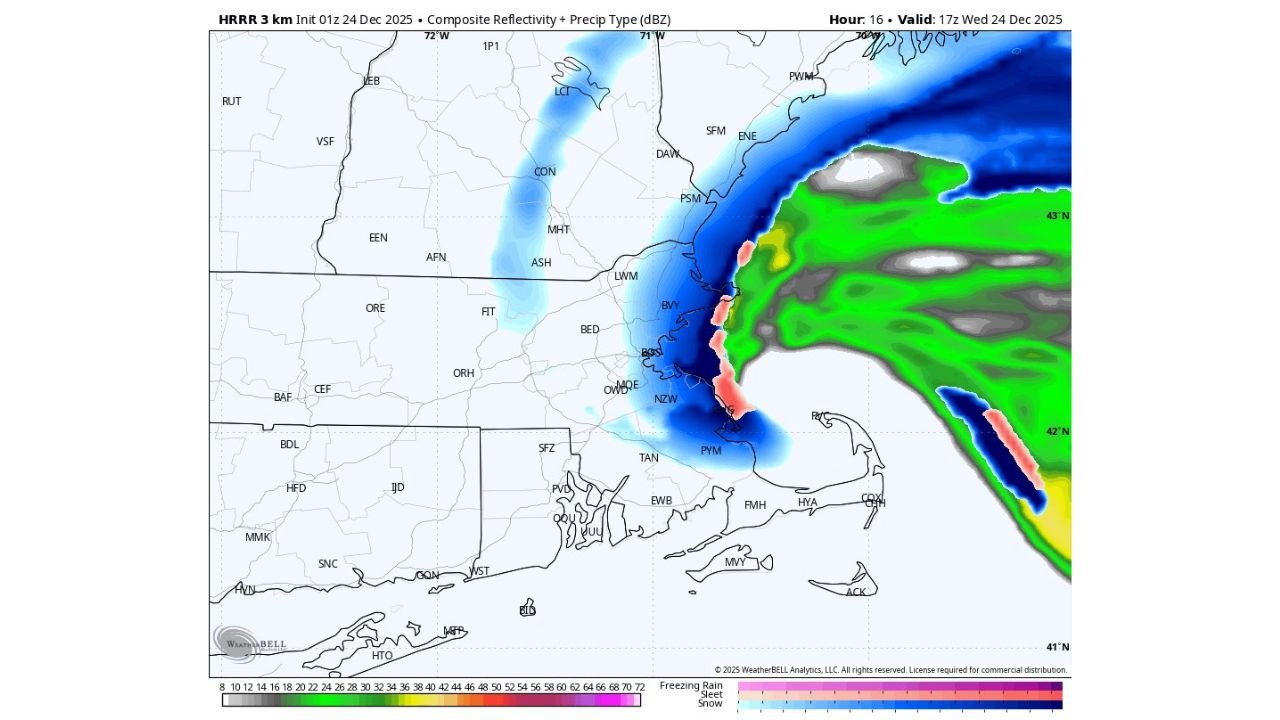
Forecast data shows a tight, coast-hugging snow band setting up from the North Shore through Boston and down toward Plymouth County and Cape Cod, with the greatest potential for measurable accumulation closest to the shoreline. While this is not expected to be a widespread snowstorm, conditions may change rapidly in affected areas.
Why This Setup Matters for Eastern Massachusetts
A norlun-type trough forms when two low-level wind flows converge along the coast, forcing air upward and enhancing precipitation in a very focused zone. In this case, colder air filtering in during the day Wednesday increases the chance that precipitation falls as snow rather than rain, especially during the afternoon and evening hours.
Model output indicates that even brief periods of moderate snow could be enough to coat roads, sidewalks, and untreated surfaces, particularly in coastal communities where temperatures drop just enough for accumulation.
Areas Most Likely to See Snow
Based on current guidance, the highest probability zone includes:
- Boston metro eastward
- Coastal Essex County
- Coastal Norfolk and Plymouth counties
- Outer Cape Cod and immediate shoreline areas
Snow amounts appear highly localized, but coastal sections could see a light accumulation, with some models showing up to a few inches where the band persists the longest. Just a few miles inland, totals may drop sharply or remain minimal.
Timing and Impacts
The snow band is most likely to develop Wednesday afternoon into the evening, coinciding with colder air arriving from the north. Because of the narrow nature of the feature:
- Some locations may see steady snow for an hour or two
- Nearby towns could see little to no snowfall
- Roads could become slick quickly, even with modest totals
Travel impacts would be localized but potentially sudden, especially during the evening commute along coastal routes.
Forecast Confidence and Uncertainty
Confidence is moderate that a snow band forms, but lower on exactly where it sets up. Norlun features are notoriously difficult to pinpoint more than a few hours in advance, and small shifts in wind direction could move the heaviest snow east over the ocean or slightly farther inland.
Residents in eastern Massachusetts are advised to monitor short-term updates, especially if traveling late Wednesday.
Should This Article Be Published?
Yes — this article is appropriate to publish.
This setup is distinct from broader regional winter storm coverage and focuses on a specific, high-interest local impact area (eastern and southeastern Massachusetts). Because it highlights a localized coastal snow threat tied to a unique meteorological feature, it adds value rather than duplicating previous coverage.
However, avoid publishing multiple near-identical Massachusetts snow articles within the same 12–18 hour window unless:
- New model runs significantly increase totals
- Official advisories or warnings are issued
- The snow band location becomes more certain
Publishing this once, with updates folded into the same article if needed, is the safest approach to avoid platform suppression.
Stay with WaldronNews.com for the latest localized winter weather updates as this forecast evolves.