
Winter Weather Advisory Issued for Massachusetts, Connecticut, and Rhode Island as Freezing Rain May Create Slick, Icy Conditions Sunday Night Into Monday Morning
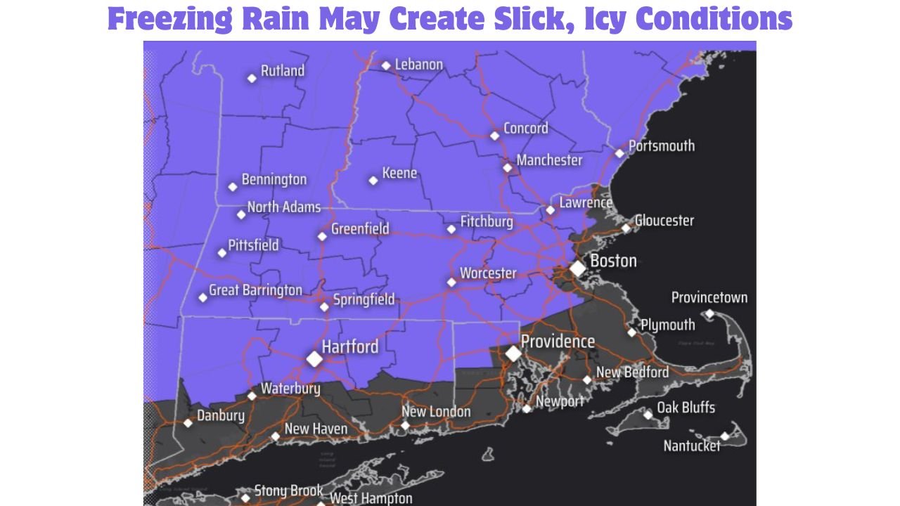
MASSACHUSETTS — A Winter Weather Advisory has been issued for western and central Massachusetts, northern Connecticut, and northern Rhode Island, as a period of freezing rain Sunday evening into early Monday morning is expected to create slick and hazardous travel conditions, according to the National Weather Service.
Forecasters warn that a light glaze to as much as a quarter-inch of ice is possible in interior areas, particularly on untreated roads, sidewalks, and elevated surfaces, before temperatures rise enough for precipitation to change over to plain rain by Monday morning.
Advisory Timing and Coverage
The Winter Weather Advisory is in effect:
- Start: Sunday at 7:00 PM
- End: Monday at 6:00 AM
The advisory covers much of interior southern New England, extending from western and central Massachusetts through northern Connecticut and northern Rhode Island, generally north and west of Interstate 95.
Freezing Rain and Ice Accumulation Expected
The primary hazard with this system will be freezing rain, which occurs when rain freezes on contact with cold surfaces.
Forecast details include:
- Light glaze to up to 0.25 inches of ice in interior areas
- Highest confidence for icing north of the Massachusetts Turnpike
- Icing most likely on bridges, overpasses, untreated roads, and sidewalks
Even small ice amounts can significantly increase the risk of vehicle accidents and pedestrian falls.
Travel Impacts and Safety Concerns
Residents should be prepared for:
- Icy roads and sidewalks, especially late Sunday night
- Hazardous driving conditions during the Monday morning commute
- Slower travel times and possible minor accidents
- Difficult walking conditions in residential and urban areas
Because freezing rain often occurs quietly overnight, conditions may appear worse than expected early Monday.
Potential for Power Issues
While widespread outages are not currently expected, forecasters note that:
- Ice buildup on trees and power lines could lead to isolated outages
- Recent snowfall may make trees more vulnerable to ice loading
- Interior higher elevations face a slightly greater risk
What Residents Should Do
People in advisory areas are urged to:
- Avoid unnecessary travel late Sunday night if possible
- Use caution on bridges and elevated roadways
- Allow extra time for the Monday morning commute
- Wear footwear with good traction when walking outdoors
- Monitor local updates in case advisories are expanded or upgraded
Bottom Line
A Winter Weather Advisory is in effect for parts of Massachusetts, Connecticut, and Rhode Island due to freezing rain and ice accumulation Sunday evening through early Monday morning. While snowfall amounts will be minimal, even light icing can create dangerous travel conditions, particularly overnight and during the early commute.
Residents across interior southern New England should remain alert and take precautions as conditions deteriorate.
Stay with WaldronNews.com for continued weather updates and any changes to advisories or warnings as this system moves through the region.