
Southern and Central Michigan to See 1–1.5 Inches of Rain Sunday, With Localized Flooding Risk Before Overnight Snow Transition
MICHIGAN — A widespread rain system is expected to move across lower Michigan on Sunday, December 28, bringing moderate rainfall, pockets of heavier downpours, and slick travel conditions before exiting early Monday morning and giving way to lake-effect snow in northern areas.
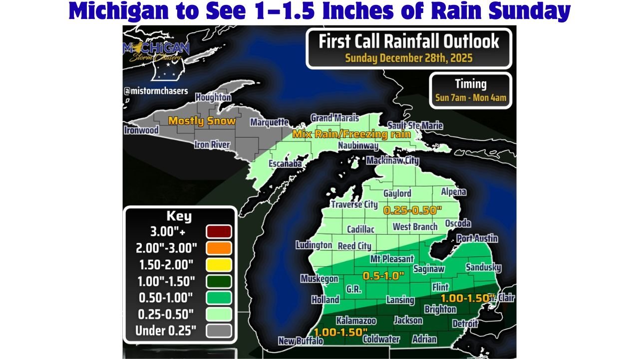
Forecast data shows the heaviest rainfall will focus on southern Michigan, while totals gradually taper off farther north across the state.
Heaviest Rain Expected Across Southern Michigan
The strongest swath of rainfall is forecast to develop across far southern Michigan, where totals of 1.00 to 1.50 inches are expected by late Sunday night.
- Far southern Michigan: 1.00″ to 1.50″
- Central Michigan: 0.50″ to 1.00″
- Northern lower Michigan: 0.25″ to 0.50″
Rainfall amounts decrease steadily moving north, with the lightest totals expected near the Straits and northern lower Michigan.
Thunderstorms Could Push Local Totals Higher
Along with steady rain, scattered thunderstorms are possible Sunday, especially across central and southern lower Michigan. While severe weather is not expected, any stronger storms could briefly increase rainfall rates, leading to locally higher totals in some areas.
Forecasters note that parts of southern Michigan could see amounts exceed 1.5 inches if heavier downpours persist over the same locations.
Flooding Threat Remains Limited but Localized Issues Possible
Despite the rainfall, widespread or major flooding is not anticipated. However, localized impacts are possible, particularly in low-lying or poor-drainage areas.
Potential concerns include:
- Ponding of water on roads
- Runoff in low-lying neighborhoods
- Minor flooding near clogged drains and ditches
Drivers are advised to use caution, especially during heavier rain Sunday afternoon and evening.
Rain Timeline: Sunday Morning Through Early Monday
Rain is expected to begin early Sunday morning, becoming more widespread through the day and evening hours.
- Rain begins: Early Sunday morning
- Heaviest rain: Sunday afternoon into evening
- Rain ends: Between midnight and 4 a.m. Monday
As colder air arrives overnight, precipitation will gradually taper off from south to north.
Transition to Snow Late Sunday Night
Behind the departing rain system, colder air will move into Michigan, allowing precipitation to change over to lake-effect snow, especially across northern lower Michigan and areas downwind of the Great Lakes.
While snowfall amounts were not specified in the rainfall outlook, travel conditions may deteriorate quickly overnight as temperatures fall and winds increase.
What Residents Should Prepare For
- Wet roads and reduced visibility Sunday
- Localized ponding in low-lying areas
- Changing conditions overnight as rain turns to snow
- Slower travel during evening and overnight hours
Are you seeing heavy rain, ponding, or changing conditions where you live? Share your local updates and stay connected with WaldronNews.com for continued weather coverage and Michigan-focused alerts.