
Severe Thunderstorm Warning Continues for Augusta and Brooksville, Kentucky, and Higginsport, Ohio, With 60 MPH Winds and Tornado Risk Until 11:30 PM
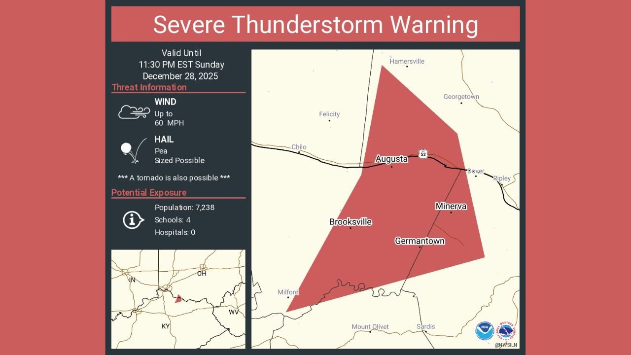
KENTUCKY — A Severe Thunderstorm Warning remains in effect late Sunday night for Augusta KY, Brooksville KY, and Higginsport OH, with dangerous storms expected to continue until 11:30 PM EST, according to National Weather Service warning data shown in the latest alert maps.
Forecasters warn that this storm system is capable of producing damaging wind gusts up to 60 mph, pea-sized hail, and conditions favorable for a possible tornado, creating a serious risk for residents across northern Kentucky and southern Ohio near the Ohio River.
Storm Threat Details
The warning highlights multiple hazards associated with the storm as it moves through the region:
- Damaging Winds: Gusts up to 60 mph capable of knocking down trees and power lines
- Hail: Pea-sized hail possible in stronger storm cores
- Tornado Risk: Meteorologists note that a tornado cannot be ruled out within this storm
- Power Outages: Strong winds may cause localized power disruptions
The warned area includes populated communities such as Augusta, Brooksville, Minerva, and Germantown, placing thousands of residents directly in the path of the storm.
Communities and Population at Risk
Emergency exposure data associated with the warning indicates:
- Estimated Population Impacted: 7,238 people
- Schools in the Warning Area: 4
- Hospitals: None directly within the warned polygon
Residents in low-lying or tree-dense neighborhoods may face an elevated risk of wind damage and falling debris.
What Residents Should Do Right Now
Safety officials urge people in the warned areas to take immediate precautions:
- Move indoors immediately and stay away from windows
- Secure loose outdoor items that could become airborne
- Avoid travel until the warning expires
- Monitor local weather alerts for updates or escalation
If a tornado warning is issued, residents should move to a basement or interior room on the lowest floor of a sturdy building.
Storm Timing and Outlook
The Severe Thunderstorm Warning remains active through 11:30 PM EST Sunday night. Conditions may improve afterward, but additional warnings could be issued if storms intensify or redevelop.
Officials stress that nighttime storms are especially dangerous due to reduced visibility and delayed reaction time, making it critical to stay alert until the threat fully passes.
What are conditions like in your area right now?
Have you experienced strong winds, hail, or power outages? Share your updates and stay connected with WaldronNews.com for continued severe weather coverage and real-time alerts.