
Nevada Weather Update: Gusty Winds and Cooler Temperatures Hit Las Vegas as Cold Front Moves Through Thursday
NEVADA — A noticeable shift in weather is underway across southern Nevada as a cold front pushes into the Las Vegas Valley on Thursday, bringing strong winds, cooler temperatures, and a slight chance of showers, according to the latest National Weather Service outlook.
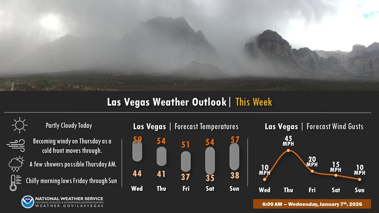
After a relatively calm and mild Wednesday, conditions are expected to deteriorate quickly as the front moves through, creating hazardous travel conditions and potential outdoor disruptions, especially during peak wind hours.
Strong Winds Expected as Cold Front Moves Through Las Vegas
Forecasters indicate that wind gusts could peak near 45 mph on Thursday, particularly during the afternoon and early evening hours. These winds will be driven by the cold front passing directly through southern Nevada, tightening pressure gradients across the region.
The strongest gusts are expected in:
- The Las Vegas Valley
- Nearby desert corridors
- Exposed roadways and mountain passes
Loose outdoor objects, high-profile vehicles, and temporary structures may be impacted during the strongest wind periods.
Temperatures Drop Behind the Front
Along with the wind, cooler air will settle into the region once the front passes. High temperatures will fall from the upper 50s on Wednesday to the low-to-mid 50s on Thursday, with overnight lows dropping into the upper 30s and low 40s by Friday morning.
This marks a return to more typical January weather after a brief stretch of warmer conditions earlier in the week.
Slight Chance of Showers, Limited Rainfall Expected
Forecasters are also tracking a small chance for light showers Thursday morning, though rainfall totals are expected to remain minimal. Any precipitation that does occur will be brief and spotty, with no widespread accumulation anticipated.
Confidence remains low regarding exact timing and coverage, but officials emphasize that rain is not expected to be impactful compared to the wind.
Chilly Mornings Continue Into the Weekend
Behind the front, cool and dry conditions will dominate the weekend forecast. Morning lows will remain chilly through Sunday, with highs generally staying in the mid-to-upper 50s.
While winds will gradually ease after Thursday, breezy conditions may linger into Friday before calming further over the weekend.
What Residents Should Know
- Secure loose outdoor items ahead of Thursday’s winds
- Use caution if driving high-profile vehicles
- Prepare for cooler mornings through the weekend
- Expect improving conditions after Friday
As always, stay aware of changing conditions and monitor local forecasts for updates as the cold front moves through southern Nevada.
For more regional weather updates and developing forecasts, keep following WaldronNews.