
Two Storm Systems Target Gulf Coast, Mississippi Valley, Tennessee Valley, and Ohio Valley With Severe Storms, Flooding Rain, and Heavy Snow
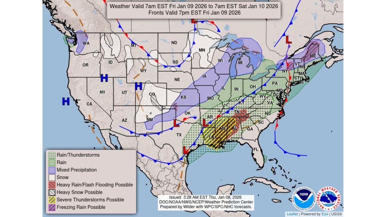
UNITED STATES — A complex and potentially dangerous weather pattern is setting up across the central and eastern United States as two separate storm systems track eastward through the region from Friday into Saturday, bringing a wide range of hazards including severe thunderstorms, flash flooding, heavy rain, gusty winds, and areas of heavy snow.
Forecast guidance shows the greatest impacts stretching from the central Gulf Coast and Lower Mississippi Valley northward into the Tennessee and Ohio Valleys, before the system pushes toward the Mid-Atlantic and New England.
Severe Thunderstorm Threat From the Central Gulf Coast Into the Tennessee Valley
The first storm system is expected to tap into warm, moisture-rich air from the Gulf of Mexico, creating conditions favorable for severe thunderstorms on Friday, especially across:
- Louisiana
- Mississippi
- Alabama
- Southern and central Tennessee
- Parts of Arkansas and Georgia
Within this zone, damaging wind gusts, torrential downpours, and isolated severe storms are possible. Some storms may become strong enough to produce localized wind damage and brief power outages, particularly where storms repeatedly move over the same areas.
Heavy to Excessive Rain Raises Flooding Concerns
One of the most significant threats with this system is heavy to excessive rainfall, particularly from the Lower Mississippi River Valley into the Tennessee Valley.
Forecast maps highlight areas at risk for flash flooding, especially across:
- Central and southern Mississippi
- Western and northern Alabama
- Southern Tennessee
- Parts of eastern Arkansas
Repeated rounds of rain and thunderstorms could lead to rapid rises on creeks and streams, urban flooding, and water covering low-lying roads. Flooding risk will be highest in areas that receive multiple inches of rain in a short period of time.
Winter Weather and Heavy Snow on the Northern Side of the System
While the southern side of the storm brings severe weather, colder air wrapping into the northern and western portions of the system will support winter precipitation, including snow and mixed precipitation.
Snow and mixed precipitation are expected across portions of:
- Kansas
- Missouri
- Iowa
- Illinois
- Wisconsin
- Michigan
- Parts of the central Plains and Upper Midwest
Some locations could see periods of heavy snow, leading to hazardous travel conditions, reduced visibility, and slippery roads, especially during overnight and early morning hours.
Second Storm Pushes Impacts Toward the East Coast and New England
As the systems continue eastward, rain, gusty winds, and mixed precipitation are expected to spread into the Mid-Atlantic and New England by late Friday into Saturday.
Northern New England may encounter freezing rain or snow, while coastal areas are more likely to see cold rain and strong winds, depending on how quickly colder air moves in behind the system.
What Residents Should Prepare For
People across the impacted regions should be prepared for:
- Severe thunderstorms and damaging winds in the South
- Flash flooding and road closures in heavy rain areas
- Dangerous travel conditions in snow and mixed precipitation zones
- Rapidly changing weather conditions over short distances
Residents are urged to monitor local forecasts, have multiple ways to receive weather warnings, and avoid flooded roadways.
Active Pattern Continues Into the Weekend
This multi-hazard storm setup highlights an active and volatile January weather pattern across the central and eastern U.S. Additional systems may follow behind this one, keeping weather conditions unsettled into next week.
WaldronNews.com will continue tracking this evolving storm threat and provide updates as new warnings or advisories are issued. Stay alert and stay safe.