
Potential Major East Coast Storm Could Impact Florida, Georgia, the Carolinas, and the Mid-Atlantic as Powerful Pattern Sets Up Late Next Week
UNITED STATES — Long-range forecast data is signaling a high-impact weather pattern developing late next week, one that could evolve into a significant coastal storm affecting Florida, the Southeast, the Mid-Atlantic, and parts of the Northeast if current trends continue.
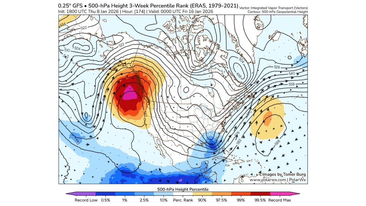
While details are still several days out, meteorologists are closely monitoring an unusual and potentially volatile atmospheric setup that includes record-strength high pressure in the far northeastern Pacific and a vigorous upper-level low developing near Florida—a combination that can favor strong East Coast storm development.
Record-Breaking Pacific Ridge Forcing Downstream Impacts
One of the key signals in the data is an exceptionally strong ridge of high pressure over the northeastern Pacific Ocean, ranking near record levels for this time of year based on historical climatology.
This ridge acts as a blocking mechanism, forcing the jet stream to buckle downstream across North America. As a result:
- Energy is displaced south and east across the U.S.
- A deep trough begins carving out over the eastern states
- Storm systems are steered toward the East Coast rather than out to sea
This type of pattern has historically been associated with large, slow-moving, and impactful coastal storms.
Unusually Strong Upper-Level Low Over Florida Raises Red Flags
At the same time, forecast models show a strong upper-level low developing near or over Florida, an unusual feature that could become the trigger point for significant storm development.
If this system phases correctly with northern energy, it could lead to:
- Heavy rain and strong to severe thunderstorms across Florida
- Potential severe weather extending into Georgia and the Carolinas
- A rapidly strengthening surface low tracking north along the East Coast
Florida appears particularly vulnerable to heavy rainfall and strong thunderstorms, given the deep moisture and instability available in this setup.
Mid-Atlantic and Northeast Could Face a Major Coastal Storm
Should the system organize and track offshore, states along the Mid-Atlantic and Northeast coastlines could see significant impacts, including:
- Virginia
- Maryland
- Delaware
- New Jersey
- New York
- Southern New England
Depending on the exact storm track and thermal profiles, impacts could range from heavy rain and damaging winds near the coast to snow or mixed precipitation inland, especially farther north.
Small shifts in timing or position could dramatically change outcomes, which is why forecasters stress that this system is still highly sensitive to minor changes.
Why Confidence Is Limited—but Concern Is Growing
At this range, it is too early to lock in exact impacts, but several high-confidence signals are present:
- Strong agreement on a high-amplitude jet stream pattern
- Consistent indications of a deepening eastern U.S. trough
- Increasing model support for coastal cyclogenesis potential
These ingredients do not guarantee a major storm—but they raise the ceiling for what is possible.
What to Watch Over the Coming Days
Residents across the eastern U.S. should monitor updates closely, especially in:
- Florida and the Southeast for heavy rain and severe storms
- The Mid-Atlantic for potential coastal impacts
- The Northeast for possible winter weather scenarios
As newer data comes in, confidence will increase rapidly one way or the other.
Bottom Line
A high-impact East Coast storm is not guaranteed, but the atmospheric pattern developing late next week strongly supports the potential for a major system affecting Florida, the Southeast, and the Mid-Atlantic. Even small changes could tip the balance toward a significant coastal storm event.
WaldronNews.com will continue to closely monitor this evolving setup and provide updates as confidence increases. Stay alert and stay prepared.