
East Coast Storm Threat Grows for January 15–17 as Florida, the Carolinas, Mid-Atlantic, and New England Face Possible High-Impact Coastal System
UNITED STATES — Confidence is slowly increasing that a significant East Coast storm threat could develop between January 15 and January 17, with forecast guidance continuing to highlight a dangerous and high-amplitude weather pattern capable of producing heavy rain, severe storms, strong winds, and potential snow from the Carolinas northward to New England.
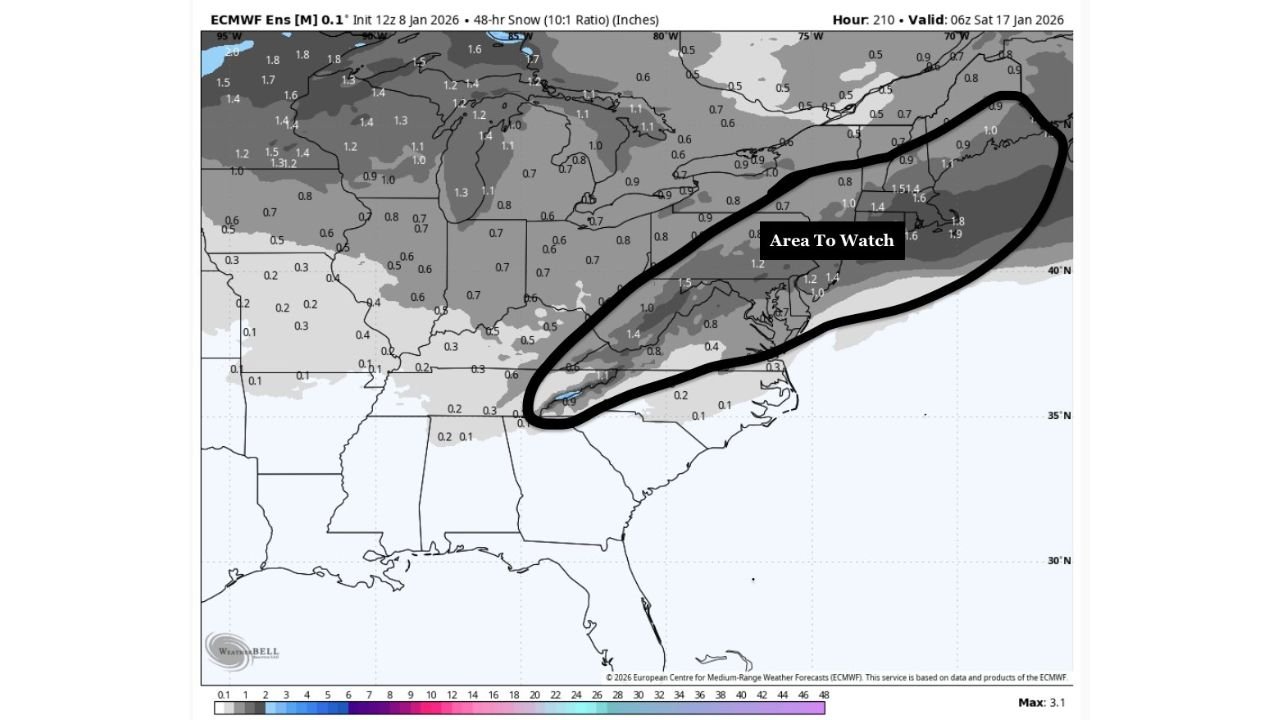
While exact impacts are still uncertain, the atmospheric signals supporting a major coastal storm remain firmly in place, prompting forecasters to flag a broad “area to watch” from the Southeast coast through the Mid-Atlantic and into the Northeast.
Storm Signal Now Appearing on Operational Models
Recent model runs show the storm signal beginning to consistently appear on operational guidance, a notable development compared to earlier projections. This shift suggests the setup is moving from a long-range idea toward a more realistic and trackable threat window.
The most likely timeframe for impacts currently centers on January 15–16, though adjustments of 12–24 hours remain possible.
Deep Trough Digging Into the Gulf Supports Coastal Development
All major guidance agrees on one key ingredient:
a strong upper-level trough digging southward into the Gulf of Mexico.
This is a critical requirement for a classic East Coast “Miller A” storm, where a surface low develops in the Gulf or Southeast and then rapidly intensifies while tracking north along the coastline.
This configuration favors:
- Strong moisture transport from the Gulf and Atlantic
- Rapid storm strengthening near the coast
- Widespread precipitation with sharp north-south gradients
Northern and Southern Stream Interaction Is the Wild Card
The biggest forecast uncertainty lies in the interaction between the southern stream trough and northern stream TPV (tropospheric polar vortex).
Model scenarios show two main outcomes:
- Favorable interaction → Storm tracks closer to the coast with widespread impacts
- Poor phasing → Storm remains offshore, limiting impacts inland
Current ensemble guidance suggests just enough separation to keep the storm threat alive, but small changes will have major consequences for who sees rain, snow, or wind.
Primary Threat Zone: Carolinas to Boston
At this stage, the highest-confidence impact corridor stretches from the Carolinas through the Mid-Atlantic and into southern New England, including:
- North Carolina
- Virginia
- Maryland
- Delaware
- New Jersey
- New York
- Massachusetts
- Southern New England
Depending on storm track and thermal profiles:
- Coastal areas may see heavy rain, strong winds, and coastal impacts
- Inland and higher-elevation areas could see snow or mixed precipitation
- A sharp rain-snow line is possible, especially across the Mid-Atlantic
Florida and Southeast Also Face Severe Weather Risk
Ahead of the potential coastal storm, Florida and parts of the Southeast may experience heavy rain and strong to severe thunderstorms as a vigorous upper-level low develops.
This raises concerns for:
- Localized flooding
- Strong wind gusts
- Embedded severe storms, especially across Florida, southern Georgia, and coastal Southeast states
Early Snow Signals Emerging for the East Coast
Ensemble snow guidance continues to highlight a long, narrow snow threat axis from the southern Appalachians into the Mid-Atlantic and New England, reinforcing concerns that at least part of the region could see impactful winter weather if the storm tracks close enough.
Snow totals remain highly uncertain, but the signal itself is notable at this range.
Bottom Line
A high-impact East Coast storm remains a legitimate threat for January 15–17, with Florida, the Carolinas, the Mid-Atlantic, and New England all potentially affected.
While this is not yet a locked-in event, the persistence of key ingredients — deep troughing, stream interaction, and ensemble support — means residents along the East Coast should closely monitor forecasts over the coming days.
WaldronNews.com will continue tracking this evolving situation and provide updates as confidence increases and impacts become clearer.