
Heavy Rain and Flash Flood Threat Targets Alabama Through Saturday as Isolated Severe Storms Remain Possible
ALABAMA — An active and potentially impactful weather pattern is unfolding across the state as widespread heavy rain moves into Alabama early Friday and continues through Saturday morning, prompting a Flash Flood Watch for much of northern and central Alabama and raising concerns about flooding, localized severe storms, and rapidly changing conditions.
Forecast data shows heavy rainfall as the primary concern, with 2 to 4 inches of rain possible across large portions of the state before the system exits late Saturday.
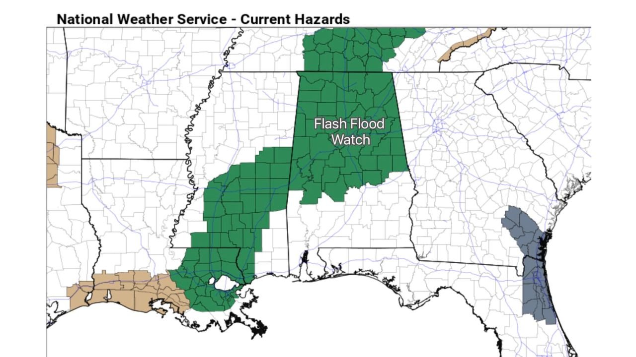
Flash Flood Watch Covers Northern and Central Alabama
According to current hazard maps, the northern half of Alabama is under a Flash Flood Watch, where repeated rounds of rain could lead to:
- Rapid runoff in urban and low-lying areas
- Rising creeks and streams
- Flooding of poor drainage locations and roadways
Rain is expected to move into the state early Friday morning, becoming widespread through the day and persisting into Saturday morning, especially across north and central Alabama.
Heavy Rainfall Totals Could Exceed 3 Inches in Some Areas
Seven-day precipitation guidance highlights a swath of heavier rainfall across central and northern Alabama, with localized totals approaching or exceeding 3 inches, and isolated spots potentially higher.
The rainfall intensity and duration increase the risk for flash flooding, particularly where storms repeatedly move over the same areas.
Isolated Strong to Severe Storms Cannot Be Ruled Out
While widespread severe weather is not expected, forecasters caution that a few strong to severe storms are possible, especially Friday.
Key points include:
- A relatively stable airmass should limit storm intensity overall
- If pockets of instability develop, isolated storms could produce strong wind gusts
- A brief, isolated tornado is possible, but not especially likely at this time
The overall severe threat remains low, with heavy rain being the dominant hazard.
Rain Shifts South by Saturday Afternoon, Threat Decreases
By Saturday afternoon, most of the rain is expected to shift into the southern half of Alabama, while conditions gradually improve from north to south.
As the system moves out:
- Rain tapers off across northern Alabama
- The severe weather risk drops significantly
- Flooding concerns diminish later in the day, though residual water may linger
Colder Air Arrives Saturday Night and Sunday
Behind the departing storm system, much colder air will surge into the Deep South, including Alabama, Saturday night into Sunday.
This colder air mass will bring:
- A noticeable temperature drop
- Clearing skies
- A return to drier, more stable conditions
The shift will mark a sharp contrast from the wet and unsettled weather experienced earlier in the weekend.
Bottom Line
Heavy rain and flash flooding are the main threats for Alabama through Saturday morning, particularly across the northern and central parts of the state, where 2 to 4 inches of rain may fall. While isolated strong storms are possible, the severe weather threat remains limited.
Residents should monitor local forecasts, avoid flooded roadways, and remain weather-aware through the weekend.
WaldronNews.com will continue providing updates as conditions evolve and any additional advisories are issued.