
Georgia, South Carolina, North Carolina, Virginia, Maryland, New Jersey, and New York See January 15–16 East Coast Storm Risk Weaken as Model Trends Shift, With January 18–20 Window Still Uncertain
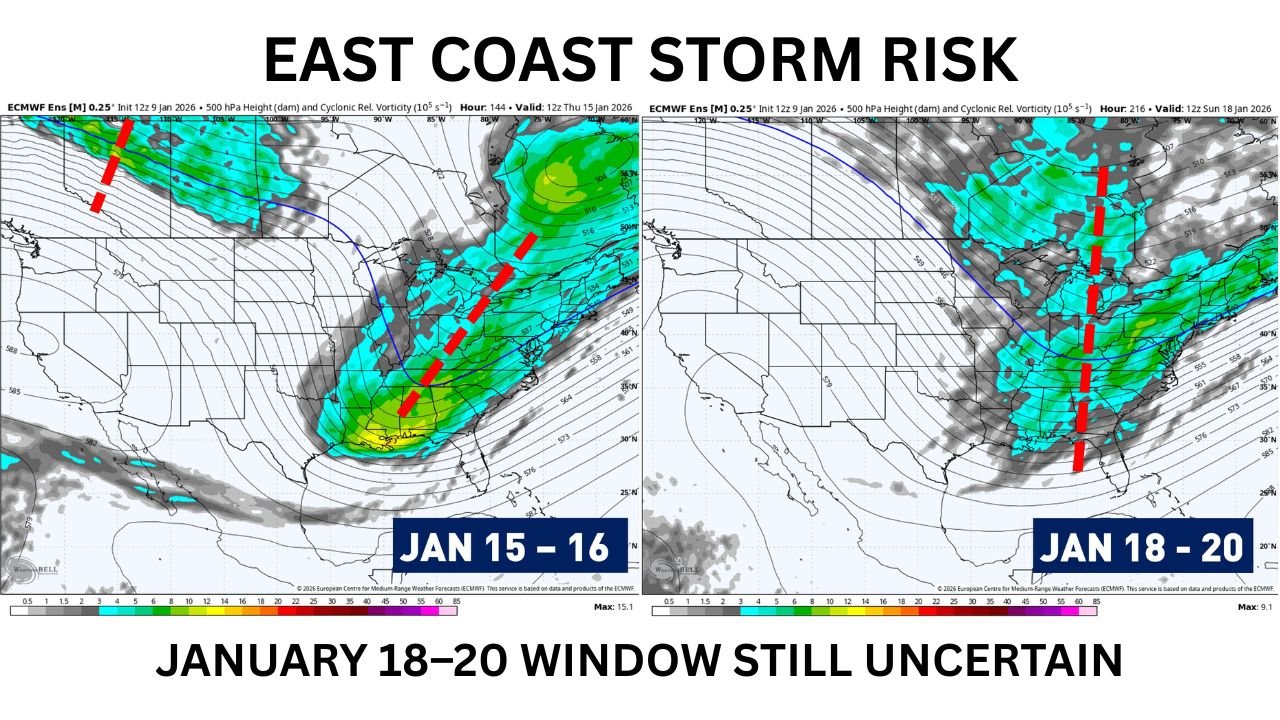
UNITED STATES — Updated ECMWF ensemble guidance indicates a notable shift in the mid-January winter pattern, with storm potential around January 15–16 becoming less favorable than earlier projections, while a secondary window from January 18–20 remains possible but highly uncertain. The latest data suggests increasing interference between upper-level waves, reducing the likelihood of a well-organized coastal winter storm during the first period.
Why the January 15–16 Setup Is Losing Support
Ensemble data shows the primary upper-level trough trending more positively tilted, a configuration that typically weakens surface development along the East Coast. Instead of a sharp, amplifying trough that supports rapid cyclogenesis, the atmosphere appears to be dealing with wave interference from a trailing longwave feature.
This interaction prevents the lead wave from slowing down and deepening efficiently. Without sufficient separation between these waves, storm energy struggles to consolidate near the coastline — a critical factor for significant snow events from the Mid-Atlantic through New England.
Key impacted regions during this period include:
- Southeastern states: Georgia, South Carolina, North Carolina
- Mid-Atlantic: Virginia, Maryland, Delaware
- Northeast: Pennsylvania, New Jersey, New York, southern New England
At this stage, the January 15–16 system looks more likely to produce scattered light precipitation or inland snow bands, rather than a classic coastal snowstorm.
Exception Scenario: What Would Need to Change
There remains a narrow pathway for a more impactful outcome. If upcoming model runs show:
- Increased spacing between the lead wave and trailing longwave
- Slower progression of the lead disturbance
- Stronger amplification near the Southeast coast
then a coastal storm track could still emerge. However, ensemble consensus currently does not strongly support this outcome.
January 18–20: A Second Wave Worth Monitoring
While farther out in time, ensemble guidance introduces a second upper-level wave between January 18–20. This feature appears better defined in some members but remains highly variable in track, strength, and timing.
This later window could impact:
- Deep South: Alabama, Mississippi, Georgia
- Tennessee Valley: Tennessee, Kentucky
- Mid-Atlantic and Northeast: Virginia through New England
Because this wave is still several days away, run-to-run changes are expected, and deterministic model hype should be treated cautiously. Ensemble trends — not single runs — will determine whether this system evolves into a meaningful winter storm.
Bottom Line: Snow Still Likely Somewhere on the East Coast
Despite the weakening signal for January 15–16, the broader pattern remains supportive of at least one light to moderate snowfall event somewhere along the East Coast over the next two weeks. Persistent troughing, cold air availability, and multiple shortwaves ensure winter is far from finished.
Forecasters emphasize patience as the atmosphere continues to sort out wave timing and interaction. The overall message from ensemble guidance is clear: ignore short-term hype, but stay alert — winter still has opportunities left on the table.
What are you seeing in your area — colder air, early flakes, or just model watching? Share your local conditions and thoughts, and keep following Waldron for clear, data-driven winter weather updates as the pattern evolves.