
Pennsylvania, Maryland, New Jersey, and Delaware Under Winter Weather Advisory as Saturday Morning Snow Brips 1–3 Inches
NEW JERSEY — Confidence has increased that a light but impactful snow event will affect parts of the Mid-Atlantic early Saturday, prompting a Winter Weather Advisory for south-central Pennsylvania and raising travel concerns across nearby portions of Maryland, New Jersey, and Delaware.
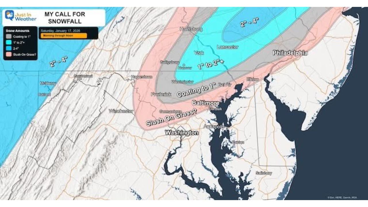
Forecast data from the National Weather Service shows the highest likelihood for accumulating snow north and west of the I-95 corridor, while coastal and southern areas are more likely to see rain or a brief mix. While snowfall totals remain modest, timing during the Saturday morning hours could lead to slippery roads and reduced visibility.
Winter Weather Advisory Issued for South-Central Pennsylvania
A Winter Weather Advisory is in effect from 5 AM to 12 PM Saturday for parts of south-central Pennsylvania, including areas around Harrisburg, York, and Lancaster.
Expected snowfall totals include:
- 1 to 3 inches of snow in advisory areas
- Snow developing early Saturday morning, tapering off by midday
- Road stickage likely, especially on untreated roads, bridges, and overpasses
Forecasters note that temperatures near freezing will allow snow to accumulate quickly during heavier bursts, even if totals remain on the lower end.
Snow Potential Extends Into Northern Maryland
Parts of northern Maryland are expected to see light snow accumulation, particularly near the Pennsylvania border.
Key concerns for Maryland include:
- Coating to around 1 inch of snow in northern counties
- Snow mixing with rain farther south toward the Baltimore and Washington corridor
- Slushy conditions on grassy surfaces and secondary roads
While Maryland is not under an advisory at this time, officials caution that brief travel impacts are still possible during the morning hours.
New Jersey and Delaware: Snow Inland, Rain Near the Coast
In New Jersey, snow chances increase north and west of I-95, with lighter totals closer to the coast.
New Jersey forecast highlights:
- 1–2 inches possible in northwest and interior sections
- Mostly rain or a rain/snow mix near the coast and southern counties
- Reduced snow confidence closer to the shoreline
In Delaware, snowfall potential remains very limited, with most locations expected to see rain or little to no accumulation, especially near the coast.
Sunday Snow Remains Highly Uncertain
While some forecast models suggest a low-confidence chance of snow on Sunday, meteorologists stress that storm track and moisture placement remain unclear.
At this time:
- Confidence in Sunday snow totals is very low
- Any snow would likely be light and localized
- Forecast focus remains on Saturday morning impacts
Residents are advised to monitor updates closely as forecast confidence improves.
What Residents Should Know
- Greatest snow impacts: South-central Pennsylvania
- Best timing: Early Saturday morning (5 AM–12 PM)
- Primary hazard: Slippery roads during the morning commute
- Snow totals: Generally 1–3 inches, highest north and west of I-95
What Happens Next
Forecasters will continue refining snowfall expectations overnight. Even small accumulations can cause outsized impacts when snow falls during peak travel hours.
Stay alert, slow down on the roads, and check the latest local forecasts before heading out Saturday morning.
For continued updates, local weather breakdowns, and developing winter alerts, stay with Waldron News.