
Missouri and Illinois Face Another Brief Round of Snow This Afternoon as Slick Road Conditions Develop
MISSOURI & ILLINOIS — A quick-moving round of snowfall is expected to impact parts of eastern Missouri and southwest Illinois later this afternoon, bringing the potential for slick travel conditions, especially on bridges, overpasses, and elevated roadways, according to the National Weather Service in St. Louis.
Forecasters stress that while this snow event is not expected to be highly disruptive, drivers commuting later today should exercise extra caution, as even light snow can quickly create hazardous conditions when temperatures remain near or below freezing.
Timing: When Snow Is Expected
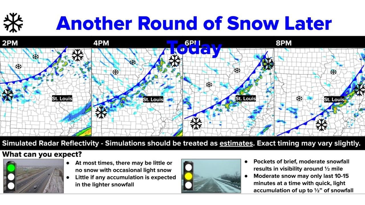
Based on the latest simulated radar and short-term models, snowfall will move through the region in multiple narrow bands rather than a steady shield of snow.
Expected timeline:
- Early to mid-afternoon: Snow showers begin developing west of the St. Louis metro
- Late afternoon to early evening: Snow bands sweep east across Missouri into Illinois
- By late evening: Most activity exits the region
Because the snow will be intermittent and fast-moving, conditions may change rapidly over short distances.
Snowfall Amounts: Light but Impactful
Accumulation totals are expected to remain light, but impacts may still be noticeable due to cold pavement temperatures.
What to expect:
- Little to no accumulation in many locations
- Brief coatings possible during heavier snow bursts
- Up to ½ inch of quick accumulation in isolated spots
The National Weather Service notes that moderate snow bursts may last only 10 to 15 minutes, but can briefly reduce visibility to around one-half mile.
Travel Concerns: Where Conditions Could Turn Slick
Even small amounts of snow can cause problems when surfaces cool rapidly.
Drivers should be especially cautious:
- On bridges and overpasses
- Along untreated secondary roads
- During evening commute hours
- In areas that experience sudden heavier snow bands
Roads may appear merely wet, but black ice and quick refreezing are possible as snow ends.
Why This Snow Matters Despite Low Totals
Meteorologists emphasize that this event is less about totals and more about timing and temperature.
Key factors increasing impact:
- Cold air already in place
- Pavement temperatures near freezing
- Snow falling during peak travel hours
- Narrow bands producing sudden bursts of snow
This combination increases the risk of unexpected slick spots, even if snow amounts remain minimal.
Looking Ahead: Cold Pattern Continues
This round of snow is part of a broader cold pattern affecting much of the eastern United States. Additional surges of colder air are expected this weekend, keeping winter weather concerns ongoing across Missouri and Illinois.
Residents are encouraged to remain weather-aware and monitor local forecasts for any updates if conditions change.
What You Should Do Today
- Slow down and increase following distance if driving
- Watch for rapidly changing road conditions
- Allow extra travel time this afternoon and evening
- Remain alert even if snow appears light
Waldron readers can expect continued updates as winter weather patterns evolve. Share how conditions look in your area and stay prepared as winter remains firmly in control.