
Georgia Winter Weather Alert Snow and Slick Roads Expected South of I-85 as Arctic Air Grips Central and Southern Georgia
GEORGIA — A burst of winter weather is impacting central and southern Georgia this morning as colder air pushes into the region, allowing rain to transition into snow and creating hazardous travel conditions across several counties, especially south of the I-85 corridor.
Forecasters say this is a short-duration but impactful event, with snow falling during the morning hours and lingering effects on roads through early afternoon.
Where Snow Is Falling and How Much to Expect
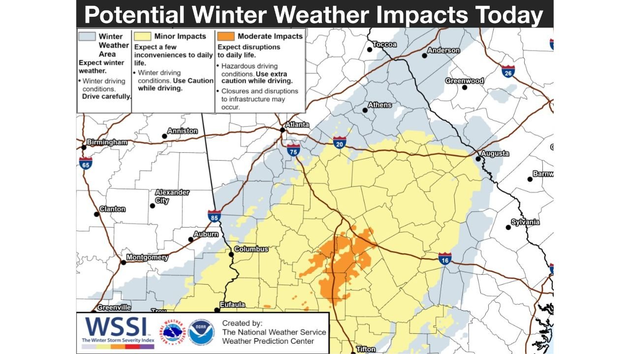
Weather data shows a narrow but active band of snow setting up across central Georgia, with the most noticeable impacts stretching across areas south of Atlanta toward Macon, Columbus, and surrounding counties.
Expected snowfall totals include:
- Trace to 1 inch across much of central Georgia
- 1 to 2 inches across metro-adjacent and southern counties
- Isolated pockets near 3 inches in parts of south-central Georgia where snowfall rates briefly intensify
While totals may appear modest, temperatures hovering near or below freezing are increasing the risk of slick roadways.
Timing: When Conditions Are Most Dangerous
The main window for impactful weather is between 6 a.m. and 2 p.m., according to updated forecasts.
Key timing details include:
- Rain transitioning to snow during the early morning
- Heavier snow bands possible late morning
- Gradual clearing expected between 2 p.m. and 4 p.m.
- Lingering slick spots possible after snowfall ends
Visibility may briefly drop during heavier snow bursts, particularly in open or elevated areas.
Travel Concerns Focus on I-75 and I-16 Corridors
Transportation officials are urging caution, especially along Interstate 75 and Interstate 16 south of Macon, where snow-covered or icy patches could develop quickly.
Drivers should expect:
- Slower traffic speeds
- Potential delays during the morning commute
- Increased risk on bridges, overpasses, and untreated roads
Officials recommend delaying travel until later this afternoon or evening if possible, when conditions improve.
Why This Event Is Tricky Despite Light Snow Totals
Even though this is not a major winter storm, surface temperatures near freezing mean snow can accumulate on colder surfaces faster than expected. Sidewalks, parking lots, and secondary roads could become slick in a short time.
Forecasters stress that light snow in Georgia often poses outsized impacts due to limited winter road treatment and rapid temperature changes.
Safety Tips for Today
Residents across impacted areas are advised to:
- Drive slowly and increase following distance
- Avoid unnecessary travel during the morning hours
- Watch for icy patches, especially on bridges
- Allow extra time to reach destinations
Pedestrians should also use caution on sidewalks and steps, which may ice over quickly.
What Happens Next
Skies are expected to gradually clear later today, but colder air will remain in place tonight. Any moisture left on roadways could refreeze after sunset, especially in rural or shaded areas.
Stay alert for additional updates as conditions evolve through the day.
Have you seen snow or slick roads where you live? Share your local conditions and join the conversation on WaldronNews.com.