
Central and Eastern Oklahoma See Chaotic Mix of Snow, Sleet, and Freezing Rain as Warm Layer Aloft Disrupts Winter Setup
OKLAHOMA — Winter weather across central and eastern Oklahoma turned highly complex and messy this evening as a shallow warm layer above the surface disrupted what would otherwise be a straightforward snow event, leading to a rapidly changing mix of snow, sleet, and pockets of freezing rain.
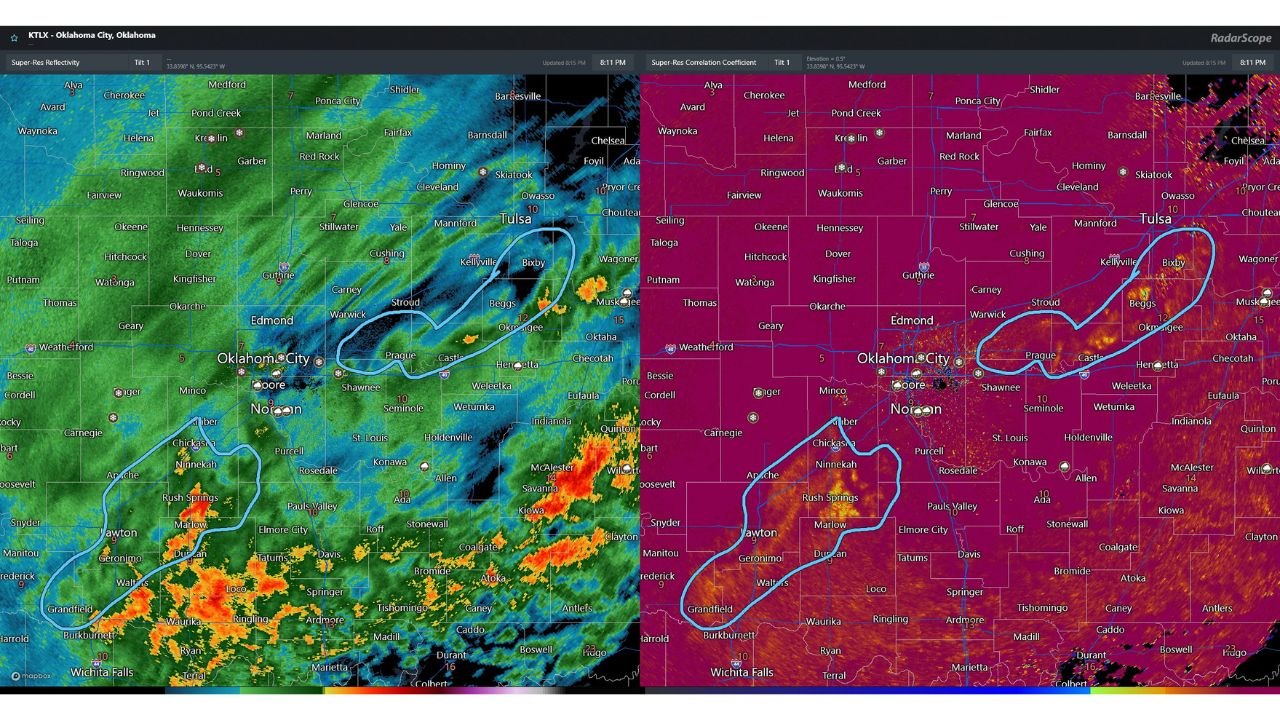
Meteorologists caution that this setup is difficult for standard precipitation-type algorithms to depict accurately, making radar analysis, soundings, and ground truth reports critical to understanding what is actually falling.
Why Radar Algorithms Are Struggling Tonight
Dual-pol radar data shows lower correlation coefficient values across parts of central and eastern Oklahoma, signaling mixed hydrometeor shapes rather than uniform snow crystals. This aligns with reports of sleet and freezing rain embedded within broader snow areas.
Correlation coefficient values closer to one typically indicate homogeneous precipitation such as snow. Tonight’s radar scans instead reveal irregular values, confirming a transition zone where precipitation types are overlapping and evolving in real time.
Warm Nose Aloft Is the Key Disruptor
The 00Z upper-air sounding from Norman, Oklahoma revealed a slight warm nose above the freezing level, allowing snowflakes to partially melt before refreezing near the surface.
This vertical temperature profile supports:
- Snow melting aloft into raindrops
- Refreezing into sleet before reaching the ground
- Occasional freezing rain where surface temperatures remain below freezing
This explains why nearby locations are reporting different precipitation types at the same time, even within short distances.
Ground Reports Confirm the Mixed Reality
mPING reports across central and eastern Oklahoma have confirmed:
- Snow
- Sleet
- Freezing rain
These reports closely match radar and sounding data, reinforcing that this is not a model error, but rather a physically messy atmosphere struggling to settle into a single precipitation phase.
Change Expected as Colder Air Deepens
While conditions are disorganized this evening, meteorologists expect colder air to deepen above the surface overnight, eroding the warm layer aloft.
As this happens:
- Sleet and freezing rain should gradually diminish
- Precipitation should transition back to mostly snow
- Radar signatures should become more uniform
The timing of this transition may vary by location, but the overall trend favors snow dominance later tonight.
Travel Impacts Remain Unpredictable
Because sleet and freezing rain can occur suddenly and briefly:
- Road conditions may deteriorate faster than expected
- Treated surfaces may still ice over
- Visibility can fluctuate rapidly during heavier bursts
Drivers are urged to use caution, especially in areas where precipitation type may not match radar snowfall estimates.
Bottom Line
Central and eastern Oklahoma are experiencing a highly variable winter weather event driven by a shallow warm layer aloft. Snow, sleet, and freezing rain are all occurring this evening, but colder air moving in should gradually push precipitation back toward snow overnight.
Until then, conditions will remain messy, uneven, and difficult to forecast at street level — a classic example of why winter weather can be more disruptive than it appears on a map.
Stay with WaldronNews for real-time radar analysis, updated winter weather impacts, and overnight precipitation changes across Oklahoma. Share your local conditions and travel reports to help others stay informed.