
Warm Air Aloft Advances Toward Southern New England, Setting Up Snow-to-Sleet Transition as Coastal Line Holds the Key
SOUTHERN NEW ENGLAND — Forecasters are closely tracking a developing warm layer aloft — known as a “warm nose” — advancing northward above subfreezing surface air, a classic setup that often determines whether a winter storm remains snow or transitions to sleet near the coast. The latest mesoscale analysis shows the warm nose already on the move, with the only remaining question being how far inland it penetrates.
The outcome will play a major role in final snow totals and ice impacts, especially for coastal and near-coastal areas of southern New England.
What the 850mb Data Shows Right Now
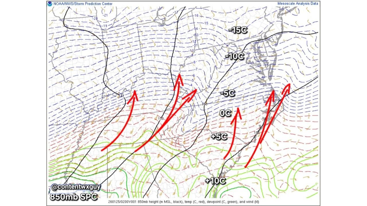
At the 850mb level (roughly 5,000 feet above ground), temperature gradients are tightening rapidly from south to north:
- +10°C air remains well offshore, south of New England
- +5°C to 0°C air is pressing northward toward the coastline
- Sub-freezing air (-5°C to -10°C) holds firm inland
This vertical temperature structure strongly favors initial snow across the region, followed by sleet developing from south to north once the warm nose reaches critical depth.
Does the Warm Nose “Kiss” the Coast — or Push Inland?
That is the defining forecast question.
- If the warm nose stalls near the immediate coastline:
- Coastal areas briefly mix with sleet
- Interior southern New England remains all snow
- Higher snow totals persist inland
- If the warm nose pushes inland 20–40 miles:
- Snow transitions to sleet for coastal plain and I-95 corridor
- Snow totals are reduced near the coast
- Ice accumulation risk increases, especially overnight
Importantly, by the time sleet begins, most areas will have already accumulated significant snowfall, limiting the overall damage to snow totals — but not necessarily to travel conditions.
Why Sleet Becomes Likely Late in the Event
Even a shallow layer above freezing aloft is enough to:
- Melt falling snow into raindrops
- Allow refreezing into sleet as it falls back into colder air below
This setup is classic for heavy, compact snow first, followed by pellet sleet that quickly degrades road conditions without the tree-crushing impacts of freezing rain.
Bottom Line for Southern New England
- Snow dominates early across the entire region
- Sleet intrusion depends on how far north warm air advances aloft
- Interior locations likely stay mostly snow
- Coastal and near-coastal areas face the highest risk of snow mixing with sleet late
Small shifts in the warm nose track will make a big difference over short distances, especially within a few counties of the coast.
Stay with WaldronNews for continued mesoscale analysis, snow-to-sleet timing updates, and precise impact forecasts as this winter storm evolves across Southern New England. Share local observations to help refine real-time coverage.