
Mississippi, Alabama, Georgia, and Florida Face Damaging Winds and Tornado Risk as Fast-Moving Squall Line Sweeps Southeast on January 25
UNITED STATES — A fast-moving but potentially dangerous severe weather setup is unfolding across the Southeast on Sunday, January 25, 2026, as an advancing cold front drives a widespread line of strong to severe thunderstorms from the lower Mississippi Valley into the Deep South and Florida Panhandle.
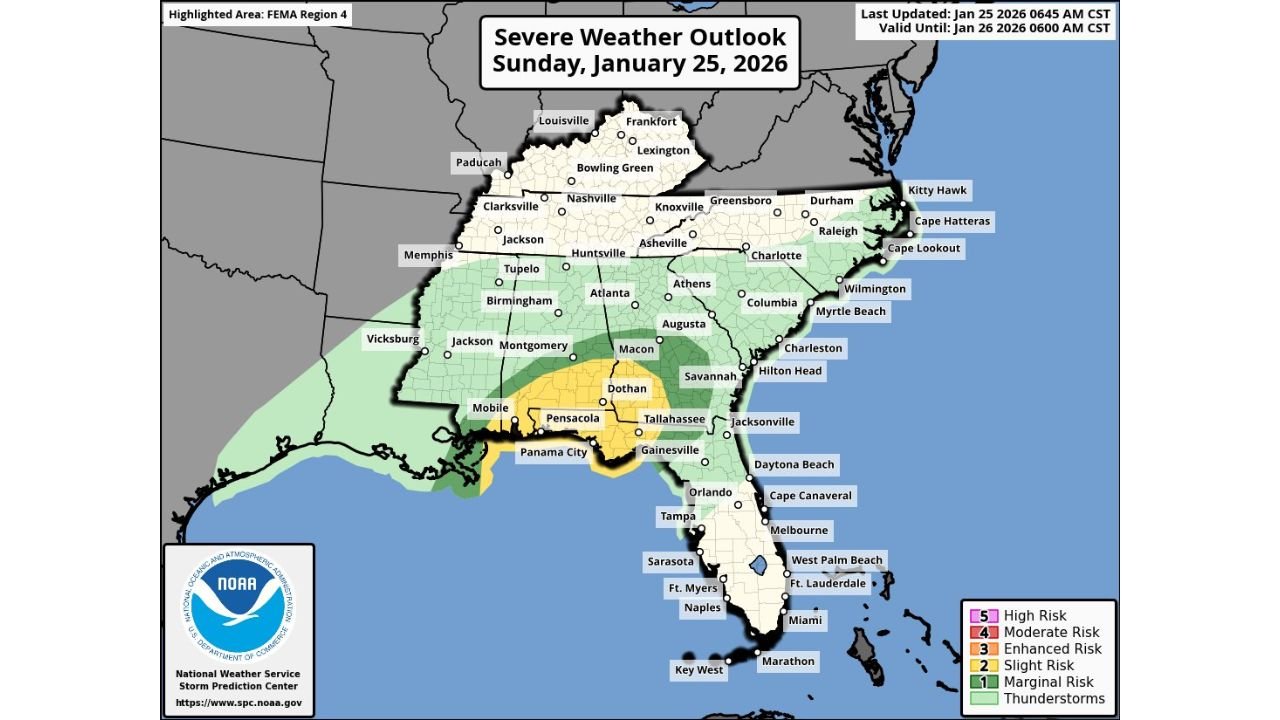
Forecast data and the latest Storm Prediction Center outlook show a Slight Risk (Level 2 of 5) for severe weather stretching from far southern Mississippi through southern Alabama, southwest Georgia, and the Florida Panhandle, with surrounding areas under a broader Marginal Risk for strong storms.
What’s Driving Today’s Severe Weather Threat
Meteorological analysis indicates an eastward-surging cold front colliding with warm, unstable air across the Gulf Coast states. As the front advances late morning into the afternoon, thunderstorms are expected to rapidly organize into a well-defined squall line.
Strong low-level wind shear ahead of the front will enhance storm intensity, increasing the risk for:
- Damaging straight-line winds
- Brief, embedded tornadoes
- Widespread lightning and heavy downpours
While isolated supercell storms may develop ahead of the main line within the warm sector, forecasters note that the fast-moving nature of the system should limit how long individual storms can intensify before being overtaken by the squall line.
Primary Impact Zone
The highest confidence for severe impacts is focused across:
- Southern Mississippi
- Southern and central Alabama
- Southwest Georgia
- Florida Panhandle, including coastal and inland communities
Cities such as Mobile, Pensacola, Panama City, Dothan, Tallahassee, and nearby areas are particularly well-positioned for strong wind gusts as the line moves through.
Timing and Evolution
- Late Morning: Thunderstorms begin organizing along the cold front over Mississippi and Alabama
- Midday to Afternoon: Rapid intensification into a solid squall line with damaging wind potential
- Afternoon to Early Evening: Line sweeps east across Georgia and the Florida Panhandle before gradually weakening
The main severe threat is expected to come from the squall line itself, rather than from long-lived discrete supercells.
Why Even a “Slight Risk” Matters
Although the overall risk category is not extreme, Slight Risk events in the Southeast frequently produce tornadoes, especially within fast-moving lines where brief spin-ups can occur with little warning.
Residents are urged to:
- Stay alert for severe thunderstorm and tornado warnings
- Have multiple ways to receive alerts
- Secure loose outdoor items
- Avoid travel during the strongest storms if possible
Bottom Line
Sunday’s setup favors widespread strong winds with a localized tornado risk, particularly from southern Mississippi through Alabama and into the Florida Panhandle. The speed of the system may reduce the duration of impacts, but it also means storms will move through quickly and forcefully.
Stay weather-aware and prepared as conditions evolve throughout the day.
What are conditions like where you live? Share updates and stay connected with the latest severe weather coverage at WaldronNews.com.