
Massachusetts, Connecticut, Rhode Island, New Hampshire, Vermont, New York, and Pennsylvania Dig Out as Heavy Snow Continues Overnight, Dry Slot Arrives, and More Snow Follows Monday
UNITED STATES — A powerful and long-duration winter storm is still impacting large portions of the Northeast as of Sunday evening, January 25, with moderate to heavy snowfall ongoing through midnight to as late as 2 a.m. across much of Massachusetts, Connecticut, Rhode Island, southern New Hampshire, Vermont, eastern New York, and northeastern Pennsylvania.
Radar and observational data show the storm’s final intense snowfall band moving through the region this evening, producing snowfall rates near or exceeding 1 inch per hour in spots. As of around 7:30–8:00 p.m., many communities have already reported 9 to 18 inches of accumulation, with additional snow still expected before a temporary lull develops overnight.
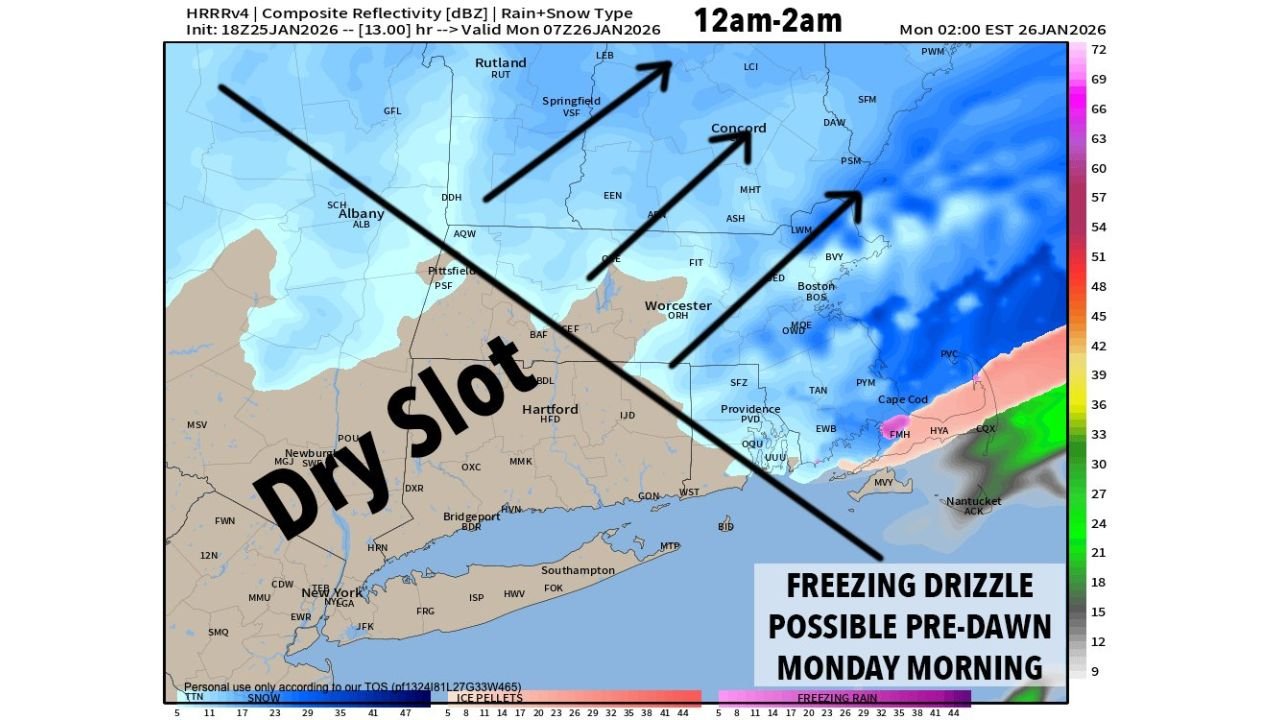
Heavy Snow Through Midnight, Then a Dry Slot
Through late evening and shortly after midnight, moderate to heavy snow will continue across most of interior southern New England and eastern New York. However, model guidance and radar trends confirm a dry slot punching northward after midnight as the storm center passes south of Nantucket and deepens offshore.
This dry slot will:
- Shut off the heaviest snow after midnight
- Lead to lighter snow showers, flurries, or patchy freezing drizzle
- Maintain slippery and icy road conditions overnight
The risk for freezing drizzle before dawn Monday is highest in parts of Connecticut, Rhode Island, eastern Massachusetts, and southeastern New York, where surface temperatures remain below freezing while precipitation becomes lighter.
Why Snow Totals Vary Across the Region
Snowfall distribution has not been uniform. Areas of western and central Massachusetts, northern Connecticut, and portions of eastern New York have seen higher totals due to stronger atmospheric lift producing fluffier dendritic snowflakes, which stack more efficiently.
Meanwhile, parts of the northern Berkshires, southern Vermont, and southwest New Hampshire have observed somewhat lower totals so far, despite similar precipitation amounts. In these zones, snowflakes have taken on plate, needle, and column shapes, which compact more and reduce overall accumulation depth.
Snow Returns in Pulses on Monday
Although the overnight dry slot brings a temporary break from heavy snow, the storm is not finished.
Forecast guidance shows:
- A pulse of light to moderate snow Monday morning
- A possible lull late morning
- A second round of steadier snow Monday afternoon into early evening
- Snow gradually tapering off Monday night
These additional periods of snow will add light but meaningful accumulation, especially across Massachusetts, Vermont, New Hampshire, eastern New York, and northern Connecticut.
Final Totals Still Being Tallied
Forecasters caution that final snowfall totals cannot be finalized until Monday night, once all phases of the storm have ended. Current expectations still support:
- 12 to 20 inches of snow across much of the region
- 18 to 24 inches or more in favored higher terrain areas
Bottom Line
This winter storm remains a multi-stage event, with heavy snow tonight, icy conditions overnight, and additional snowfall on Monday before fully winding down. Travel will remain hazardous through at least Monday evening, and residents should continue to allow extra time and monitor conditions closely.
Have snow totals or local conditions to report? Share your updates and stay with WaldronNews.com for continued storm coverage and final accumulation reports.