
Tampa, Florida, Could See Snow Showers as Rare Arctic Blast Reaches the Gulf Coast
FLORIDA — It’s a sentence few Floridians ever expect to read, but the data is backing it up: parts of the Tampa Bay area could see snow showers late Saturday night into early Sunday as an unusually strong Arctic air mass crashes into Florida behind a powerful cold front.
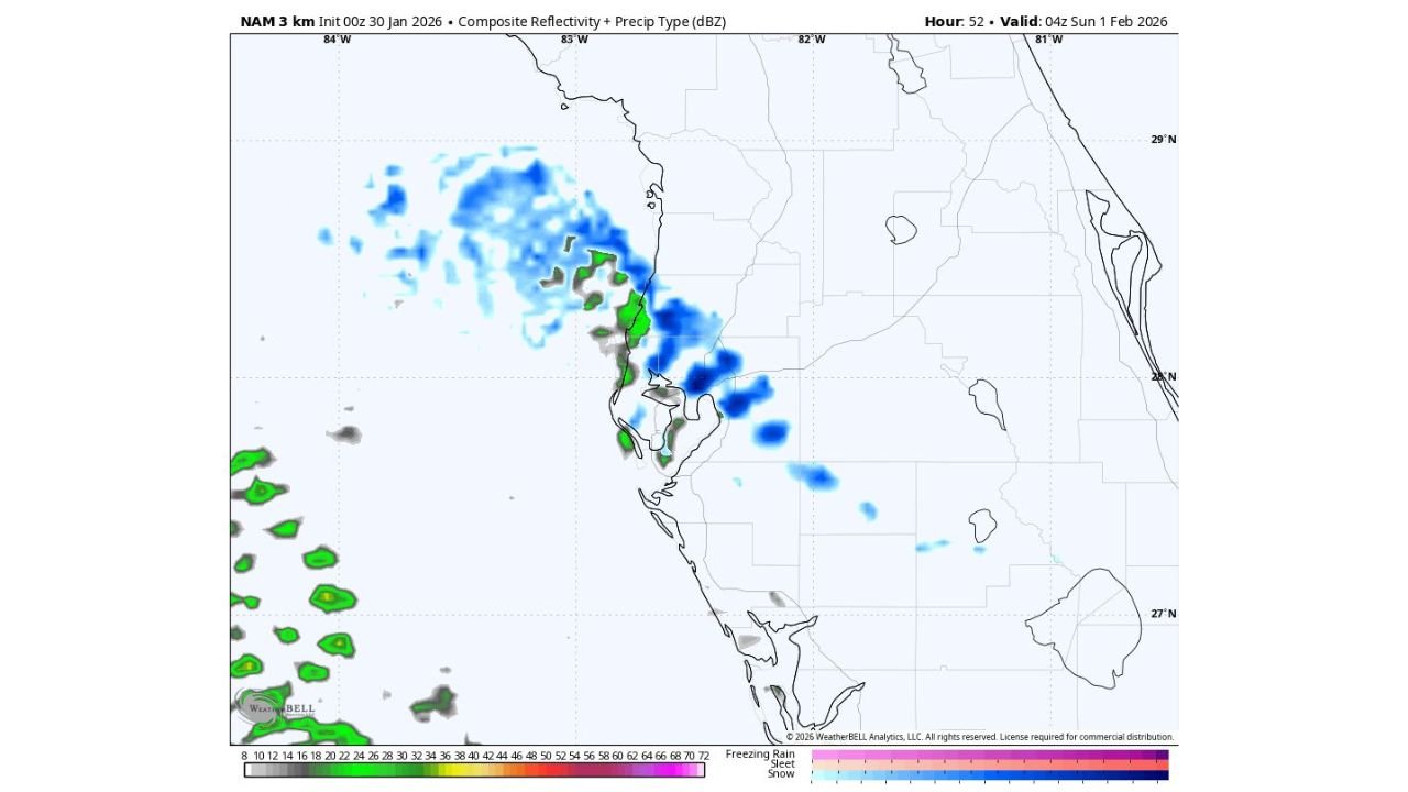
High-resolution NAM 3-km model guidance shows bands of precipitation developing over the eastern Gulf of Mexico and pushing inland toward Tampa, St. Petersburg, and nearby coastal communities, with thermal profiles cold enough to briefly support snow or snow-rain mix, especially during the overnight hours.
What the Models Are Showing
The latest guidance indicates:
- Arctic air pouring straight south into Florida, with minimal modification
- Cold winds crossing the warm Gulf waters, creating “ocean-effect” snow showers
- Light but organized precipitation bands moving onshore near Tampa Bay
- Snow indicated aloft, with surface temperatures marginal but briefly cold enough for flakes
While accumulation is unlikely due to warm ground temperatures, the setup strongly supports at least the possibility of visible snowflakes, which would be a historic sight for the region.
Why This Setup Is So Rare for Tampa
Several extreme factors are aligning at once:
- Direct North Pole–to–Florida air trajectory, shown in backward trajectory analysis
- Exceptionally cold upper-level temperatures
- Strong pressure gradient behind the Arctic front
- Moisture pickup from the Gulf, enhancing convective snow bands
This is not a typical cold snap — it’s the kind of setup usually reserved for once-in-a-generation events in Florida.
Timing for the Tampa Bay Area
- Saturday evening: Arctic front clears the region
- Late Saturday night: Coldest air arrives; snow showers possible
- Early Sunday morning: Brief window for flakes before precipitation ends
- Sunday sunrise: Bitter cold, wind chills near record levels
Wind chills could fall into the single digits in parts of Central Florida, an almost unheard-of value for the region.
What Residents Should Expect
- Possible snow flurries or brief snow showers
- Hard freeze conditions inland
- Strong, biting winds
- No meaningful snow accumulation expected
- High chance of viral moments if flakes appear
Even if snow doesn’t reach the ground everywhere, the atmospheric conditions alone are historic.
Bottom Line
Snow in Tampa is rare. Snow with Arctic air this intense is extraordinary.
While this will not be a traditional snowstorm, the mere presence of snow showers in the Tampa Bay forecast underscores just how extreme this cold outbreak is.
WaldronNews will continue tracking updates, model trends, and real-time observations as this unprecedented Florida cold event unfolds.
Stay with WaldronNews for breaking winter weather updates from Florida, the Southeast, and across the United States.