
North Carolina–South Carolina Winter Storm Drops Double-Digit Snow Near State Line, With Pender County Among Hardest Hit
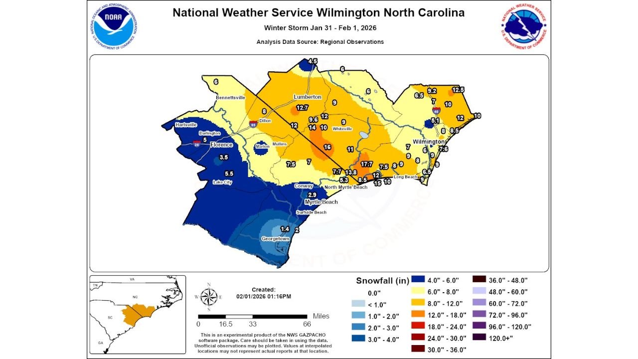
UNITED STATES — A powerful winter storm that swept through southeastern North Carolina and northeastern South Carolina between January 31 and February 1, 2026, delivered a striking gradient of snowfall totals, with the heaviest accumulations concentrated along and just north of the NC–SC state line, according to newly released National Weather Service analysis data.
Snowfall reports compiled from regional observations show that while coastal and far-southern areas saw lighter totals, a narrow inland corridor experienced significantly higher snowfall, creating sharp contrasts over relatively short distances.
Heaviest Snow Focused Along the NC–SC State Line
The latest snowfall map from NWS Wilmington, North Carolina, clearly highlights a band of double-digit snow totals stretching from northeastern South Carolina into southeastern North Carolina, following the general orientation of the state boundary.
- Portions of inland southeastern North Carolina recorded 12 to nearly 18 inches of snow, making this one of the more impactful winter events the region has seen in recent years.
- Snowfall amounts dropped off rapidly to the south and toward the immediate coastline, underscoring how localized the storm’s most intense band became.
Meteorologists note that this type of sharp cutoff is typical in Southern winter storms, where small shifts in storm track and temperature profiles can dramatically change outcomes.
Pender County Emerges as a Snowfall Standout
One of the most notable takeaways from the analysis is the performance of Pender County, North Carolina, which recorded some of the highest snowfall totals on the entire map.
- Several observation points in and around Pender County exceeded 15 inches, placing the area firmly within the storm’s core accumulation zone.
- Nearby inland communities also reported totals well into the 10–14 inch range, enough to significantly disrupt travel and daily activities.
In contrast, locations closer to the Atlantic coast—including parts of coastal New Hanover and Horry counties—generally saw lower but still impactful snowfall, often ranging from 6 to 9 inches.
Sharp Drop-Off Across Northeastern South Carolina
Across northeastern South Carolina, snowfall totals showed a clear southward decrease:
- Inland areas near the state line reported 7 to 10 inches of snow.
- Farther south toward Georgetown County, totals tapered to 1 to 3 inches, with some spots seeing even less.
This gradient reflects warmer surface temperatures and marginal mixing closer to the coast, which limited accumulation despite steady precipitation during the event.
Community Reports Helped Refine the Final Map
Forecasters credited public snowfall reports for helping refine the final accumulation analysis. Residents across both states submitted measurements—many with photo documentation—that allowed meteorologists to better resolve localized maxima and minima.
Officials encouraged continued public participation in future events, noting that real-time reports are especially valuable in complex Southern winter storms where radar estimates alone can fall short.
Cold Conditions Linger After the Storm
While snowfall has ended, cold air remains firmly in place across the Carolinas, allowing snowpack to persist longer than usual for early February. Overnight refreezing is expected to continue over the next several days, increasing the risk of slick roads during morning and nighttime hours.
Residents are advised to remain cautious, especially on secondary roads and shaded areas where snow and ice may linger.
Have photos or snowfall totals from this storm in your area? Share your experience and stay connected with ongoing weather updates at Waldronnews.com.