
Morgantown, Clarksburg, and Davis Face Evening Commute Snow as Winter Weather Advisory Targets Northern West Virginia Tuesday
UNITED STATES — Another quick-moving round of winter weather is expected to impact parts of the central Appalachians on Tuesday, with northern West Virginia communities including Morgantown, Clarksburg, and Davis facing the greatest risk for travel disruptions, according to forecast guidance from the National Weather Service in Pittsburgh.
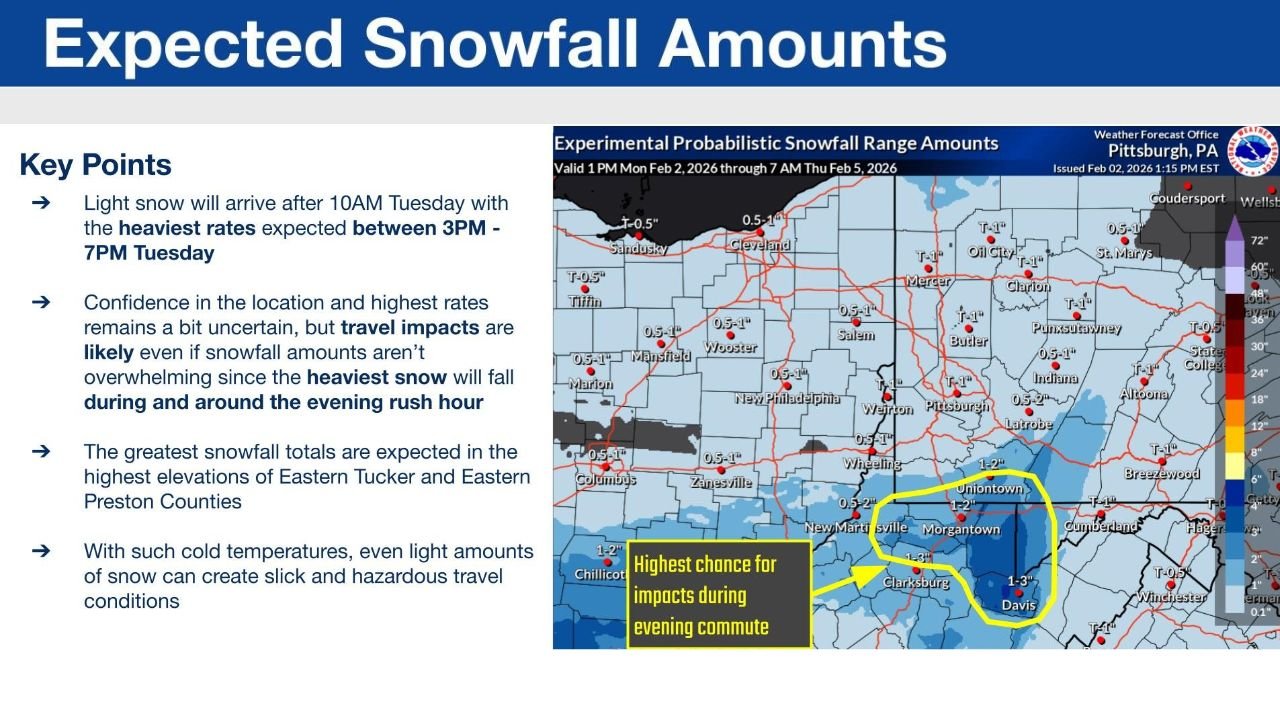
A Winter Weather Advisory is in effect from 10 a.m. Tuesday until 1 a.m. Wednesday for portions of northern West Virginia, as light snow develops late in the morning and intensifies during the afternoon and evening hours.
Snow Develops Late Morning Ahead of Evening Commute
Forecast data shows light snow arriving after 10 a.m. Tuesday, gradually expanding across the region. Snowfall rates are expected to increase later in the day, with the heaviest snow forecast between 3 p.m. and 7 p.m., directly overlapping with the evening commute.
While overall snowfall amounts are not expected to be high, the timing of the snow is the primary concern, increasing the likelihood of slippery roads during peak travel hours.
Northern West Virginia Corridor Most Impacted
The highest probability of impactful snowfall is centered across northern West Virginia, with a highlighted zone extending through Morgantown, Clarksburg, and Davis. Forecast snowfall totals in this corridor generally range from 1 to 3 inches, with localized higher amounts possible in elevated terrain.
Nearby areas in western Pennsylvania and eastern Ohio may see lighter snow, but the most consistent accumulation and travel impacts are expected south of Pittsburgh and east of the Ohio River, focused squarely on northern West Virginia.
Higher Elevations in Tucker and Preston Counties at Greater Risk
The forecast indicates that the greatest snowfall totals are expected in the higher elevations, particularly in eastern Tucker County and eastern Preston County. Elevation-enhanced snowfall could allow accumulations to increase more quickly in these areas compared to surrounding lowlands.
Roadways in these higher terrain locations may become snow-covered in a short period of time, especially during heavier bursts Tuesday afternoon and early evening.
Cold Temperatures Increase Hazard Potential
Despite relatively modest snow totals, cold surface temperatures will allow snow to stick immediately, increasing the risk of slick roads. The National Weather Service warns that even light snow amounts may lead to hazardous travel conditions, particularly during periods of higher snowfall rates.
Forecast confidence in the exact placement of the heaviest snow remains somewhat uncertain, but travel impacts are still considered likely due to the combination of timing, cold conditions, and snowfall intensity.
Short-Duration Event With High Travel Impact
Snow is expected to taper off later Tuesday night, but the overlap with rush hour means this system could have outsized impacts despite its short duration.
Drivers across northern West Virginia are encouraged to plan for slower travel Tuesday evening and remain alert for rapidly changing road conditions.
Stay with Waldronnews.com for continued updates on winter advisories, snowfall timing, and travel impacts across West Virginia and surrounding regions.