
Greenville, New Bern, Jacksonville, Washington, and Eastern North Carolina Shatter Snow Records With First Widespread 12-Inch Storm Since 1989
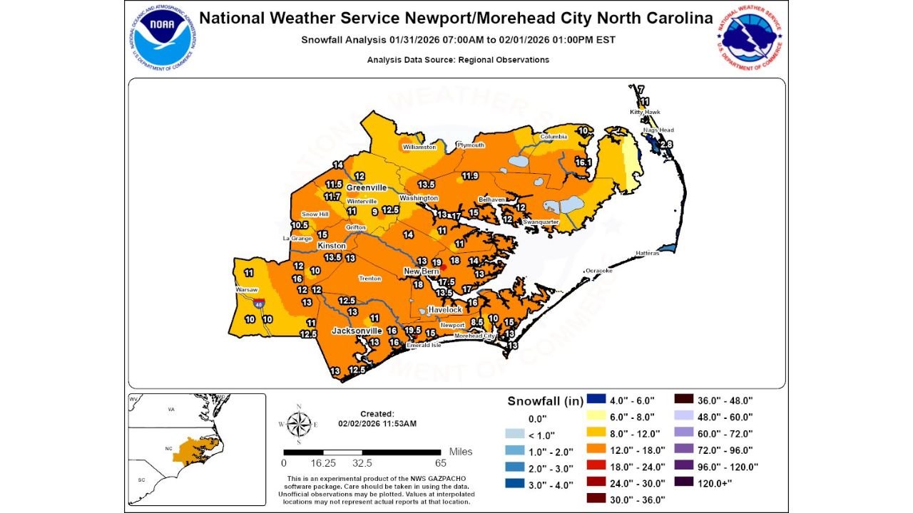
UNITED STATES — A historic winter storm delivered widespread snowfall exceeding 12 inches across Eastern North Carolina this past weekend, marking the region’s first broad 12-inch snow event since December 1989, according to snowfall analysis from the National Weather Service office in Newport/Morehead City.
The storm produced not only deep accumulations but also snow drifts reaching 2 to 4 feet in some locations, placing it among the most significant winter weather events in eastern North Carolina’s modern climate record.
Widespread Double-Digit Snowfall Across Eastern North Carolina
Snowfall analysis covering January 31 through February 1 shows extensive double-digit totals across a large portion of eastern North Carolina.
Communities reporting 12 inches or more of snow include:
- Greenville: approximately 11.5 to 11.7 inches
- Washington: around 13.5 inches
- New Bern: between 17 and 18 inches
- Jacksonville: near 16 inches
- Kinston: around 13 to 13.5 inches
- Havelock: approximately 16 inches
- Emerald Isle: close to 19.5 inches
Several inland and coastal counties recorded snowfall totals well into the 12 to 18-inch range, confirming that the storm was both widespread and intense.
Coastal and Crystal Coast Areas See Heavy Snow and Extreme Drifting
Along the Crystal Coast, snowfall totals generally ranged from 10 to 15 inches, with locally higher amounts inland from the immediate shoreline. While coastal locations saw slightly lower totals compared to interior zones, strong winds led to significant drifting, with snow piling 2 to 4 feet deep in spots.
The National Weather Service noted that while the March 1980 storm remains the benchmark, when 1 to 2 feet of snow fell regionwide and 20 to 30 inches accumulated along the Crystal Coast, this weekend’s event now stands as the most widespread heavy snowfall in more than three decades.
First Widespread 12-Inch Snow Since December 1989
Climatological context provided with the analysis confirms this was the first time since December 1989 that eastern North Carolina experienced such a large, continuous area of 12-inch snowfall.
While individual heavy snow events have occurred since then, none matched the breadth, depth, and consistency of this storm across the region.
A Landmark Winter Event for Eastern North Carolina
Snowstorms of this magnitude are extremely rare in eastern North Carolina, where winter precipitation typically falls as rain or mixed precipitation. The combination of deep snowfall, historic totals, and extreme drifting makes this storm a once-in-a-generation event for many communities.
For residents across Greenville, New Bern, Jacksonville, and surrounding areas, this storm will be remembered as one of the most impactful winter weather events in local history.
Stay with Waldronnews.com for continued coverage of historic winter storms, regional snowfall analysis, and major weather events across the United States.