
Historic Winter Storm Batters Carolinas, Southern Appalachians and Mid-Atlantic With Extreme Snowfall Differences
UNITED STATES — A powerful winter storm that moved across the Southern Appalachians, the Carolinas, and portions of the southern Mid-Atlantic between January 30 and February 1, 2026, left behind one of the most complex and memorable snowfall patterns the region has seen in decades, combining heavy snow, strong winds, and dramatic differences in accumulation over short distances.
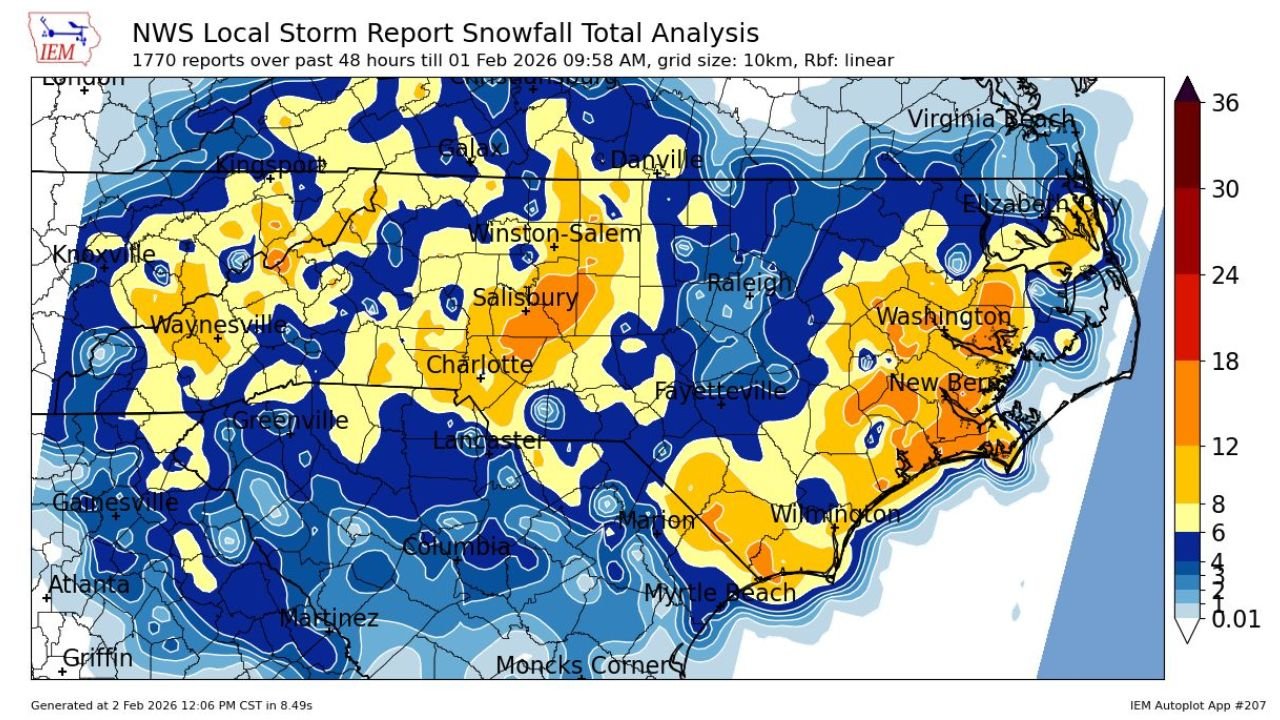
Final storm analyses compiled from National Weather Service Local Storm Reports and CoCoRaHS observations show that while snow fell across nearly the entire region, mesoscale banding led to sharply uneven totals, with some communities buried under more than a foot of snow while nearby areas saw far lower amounts.
Snowfall Totals Exceeded One Foot in Parts of North Carolina and Tennessee
The highest snowfall totals were concentrated across North Carolina, particularly from the western mountains through the Piedmont and into eastern sections of the state. Several communities reported totals that placed this storm among the most significant winter events since the late 1980s.
Notable snowfall reports included:
- Beaufort, North Carolina: 17.0 inches
- Kannapolis, North Carolina: 16.0 inches
- Greenville, North Carolina: 15.0 inches
- Pigeon Forge, Tennessee: 13.5 inches
- Winston-Salem, North Carolina: 11.0 inches
- Charlotte, North Carolina: 10.0 inches
- Greensboro, North Carolina: 10.0 inches
- Wilmington, North Carolina: 9.5 inches
- Elizabeth City, North Carolina: 9.3 inches
Snowfall totals gradually decreased moving south into South Carolina, though parts of the northern and eastern portions of the state still recorded 6 to 10 inches, while southern inland and coastal areas saw lighter accumulations.
Mesoscale Banding Created Sharp Snowfall Cutoffs
Meteorologists emphasized that intense mesoscale snow banding was the primary reason for the storm’s extreme variability. These narrow but powerful bands produced short bursts of heavy snowfall, causing sharp cutoffs in accumulation across neighboring towns and counties.
This effect was especially pronounced across:
- Central and eastern North Carolina
- The western and central Piedmont
- Areas near Charlotte, Salisbury, Winston-Salem, New Bern, and Wilmington
In some cases, snowfall totals doubled within a span of just a few miles, a hallmark of strong banding events.
Gusty Winds Added to Storm Impacts
In addition to heavy snow, the storm produced strong wind gusts that worsened travel conditions and contributed to blowing and drifting snow, particularly in open and coastal areas.
Selected wind gust reports included:
- Atlanta, Georgia: 63 mph
- Oregon Inlet, North Carolina: 58 mph
- Norfolk, Virginia: 55 mph
- Virginia Beach, Virginia: 56 mph
- Nags Head, North Carolina: 50 mph
The combination of wind and snow significantly reduced visibility during the storm’s peak, especially overnight and during heavier snow bands.
A Rare and Memorable Winter Event for the Region
For many communities, this storm marked the first widespread 12-inch snowfall since December 1989, with reports of snow drifts reaching 2 to 4 feet in isolated locations. While historic events such as the March 1980 storm remain the benchmark for extreme snowfall in the region, forecasters say this late-January storm stands out for its complex structure and widespread reach.
The storm’s impact stretched from the Southern Appalachians through the Carolinas and into the southern Mid-Atlantic, making it one of the most talked-about winter weather events in recent years.
Lingering Hazards Continue as Cleanup Begins
Although temperatures are beginning to moderate, officials warn that melting snow followed by overnight refreezing continues to create hazardous travel conditions, particularly during early morning and nighttime hours. Icy roads, reduced visibility, and lingering snowpack remain concerns across many affected areas.
Residents are encouraged to continue following local advisories and use caution as cleanup and recovery continue. For ongoing winter weather coverage, storm analysis, and regional impact updates, stay connected with Waldronnews.com.