
Valentine’s Day Weekend Winter Storm Signals Emerge Across Midwest and Ohio Valley as Models Hint at Snow, Ice, and Rain Mix
UNITED STATES — Meteorologists are beginning to closely monitor the potential for another winter storm around Valentine’s Day weekend, as early model guidance shows a developing system that could impact parts of the Midwest, Ohio Valley, and interior Northeast between February 13 and 15. While confidence remains low this far out, multiple forecast runs are now showing a similar signal — enough to put the period firmly on the weather watch list.
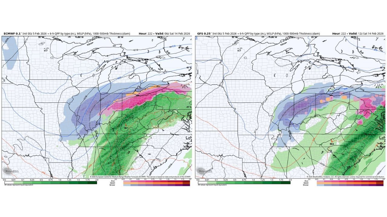
Forecast data suggests this system could arrive after a brief lull in winter activity, potentially bringing snow on the northwest side of the storm, mixed precipitation in transition zones, and rain farther south and east. Exact placement will depend heavily on storm track and temperature profiles, which are still evolving.
Early Model Guidance Shows Increasing Consistency
Recent long-range model runs, including both European and American guidance, are beginning to depict a organized precipitation shield developing over the central United States and lifting northeastward. In several scenarios, colder air holds on across the Upper Midwest and Great Lakes, allowing snow to develop on the northern flank of the system.
Farther south and east — across portions of the Ohio Valley, lower Great Lakes, and interior Mid-Atlantic — model depictions suggest a mix of snow, sleet, and freezing rain, depending on how quickly warmer air moves in aloft. These mixed-precipitation zones are often the most disruptive, even when snowfall totals are modest.
At this time, no single outcome is locked in, but the repetition of the signal across multiple model runs is what has forecasters paying attention.
Snow, Ice, and Rain All Possible Depending on Track
The developing pattern favors a classic late-winter setup, where relatively mild air to the south clashes with lingering cold air across northern states. If the storm tracks farther south, colder air could dominate and lead to more widespread snow. A farther north track would introduce warmer air, increasing the risk for sleet, freezing rain, or plain rain in southern areas.
Forecast maps currently show:
- Snow potential across parts of the Upper Midwest and Great Lakes
- Wintry mix risk through portions of the Ohio Valley
- Rain potential farther south and east
These details will change, but the overall message is clear — this is not a system to ignore.
Why It’s Too Early for Details — But Not Awareness
At 7–10 days out, forecast uncertainty remains high. Small shifts in the jet stream or surface low track can dramatically change outcomes for any given location. That’s why forecasters are stressing awareness rather than specifics at this stage.
However, the timing alone makes this system noteworthy. Valentine’s Day weekend often comes with increased travel, events, and gatherings — and winter weather during this window can cause significant travel disruptions, especially if snow or ice develops.
What Happens Next
Over the coming days, higher-resolution models will come into range, allowing meteorologists to:
- Better define storm track
- Clarify temperature profiles
- Identify snow vs. ice vs. rain zones
- Estimate potential impacts
If the signal continues to strengthen, more detailed forecasts and impact assessments will follow.
Stay connected with WaldronNews.com for continued updates as this potential Valentine’s Day weekend winter storm comes into clearer focus. We’ll break down what it could mean for travel, safety, and local impacts as confidence increases.