
Super Bowl Weekend Arctic Blast Targets Maryland and the Northeast as Clipper Storm Ushers in Dangerous Cold and High Winds
UNITED STATES — A powerful Arctic air mass is set to surge into the Northeast during Super Bowl weekend, bringing dangerously cold temperatures, strong winds, and a brief round of snow, particularly across Maryland, Pennsylvania, New Jersey, and the Mid-Atlantic coastline, according to the latest high-resolution model guidance.
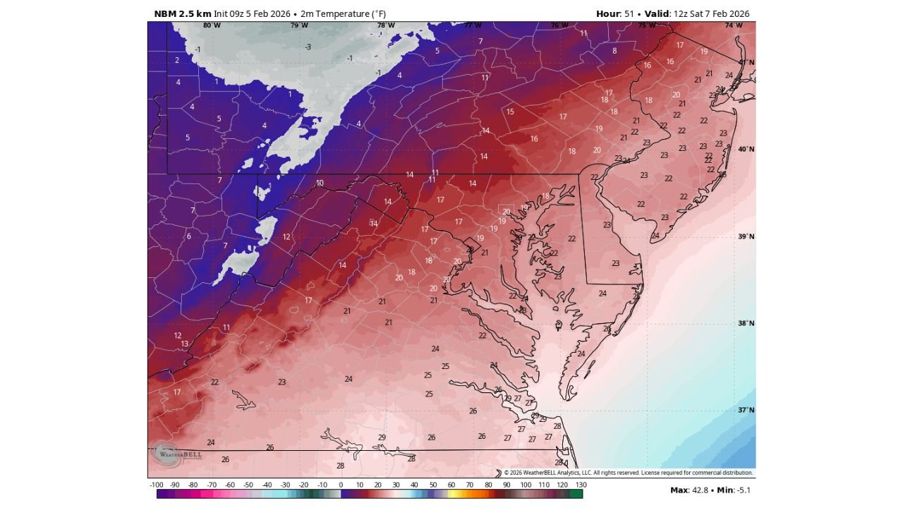
Forecast data shows a fast-moving clipper system crossing the region late Friday, followed closely by an intense Arctic front early Saturday, setting the stage for one of the coldest stretches so far this winter.
Light Snow Develops Friday as Clipper System Passes Through
Model guidance from RRFS and ECMWF indicates a narrow band of light snow developing Friday, primarily affecting:
- Central and northern Maryland
- Southern Pennsylvania
- Northern Virginia
- Parts of New Jersey and Delaware
Snowfall amounts appear limited, but brief accumulations are possible, especially north and west of Baltimore, where colder air is already in place. The snow band is expected to move quickly, reducing totals but creating short-term travel issues.
Arctic Front Arrives Early Saturday With Rapid Temperature Drop
Behind the clipper, an Arctic front barrels through early Saturday morning, triggering a sharp and rapid temperature fall across the Mid-Atlantic and Northeast.
- Morning temperatures may start near 20°F
- Temperatures then drop into the teens or lower
- Cold air deepens steadily through the day
By Saturday afternoon, temperatures struggle to recover, even under limited sunshine.
Wind Gusts 40–50 MPH Drive Wind Chills Below Zero
One of the most dangerous aspects of this setup is the wind. Behind the Arctic front:
- Sustained winds increase sharply
- Gusts reach 40 to 50 MPH
- Wind chills plunge below zero in exposed areas
NWS-calibrated apparent temperature data shows wind chills falling into the single digits below zero across interior Maryland and Pennsylvania, with coastal areas not far behind despite slightly milder air over the water.
Coastal Hazards Expected Along the Chesapeake Bay
Forecast guidance also highlights a marine hazard along the Chesapeake Bay and nearby tidal waterways.
Strong winds combined with rapidly falling air temperatures may produce “freezing spray”, where water droplets freeze on contact with surfaces. This can lead to:
- Icing on docks and vessels
- Hazardous conditions for marine operations
- Increased risk along exposed shoreline infrastructure
Residents and marine operators are urged to exercise caution, especially Saturday into early Sunday.
Bitter Cold Peaks Sunday Morning Across the Northeast
By Sunday morning, the Arctic air mass is fully entrenched.
Temperature guidance shows:
- Single-digit actual temperatures inland
- Wind chills well below zero
- Little relief until later Sunday afternoon
This air mass originates from far northern latitudes, with trajectory data confirming transport from near the Arctic region, reinforcing confidence in the severity of the cold.
Gradual Warm-Up Expected Next Week
The good news: this is not a long-lasting freeze.
Long-range guidance suggests:
- Moderating temperatures beginning early next week
- Winds easing by Monday
- Gradual return to near-seasonal conditions
However, the Super Bowl weekend period remains the most hazardous window, especially for outdoor plans, travel, and coastal activities.
Stay informed and prepared as this Arctic blast moves in. If you’re experiencing extreme cold, strong winds, or icy conditions in your area, share your local reports and photos — and keep following WaldronNews.com for continued updates, detailed forecasts, and developing weather coverage across the region.