
Colorado Front Range Forecast Turns “February Roller-Coaster” as Warm, Windy Days Give Way to a Midweek Pattern Shift
COLORADO — A stretch of dry, unusually warm February weather is taking hold across the Front Range and eastern plains, but meteorologists say the calm won’t last long. Forecast guidance points to a windy start to the week, followed by a cold front pushing temperatures down into the 40s and 50s by Tuesday, while mountain snow ramps up late Monday into Tuesday and continues on and off through the week.
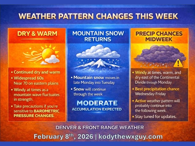
Dry and warm across the Front Range and eastern plains
The overall setup begins with sun and mild air spreading across much of Colorado, with widespread 60s expected and near-70° warmth possible on the eastern plains. That warmth comes with a tradeoff: periods of gusty wind as the “mountain wave” pattern strengthens and weakens.
If you’re someone who feels weather changes quickly—especially with barometric pressure swings—this is the type of pattern where it can help to hydrate, rest, and pace outdoor plans, because conditions may feel different from morning to afternoon.
Where the strongest winds are expected
While many neighborhoods will simply notice a breezy day, the forecast points to a few areas that can do better than the rest for stronger gusts.
The most favored corridor for higher gusts (roughly 25–45 mph through around midday) includes:
- The Cheyenne Ridge
- Parts of far northern Colorado
- Southeast Wyoming
- The western Nebraska Panhandle
Winds are expected to ease later in the day for many locations, but they can still kick up quickly in exposed areas—especially if you’re driving high-profile vehicles or traveling across open plains.
Cold front arrives, and Tuesday looks noticeably cooler
The bigger shift comes as a cold front approaches from the north late Monday into Tuesday. Forecast messaging suggests Monday could still sneak in a brief final warm push—possibly a degree or two warmer than expected in some spots—before the front arrives.
By Tuesday, temperatures are projected to drop back into the 40s and 50s, marking a clear reset from the springlike feel early in the week.
Mountain snow returns late Monday into Tuesday
The change in air mass also brings better odds for high-country snowfall. Snow is expected to develop late Monday into Tuesday along and west of the Continental Divide, and then continue intermittently through the week, with moderate accumulation possible through Friday.
This is particularly important because the pattern appears to favor the mountains, keeping the most consistent precipitation aimed at higher elevations rather than the lower valleys and plains.
The midweek window to watch: Wednesday through Friday
Looking farther out, the forecast highlights Wednesday through Friday as the best window for precipitation chances overall—though confidence on exact totals and precipitation type can still shift as newer model runs arrive.
What’s clearer right now is the theme: warm and dry east of the Divide through Monday, then cooler air Tuesday, while the mountains remain the main winner in the moisture and snowpack department. Forecasters also note the active pattern may continue into next weekend and beyond, meaning changes are still possible.
What this means for day-to-day plans
For residents along the Front Range and eastern plains, the practical impact is mostly about timing:
- Expect warm afternoons early, with wind being the biggest issue.
- Plan for a cooldown Tuesday.
- If you’re heading into the mountains, prepare for renewed snow and changing travel conditions starting late Monday into Tuesday, with additional chances midweek.
If you’ve been waiting for winter to act like winter again in the high country, this is one of those setups that can start rebuilding better mountain conditions—while the lower elevations mainly just feel the swing in temperatures.
If you found this helpful, share your local conditions and what you’re seeing where you live—then keep checking back with waldronnews.com for more weather updates and developing forecast changes.