
Sunday–Monday Winter Storm Slider Could Shift Snow Threat From Mid-Atlantic to Southern New England Next Week
UNITED STATES — Forecast guidance is highlighting a potential winter storm slider developing roughly one week from now, with uncertainty still centered on how far north the system ultimately tracks. Based on the current atmospheric setup shown in the data, impacts could range from a weaker Mid-Atlantic event to a more amplified system bringing heavier snow into Southern New England.
Meteorologists note that this setup closely resembles the late January winter storm that delivered significant snowfall across parts of Southern New England, depending heavily on how the upper-level energy evolves and phases as it moves east.
Upper-Level Pattern Shows Classic “Slider” Setup
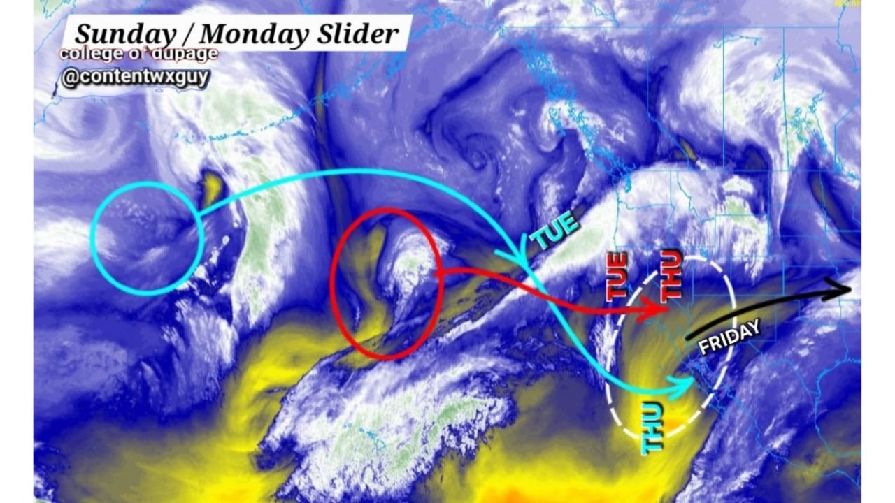
The imagery shows a strong Pacific disturbance entering the western United States late in the week, with energy diving southeast before attempting to round the base of a trough and slide eastward.
Key features highlighted in the data include:
- A primary upper-level wave crossing the western U.S.
- A secondary shortwave diving southeast and attempting to interact with downstream energy
- A developing baroclinic zone along the East Coast by late week
This type of pattern often leads to track-sensitive winter storms, where small changes in timing and amplification determine who sees the most significant impacts.
Track Determines Who Gets the Snow
According to the guidance shown:
- If the system tracks flatter, the bulk of precipitation would remain focused across the Mid-Atlantic, with weaker forcing and lighter snowfall farther north.
- If the system amplifies, the storm could gain latitude, allowing Southern New England to experience stronger lift and heavier snowfall, similar to the late-January event referenced in the data.
The graphic specifically highlights Tuesday into Thursday as the critical window when the storm’s evolution and track become clearer, with downstream impacts unfolding shortly afterward.
Timing Window: Late Week Into Next Weekend
Based on the timeline depicted:
- Upper-level energy begins organizing early to midweek
- East Coast impacts become possible late week
- The most meaningful winter weather threat appears to align with the Sunday–Monday period
At this range, confidence remains low to moderate, which is typical for slider-type systems that depend on precise phasing of atmospheric features.
Why Confidence Is Still Limited
Meteorologists caution that slider systems are among the most difficult winter storms to pin down at long range. Minor differences in:
- Trough depth
- Jet stream orientation
- Timing of interacting shortwaves
can drastically shift snowfall outcomes by hundreds of miles.
For now, the data supports continued monitoring rather than locked-in forecasts, especially for residents from the Mid-Atlantic through Southern New England.
2What to Watch Going Forward
As the event draws closer, forecasters will be watching:
- Whether the system amplifies or stays flat
- How quickly energy phases along the East Coast
- The strength of cold air available on the north side of the track
Updates later this week should bring better clarity on snowfall placement and intensity.
Stay with WaldronNews.com for continued winter weather coverage, forecast updates, and detailed breakdowns as this potential storm moves closer.