
Upper-Level Low Eyed for Texas Late Next Week as Storm Track Signals Rain and Scattered Thunderstorms Across the Southern U.S.
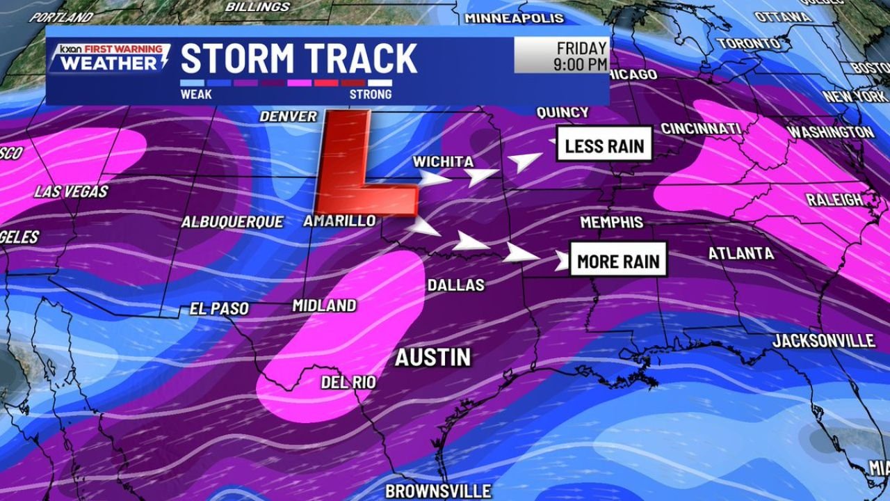
UNITED STATES — Forecasters are closely monitoring a potential upper-level low expected to track toward Texas late next week, a setup that could bring rain and scattered storms to parts of the Southern Plains and Lower Mississippi Valley, according to the storm-track graphic provided.
While the system remains too far out for precise impacts, the overall pattern is considered worth watching as energy organizes across the western and central United States and shifts eastward toward the end of the week.
Storm Track Centers on the Southern Plains
The map highlights a developing low-pressure feature positioned near Amarillo, with storm energy extending across New Mexico, West Texas, and into the Southern Plains.
Key locations shown within or near the primary storm corridor include:
- Amarillo and Wichita, near the core of the upper-level feature
- Dallas, Austin, and Del Rio, positioned in a corridor labeled for greater rainfall potential
- Albuquerque and El Paso, on the western side of the system
- Memphis and Atlanta, farther east where moisture continues downstream
Arrows on the graphic indicate the system’s eastward progression, suggesting expanding rain coverage as the feature advances.
Rain Distribution Not Expected to Be Uniform
The storm-track graphic explicitly differentiates rainfall potential across regions:
- Areas south and southeast of the low are marked for “more rain”, including North and Central Texas and portions of the Lower Mississippi Valley
- Locations farther north and northeast, including parts of the Midwest and Ohio Valley, are labeled for “less rain”
This contrast reflects how upper-level lows typically focus heavier precipitation on one side of the circulation, depending on track and moisture placement.
Timing Points to Late-Week Into Next Weekend Impacts
The map is timestamped Friday evening, aligning with messaging that the setup is most relevant for late next week into next weekend. At this stage, forecasters emphasize that:
- Confidence in specific rainfall totals or storm intensity remains low
- The overall pattern is the primary signal being monitored
- Short-term details will become clearer as the system approaches
What Residents Should Watch For
For communities across Texas and the southern U.S., this setup suggests the possibility of:
- Increasing rain chances late next week
- Periods of scattered thunderstorms, depending on how the upper-level low evolves
- Localized variations in rainfall amounts tied closely to the storm’s eventual track
As with many long-range setups, small shifts in the low’s position could significantly change where the heaviest rain ultimately falls.
WaldronNews.com will continue tracking this developing pattern and provide updates as confidence increases and details on timing and impacts become clearer.