
Arctic Air Traced Back to Near the North Pole Drives Near-Zero and Subzero Wind Chills Across Maryland and Pennsylvania
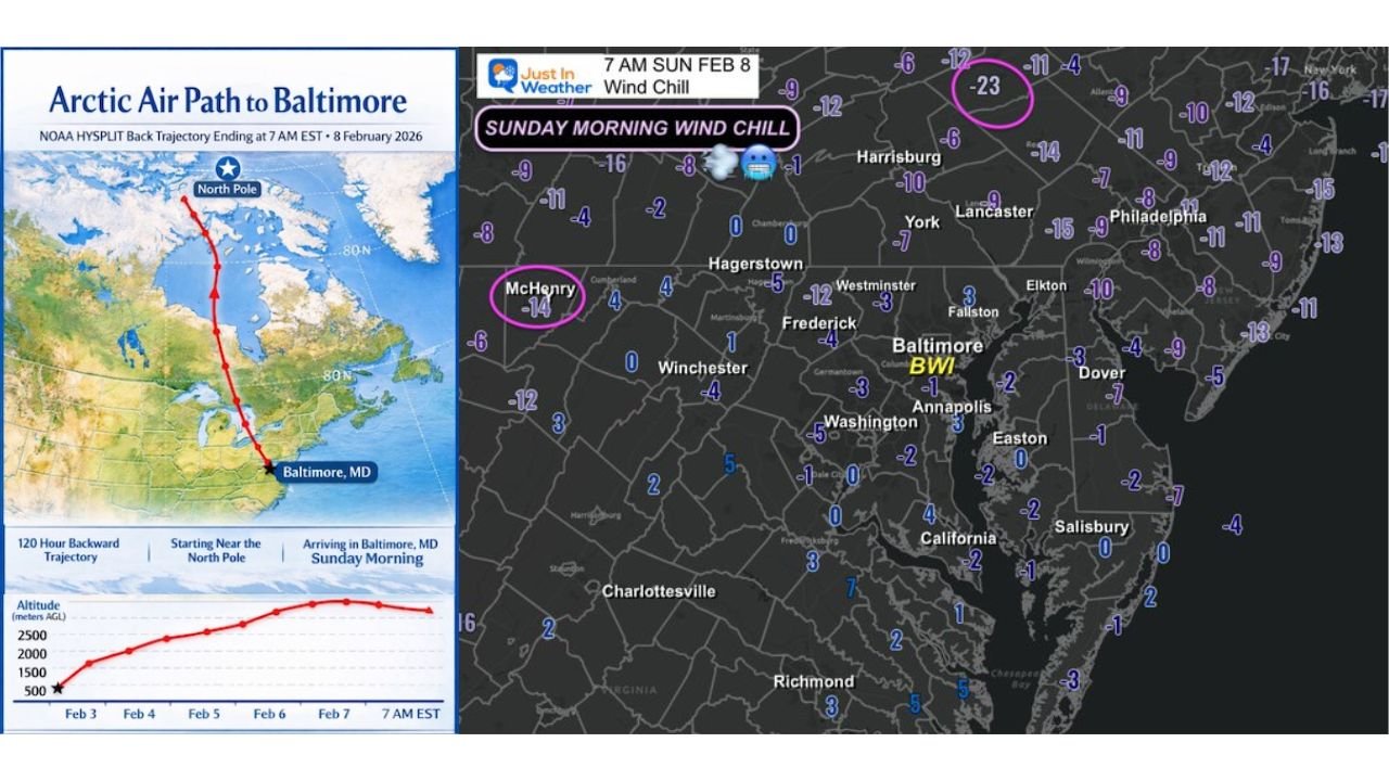
BALTIMORE, MARYLAND — An intense blast of Arctic air overspread the Mid-Atlantic and parts of Pennsylvania early Sunday morning, with data showing the air mass over Baltimore, Maryland, originated near the North Pole just five days ago, according to the NOAA HYSPLIT back-trajectory model.
At 7 a.m. Sunday, February 8, temperatures and wind chills across Maryland and Pennsylvania plunged to some of the coldest levels observed this winter, though forecasters note conditions were close to—but not necessarily—the absolute coldest of the season.
Arctic Air Traveled Directly South Into the Mid-Atlantic
Trajectory analysis indicates the air arriving in Baltimore followed a direct Arctic pathway, descending from near the North Pole and moving southward into the eastern United States over a five-day period.
This direct polar origin explains the sharp drop in wind chills despite actual air temperatures not being record-breaking in every location.
Temperatures and Wind Chills by Location
Observed conditions Sunday morning included:
- Baltimore/Washington International (BWI), Maryland:
- Temperature near 10°F
- Feels like -1°F
- McHenry, Maryland:
- Wind chill around -14°F
- Joe Zerbe Airport, Schuylkill County, Pennsylvania:
- Wind chill near -23°F
- Philadelphia and the Lehigh Valley, Pennsylvania:
- Wind chills in the single digits below zero
- Pocono Mountains Regional Airport, Pennsylvania:
- Wind chill as low as -33°F, the coldest value reported in the region
These readings place much of central and eastern Pennsylvania and western and central Maryland at or below zero for wind chill during the early morning hours.
Cold but Not the Coldest of the Winter
While the Arctic outbreak delivered dangerously cold wind chills, forecasters note that actual temperatures were close to—but not definitively—the coldest observed this winter in every location.
However, the wind component significantly amplified the impact, making conditions feel far colder than the thermometer alone would suggest.
Why Wind Chill Matters
Wind chills in the -10°F to -30°F range can cause frostbite on exposed skin in as little as 15 to 30 minutes, especially in elevated or open areas such as:
- The Poconos
- Higher elevations of western Maryland
- Open valleys and ridgelines across central Pennsylvania
The coldest values aligned closely with forecasts issued the day before, confirming the expected severity of the Arctic air mass.
What to Watch Going Forward
As the Arctic air settles and slowly modifies, forecasters will monitor:
- How quickly wind speeds decrease
- Overnight lows in sheltered inland valleys
- Any additional surges of polar air behind this system
Residents across Maryland and Pennsylvania are urged to continue taking cold-weather precautions during early morning and nighttime hours.
WaldronNews.com will continue tracking Arctic air intrusions and regional temperature trends as winter conditions evolve across the Mid-Atlantic.