
New England Snowstorm Review Shows Strong Forecast Accuracy Across Massachusetts, Connecticut, Rhode Island, New York, and Southern Maine Despite Banding Challenges
UNITED STATES — A complex winter storm that affected large portions of Massachusetts, Connecticut, Rhode Island, eastern New York, Long Island, and parts of southern Maine between February 6 and February 9, 2026, delivered widespread snowfall totals largely in line with forecasts issued days in advance, even as localized banding and mesoscale features created inevitable placement challenges.
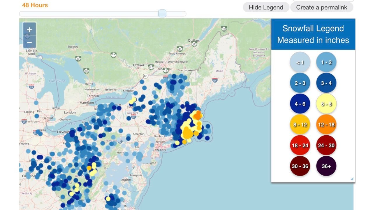
According to post-event snowfall data and forecast verification, much of central and eastern Massachusetts, northern Connecticut, and Rhode Island recorded totals within expected ranges, with heavier bands extending through Worcester County, portions of Middlesex County, and into coastal New England.
Forecast Performance and Overall Grade
The forecast received a B+ grade, reflecting strong performance on overall storm evolution, precipitation type, and regional totals — while acknowledging expected limitations in pinpointing narrow snow bands.
Forecasters correctly anticipated:
- The storm’s progression and timing
- The general snowfall ranges days ahead of the event
- The enhanced banding risk across interior New England
At the same time, the review noted that exact placement of banding, similar in behavior to lake-effect processes, proved difficult due to:
- Stalling frontal boundaries
- Subtle timing differences
- Mesoscale guidance errors of 20–40 miles, even within 6–12 hours of onset
Snowfall Distribution and Notable Misses
Snowfall totals generally aligned well across:
- Central Massachusetts
- Northern Connecticut
- Rhode Island
- Interior eastern New York
However, some discrepancies were observed:
- Middlesex County, MA, especially eastern portions, saw higher totals than forecast
- Essex County, MA and parts of Worcester County were slightly underdone
- Western Long Island, NY received more snow than expected despite being near a lower-end boundary
- Southern Maine underperformed, with totals closer to 1–2 inches instead of the forecast 2–5 inches
Despite these misses, forecasters noted the storm never fully tapped into the upper snowfall ceiling, limiting more widespread overperformance.
Why This Storm Was Especially Difficult to Pinpoint
This event combined several challenging elements:
- A slow-moving frontal zone
- Orographic enhancement, particularly from the White Mountains into central Massachusetts
- A narrow Integrated Vapor Transport (IVT) corridor
- Coastal enhancement that varied subtly by timing
While mesoscale models were consistent for nearly 36–48 hours, they shifted meaningfully close to the event, underscoring the difficulty of resolving small-scale features even with advanced guidance.
Accountability and Forecast Transparency
The post-storm review emphasized accountability as a critical part of forecasting, especially for complex winter systems.
Even with strong performance relative to other forecasts issued closer to onset, the decision was made to downgrade the final grade to reflect areas where execution fell short of precision standards.
The takeaway:
Accurate forecasting isn’t just about being close — it’s about owning the misses and learning from them.
Looking Ahead
While attention now turns to potential weather threats next week, the focus for now is on resetting after a demanding forecast cycle. Forecasters continue to monitor evolving patterns but stress that confidence remains low until clearer signals emerge.
For now, the event stands as a reminder of both:
- The strength of long-range pattern recognition
- The limits of precision in band-driven winter storms
Stay with WaldronNews.com for continued New England winter weather coverage, forecast analysis, and post-storm reviews.